File:Jan Mayen-Map-fr.svg
Jump to navigation
Jump to search

Size of this PNG preview of this SVG file: 332 × 357 pixels. Other resolutions: 223 × 240 pixels | 446 × 480 pixels | 714 × 768 pixels | 952 × 1,024 pixels | 1,905 × 2,048 pixels.
Original file (SVG file, nominally 332 × 357 pixels, file size: 9 KB)
Captions
Captions
Add a one-line explanation of what this file represents
| Description |
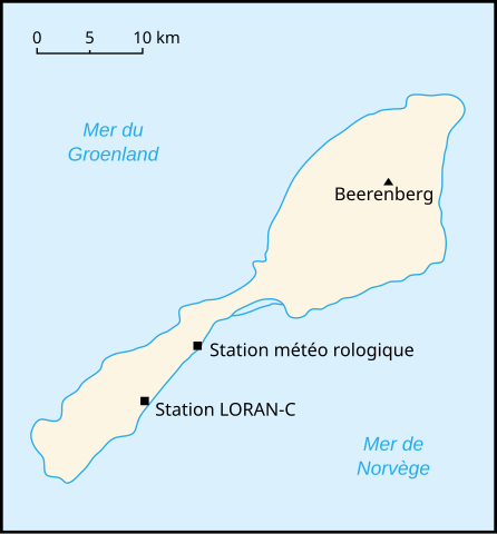
Français : Carte de l'île de Jan Mayen en français, Norvège English: Jan Mayen Island map in french, Norway |
||||||||
| Date | |||||||||
| Source | Own work | ||||||||
| Author | User:Kimdime69 | ||||||||
| Permission (Reusing this file) |
I, the copyright holder of this work, hereby publish it under the following licenses:
You may select the license of your choice. This file is licensed under the Creative Commons Attribution-Share Alike 1.0 Generic license.
|


|
This SVG file contains embedded text that can be translated into your language, using any capable SVG editor, text editor or the SVG Translate tool. For more information see: About translating SVG files. |
File history
Click on a date/time to view the file as it appeared at that time.
| Date/Time | Thumbnail | Dimensions | User | Comment | |
|---|---|---|---|---|---|
| current | 15:43, 30 December 2012 | | 332 × 357 (9 KB) | Tiger66 (talk | contribs) | Correction de bugs, amélioration du fichier, suppression de metadata Adobe, réduction du poids. |
| 15:35, 30 December 2012 |  | 332 × 357 (596 KB) | Tiger66 (talk | contribs) | Reverted to version as of 17:59, 24 April 2007 | |
| 15:32, 30 December 2012 |  | 332 × 357 (9 KB) | Tiger66 (talk | contribs) | Correction de bugs, amélioration du fichier, suppression de metadata Adobe, réduction du poids. | |
| 17:59, 24 April 2007 |  | 332 × 357 (596 KB) | Kimdime (talk | contribs) | {{Information |Description={{fr|Carte de l'île de Jan Mayen en français, Norvège}}{{en|Jan Mayen Island map in french, Norway}} |Source=œuvre personnelle / own work |Date=24/04/2007 |Author=User:Kimdime69 |Permission={{GFDL-self}}{{cc-by-sa}} |oth |
You cannot overwrite this file.
File usage on Commons
The following page uses this file: