File:MSH80 Hazard map April 1st.gif
Jump to navigation
Jump to search

Size of this preview: 592 × 600 pixels. Other resolutions: 237 × 240 pixels | 474 × 480 pixels | 894 × 906 pixels.
Original file (894 × 906 pixels, file size: 46 KB, MIME type: image/gif)
Captions
Captions
Add a one-line explanation of what this file represents
Summary[edit]
| Description |
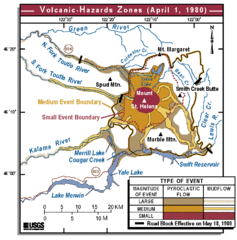
Deutsch: Karte, die die Verteilung der verschiedenen Gefahren eines möglichen Ausbruchs des Mount St. Helens für den 1. April 1980 zeigt.
English: Map showing distribution of hazards from a possible eruption of Mount St. Helens for April 1, 1980. |
| Date | |
| Source | USGS Cascades Volcano Observatory |
| Author | Lisa Faust |
Licensing[edit]
This image is in the public domain in the United States because it only contains materials that originally came from the United States Geological Survey, an agency of the United States Department of the Interior. For more information, see the official USGS copyright policy.
|
File history
Click on a date/time to view the file as it appeared at that time.
| Date/Time | Thumbnail | Dimensions | User | Comment | |
|---|---|---|---|---|---|
| current | 15:25, 31 March 2006 | | 894 × 906 (46 KB) | Mnh (talk | contribs) | ==English== {{Information| |Description=Map showing distribution of hazards from a possible eruption of Mount St. Helens for April 1, 1980. |Source=[http://vulcan.wr.usgs.gov/Volcanoes/MSH/May18/MSHThisWeek/32944/32944.htm USGS Cascades Volcano Observato |
You cannot overwrite this file.
File usage on Commons
There are no pages that use this file.
File usage on other wikis
The following other wikis use this file:
- Usage on de.wikipedia.org
- Usage on fr.wikipedia.org
- Usage on sv.wikipedia.org