File:Map of Naqsh-e Rostam.jpg
Jump to navigation
Jump to search
No higher resolution available.
Map_of_Naqsh-e_Rostam.jpg (717 × 579 pixels, file size: 179 KB, MIME type: image/jpeg)
Captions
Captions
Add a one-line explanation of what this file represents
Summary[edit]
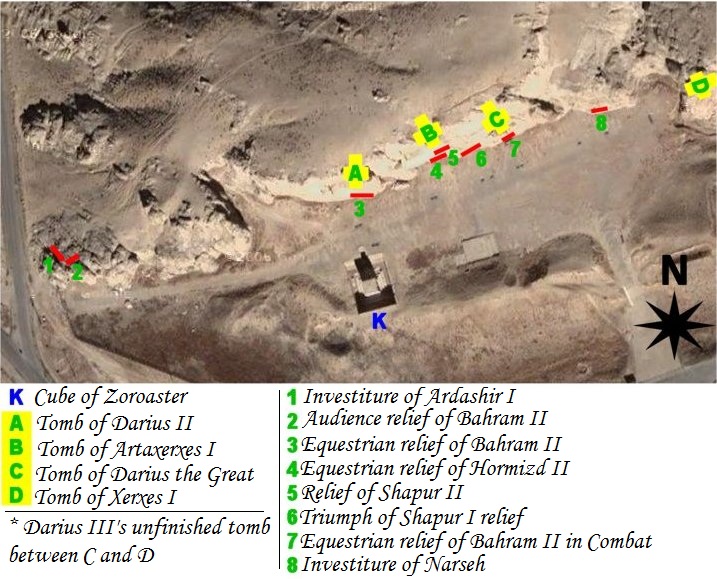
| Description | map of archeological site of Naqsh-e Rostam (Iran, fars Province, city of Marvdasht) |
| Date | |
| Source | Own work using NASA's satellite picture of the place and an artifact sheme according to belgium archeologist Louis Vanden Berghe. |
| Author | Pentocelo |
| Other versions | with french legends Image:Map of Naqsh-e Rostam (fr).jpg |
.jpg)
Licensing[edit]
| I, the copyright holder of this work, release this work into the public domain. This applies worldwide. In some countries this may not be legally possible; if so: I grant anyone the right to use this work for any purpose, without any conditions, unless such conditions are required by law. |
File history
Click on a date/time to view the file as it appeared at that time.
| Date/Time | Thumbnail | Dimensions | User | Comment | |
|---|---|---|---|---|---|
| current | 04:56, 27 February 2011 | | 717 × 579 (179 KB) | Dr. Persi (talk | contribs) | I took this file from the original work done by the User Pentocelo. This is his original work and therefore the credit belongs to him. He however uploaded the file as no copyright, enabling me to improve his original version. He has created two versions o |
| 19:58, 6 February 2008 |  | 717 × 579 (75 KB) | Pentocelo~commonswiki (talk | contribs) | == Description == {{Information |Description= map of archeological site of Naqsh-e Rostam (Iran, fars Province, city of Marvdasht) |Source= Own work using NASA's satellite picture of the place and an artifact sheme according to belgium archeologist Louis | |
| 19:26, 6 February 2008 |  | 721 × 624 (83 KB) | Pentocelo~commonswiki (talk | contribs) | {{Information |Description= map of archeological site of Naqsh-e Rostam (Iran, fars Province, city of Marvdasht) |Source= Own work using NASA's satellite picture of the place and an artifact sheme according to belgium archeologist Louis Vanden Berghe. |Da |
You cannot overwrite this file.
File usage on Commons
The following 3 pages use this file:
.jpg)
File usage on other wikis
The following other wikis use this file:
- Usage on ca.wikipedia.org
- Usage on de.wikivoyage.org
- Usage on en.wikipedia.org
- Usage on es.wikipedia.org
- Usage on it.wikipedia.org
- Usage on sl.wikipedia.org
- Usage on vi.wikipedia.org