File:Mer de Glace sketchmap by John Tyndall, 1857, from 1896 edition.png
Fichier d’origine (1 544 × 938 pixels, taille du fichier : 448 kio, type MIME : image/png)
Légendes
Légendes
| Description |
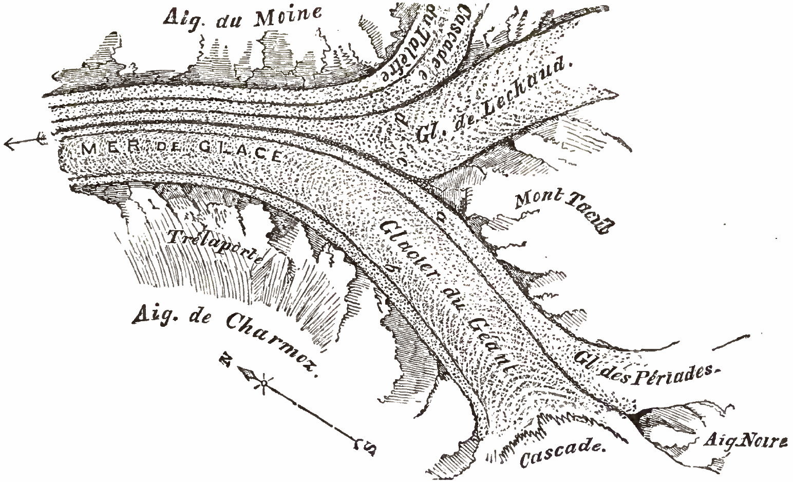
Mer de Glace sketchmap by John Tyndall, 1857 Fig. 7[1] shows Aiguille Noire to the south (bottom-right) dividing the Cascade at the west (bottom) from Glacier des Périades (right) which flows north to join Glacier du Géant flowing south to north (14 degrees clockwise) between Mont Tacul on the east (centre right) and Aiguilles de Charmoz to the west (bottom alongside morraine 'b'). This forms the medial morraine 'a'. Some 3 kilometres downstream, Glacier de Lechaud joins du Géant, forming medial morraine 'c'. Just prior to this confluence, Cascade du Talèfre, with its own medial morraine 'e', joins Lechaud forming morraine 'd'. Here the glacier is known as the Mer De Glace and flows north-north-west (leftwards) between Aiguille du Moine on the east and Trélaporte on the west. Notes
References
|
||||
| Date | |||||
| Source | PDF from https://archive.org/details/glaciersalpsbeing00tyndrich or alternative: https://books.google.it/books?id=8_cN1DQ3mZ4C&printsec=frontcover&hl=en#PPA53,M1 | ||||
| Auteur | John Tyndall (1820-1893) | ||||
| Autorisation (Réutilisation de ce fichier) |
|
||||
Historique du fichier
Cliquer sur une date et heure pour voir le fichier tel qu'il était à ce moment-là.
| Date et heure | Vignette | Dimensions | Utilisateur | Commentaire | |
|---|---|---|---|---|---|
| actuel | 24 septembre 2016 à 20:13 | | 1 544 × 938 (448 kio) | Cmdrjameson (d | contributions) | Compressed with pngout. Reduced by 275kB (38% decrease). |
| 29 février 2008 à 18:36 |  | 1 544 × 938 (724 kio) | Wikibob~commonswiki (d | contributions) | {{Information |Description=Mer de Glace sketchmap by John Tyndall, 1857 Fig. 7<ref>Tyndall page 53 "Fig 7."</ref> shows Aiguille Noire to the south (bottom-right) dividing the Cascade at the west (bottom) from Glacier des Périades (right) which flows no |
Vous ne pouvez pas remplacer ce fichier.
Utilisations locales du fichier
Aucune page n’utilise ce fichier.
Utilisations du fichier sur d’autres wikis
Les autres wikis suivants utilisent ce fichier :
- Utilisation sur en.wikipedia.org
- Utilisation sur es.wikipedia.org
- Utilisation sur fr.wikipedia.org
- Utilisation sur pt.wikipedia.org
- Maps of glaciers
- Historical images of Mer de Glace
- Glacier de Leschaux
- Glacier du Tacul
- Glacier de Trélaporte
- Glacier des Périades
- Glacier de Talèfre
- Illustrations from John Tyndall's books
- 1896 maps
- Maps of glaciers of Haute-Savoie
- Engraved maps
- Maps of confluences of glaciers
- Glaciological maps of Haute-Savoie
- Glaciological maps of the Alps
- Maps of glaciers of France
- Maps of glaciers of the Alps