File:Messinian palaeogeography.svg
Jump to navigation
Jump to search

Size of this PNG preview of this SVG file: 423 × 501 pixels. Other resolutions: 203 × 240 pixels | 405 × 480 pixels | 648 × 768 pixels | 864 × 1,024 pixels | 1,729 × 2,048 pixels.
Original file (SVG file, nominally 423 × 501 pixels, file size: 24 KB)
Captions
Captions
Add a one-line explanation of what this file represents
Summary
[edit]
| Description |
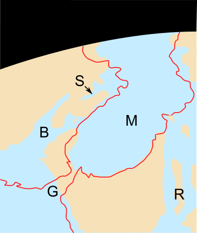
English: The palaeogeography of the Mediterranean region during the Messinian. After a "Google Earth" style mock-up, original paper unknown.
|
| Source | Own work |
| Author | Verisimilus |
Licensing
[edit]
I, the copyright holder of this work, hereby publish it under the following license:
This file is licensed under the Creative Commons Attribution 3.0 Unported license.
- You are free:
- to share – to copy, distribute and transmit the work
- to remix – to adapt the work
- Under the following conditions:
- attribution – You must give appropriate credit, provide a link to the license, and indicate if changes were made. You may do so in any reasonable manner, but not in any way that suggests the licensor endorses you or your use.
File history
Click on a date/time to view the file as it appeared at that time.
| Date/Time | Thumbnail | Dimensions | User | Comment | |
|---|---|---|---|---|---|
| current | 13:01, 24 June 2011 | | 423 × 501 (24 KB) | Ciaurlec (talk | contribs) | Changed colours, to uniform all the palaeogeographic maps |
| 21:11, 4 April 2008 |  | 423 × 501 (29 KB) | Smith609 (talk | contribs) | {{Information |Description=The palaeogeography of the Mediterranean region during the Messinian. After a "Google Earth" style mock-up, original paper unknown. |Source=self-made |Date= |Author= Verisimilus |Permission= |other_versions |
You cannot overwrite this file.
File usage on Commons
There are no pages that use this file.
File usage on other wikis
The following other wikis use this file:
- Usage on ca.wikipedia.org
- Usage on de.wikipedia.org
- Usage on en.wikipedia.org
- Usage on es.wikipedia.org
- Usage on hu.wikipedia.org
- Usage on it.wikipedia.org
- Usage on nl.wikipedia.org
- Usage on ru.wikipedia.org
- Usage on zh.wikipedia.org