File:NRC-regions-map.gif
Aller à la navigation
Aller à la recherche
Pas de plus haute résolution disponible.
NRC-regions-map.gif (550 × 415 pixels, taille du fichier : 43 kio, type MIME : image/gif)
Légendes
Légendes
Ajoutez en une ligne la description de ce que représente ce fichier
Description
[modifier]
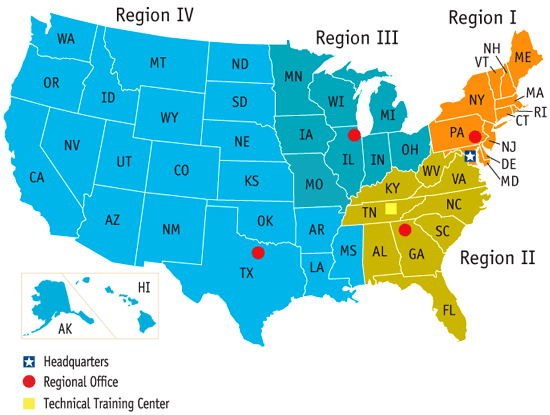
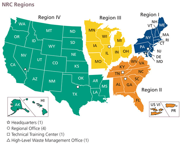
| Description | Map of the United States by Nuclear Regulatory Commission (NRC) Region (Now shows Mississippi in Region 4, rather than 2.) |
| Date | Last revised prior to July 21, 2008 (previous: February 17, 2007) |
| Source | http://www.nrc.gov/images/info-finder/region-state/regions-map.gif |
| Auteur | Nuclear Regulatory Commission |
| Autorisation (Réutilisation de ce fichier) |
"Information generated by the NRC or developed under an NRC contract is not copyrighted, unless indicated otherwise. Non-copyrighted material can be reproduced without permission; citation of the NRC as the source of the information is appreciated." |
Conditions d’utilisation
[modifier]
| This image is a work of a Nuclear Regulatory Commission employee, taken or made as part of that person's official duties. As a work of the U.S. federal government, the image is in the public domain in the United States. |
Historique du fichier
Cliquer sur une date et heure pour voir le fichier tel qu'il était à ce moment-là.
| Date et heure | Vignette | Dimensions | Utilisateur | Commentaire | |
|---|---|---|---|---|---|
| actuel | 21 juillet 2008 à 17:49 | | 550 × 415 (43 kio) | Wwoods (d | contributions) | |
| 12 janvier 2007 à 18:22 |  | 560 × 350 (23 kio) | BigrTex (d | contributions) | {{Information |Description=Map of the United States by Nuclear Regulatory Commission (NRC) Region |Source=http://www.nrc.gov/images/info-finder/region-state/regions-map.gif |Date=Last revised Tuesday, September 20, 2005 |Author=Nuclear Regulatory Commissi |
Vous ne pouvez pas remplacer ce fichier.
Utilisations locales du fichier
La page suivante utilise ce fichier :
Utilisations du fichier sur d’autres wikis
Les autres wikis suivants utilisent ce fichier :
- Utilisation sur de.wikipedia.org
- Utilisation sur en.wikipedia.org
- Utilisation sur en.wikibooks.org
- Utilisation sur fr.wikipedia.org
- Utilisation sur ja.wikipedia.org
- Utilisation sur ko.wikipedia.org
- Utilisation sur pl.wikipedia.org
- Utilisation sur zh.wikipedia.org