File:New York Harbor Nautical Chart.jpg

Fichier d’origine (906 × 595 pixels, taille du fichier : 172 kio, type MIME : image/jpeg)
Légendes
Légendes
Description[modifier]
| Description |
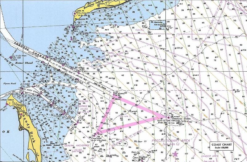
Nautical chart including LORAN TD lines for ocean approaches to New York Harbor. The chart shows TD lines, apparently for LORAN-A, which would make it the Nantucket-Chatam-Montuck-Sandy Hook-Fenwick-Bodie Is-Cape Hatteras chain. Note that the printed TD lines do not extend into inland waterway areas, as LORAN propagates poorly over land. The green 1000 lines curve heavily in this area. Note the "LORAN TR" mark at the tip of Sandy Hook near the focus of the curves. This would be Station "J" (3H5). The ochre 4000 lines (3H4) would correspond to the TD between the master and Station "H" at Cape Hatteras. The master station of this chain was at Sankaty Head on Nantucket, Massachussets. [1] The sharp angle between these sets of TD rings, especially to the east and north, would make it a poor pair for precise navigation. This is a detail of the original at:
|
| Date | 18 décembre 2004 (date de téléversement originale) |
| Source |
Perry-Castañeda Map Collection, University of Texas at Austin - Original URL (detail) - Copyright statement Originally uploaded on en.wikipedia; the description page was written by User:KeithTyler, and imported from here. |
| Auteur | Auteur inconnu |
| Autorisation (Réutilisation de ce fichier) |
PD-LAYOUT; PD-USGOV. |
![[2]](http://www.lib.utexas.edu/maps/national_atlas_1970/ca000219.jpg)
Conditions d’utilisation[modifier]
Ce média est dans le domaine public des États-Unis d’Amérique car son auteur est l’administration américaine comme précisé dans le code fédéral au Titre 17, Chapitre 1, Section 105. Pour en savoir plus : droit d’auteur.
Attention : Ceci ne concerne que le travail du Gouvernement Fédéral et pas celui des États, ou d’une autre subdivision géographique ou politique du pays.
|
 | |
| Ce fichier a été identifié comme étant exempt de restrictions connues liées au droit d’auteur, y compris tous les droits connexes et voisins. | ||
Historique du fichier
Cliquer sur une date et heure pour voir le fichier tel qu'il était à ce moment-là.
| Date et heure | Vignette | Dimensions | Utilisateur | Commentaire | |
|---|---|---|---|---|---|
| actuel | 14 juillet 2007 à 10:12 | | 906 × 595 (172 kio) | Massimiliano Lincetto (d | contributions) | {{Information |Description=Nautical chart including en:LORAN TD lines for ocean approaches to New York Harbor. The chart shows TD lines, apparently for LORAN-A, which would make it the NANTUCKET-CHATHAM-MONTUCK-SANDY HOOK-FENWICK-BODIE IS-CAPE HATTE |
Vous ne pouvez pas remplacer ce fichier.
Utilisations locales du fichier
Aucune page n’utilise ce fichier.
Utilisations du fichier sur d’autres wikis
Les autres wikis suivants utilisent ce fichier :
- Utilisation sur en.wikipedia.org
- Utilisation sur fr.wikipedia.org
- Utilisation sur it.wikipedia.org
- Utilisation sur lv.wikipedia.org
- Utilisation sur nl.wikipedia.org
- Utilisation sur ru.wikipedia.org
- Utilisation sur sl.wikipedia.org
- Utilisation sur vi.wikipedia.org