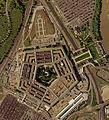
File:Pentagon satellite image.jpg
- Fichier
- Historique du fichier
- Utilisations locales du fichier
- Utilisations du fichier sur d’autres wikis
- Métadonnées

Fichier d’origine (2 261 × 2 146 pixels, taille du fichier : 4,02 Mio, type MIME : image/jpeg)
Légendes
Légendes
Description[modifier]
| DescriptionPentagon satellite image.jpg |
|
||
| Date | |||
| Source | U.S. Geological Survey | ||
| Auteur | Auteur inconnuUnknown author | ||
| Autres versions |
|
| Position de l'objet | 38° 52′ 16″ N, 77° 03′ 23″ O | Voir cet endroit et d’autres images sur : OpenStreetMap |
|---|
Conditions d’utilisation[modifier]
| Public domainPublic domainfalsefalse |
Cette image est placée dans le domaine public parce qu'elle contient des éléments issus de l'United States Geological Survey, une agence du Département de l'Intérieur des États-Unis. Pour plus d'information, consultez la politique officielle de copyright de l'USGS (en anglais)
Bahasa Indonesia ∙ català ∙ čeština ∙ Deutsch ∙ eesti ∙ English ∙ español ∙ français ∙ galego ∙ italiano ∙ Nederlands ∙ português ∙ polski ∙ sicilianu ∙ suomi ∙ Tiếng Việt ∙ Türkçe ∙ български ∙ македонски ∙ русский ∙ മലയാളം ∙ 한국어 ∙ 日本語 ∙ 中文 ∙ 中文(简体) ∙ 中文(繁體) ∙ العربية ∙ فارسی ∙ +/− |
Historique du fichier
Cliquer sur une date et heure pour voir le fichier tel qu'il était à ce moment-là.
| Date et heure | Vignette | Dimensions | Utilisateur | Commentaire | |
|---|---|---|---|---|---|
| actuel | 18 octobre 2022 à 17:08 |  | 2 261 × 2 146 (4,02 Mio) | Cryptic-waveform (d | contributions) | File:Pentagon-USGS-highres.jpg cropped 29 % horizontally, 39 % vertically using CropTool with precise mode. |
| 13 juin 2005 à 17:40 |  | 565 × 536 (108 kio) | Neutrality (d | contributions) | U.S. Geological Survey satellite image of the Pentagon, taken April 26, 2002. The reconstruction of the section damaged in the September 11 terrorist attacks is visible on the building's west (l |
Vous ne pouvez pas remplacer ce fichier.
Utilisations locales du fichier
Les 4 pages suivantes utilisent ce fichier :
Utilisations du fichier sur d’autres wikis
Les autres wikis suivants utilisent ce fichier :
- Utilisation sur ar.wikipedia.org
- Utilisation sur bh.wikipedia.org
- Utilisation sur bn.wikibooks.org
- Utilisation sur da.wikipedia.org
- Utilisation sur de.wikipedia.org
- Utilisation sur en.wikipedia.org
- Utilisation sur en.wikibooks.org
- Utilisation sur en.wikinews.org
- Utilisation sur en.wikiquote.org
- Utilisation sur eo.wikipedia.org
- Utilisation sur fi.wikinews.org
- Utilisation sur fr.wikipedia.org
- Utilisation sur fr.wiktionary.org
- Utilisation sur he.wikipedia.org
- Utilisation sur hy.wikibooks.org
- Utilisation sur id.wikibooks.org
- Utilisation sur it.wikipedia.org
- Utilisation sur it.wikiquote.org
- Utilisation sur min.wikipedia.org
- Utilisation sur ms.wikipedia.org
- Utilisation sur nn.wikipedia.org
- Utilisation sur ru.wikinews.org
- Utilisation sur scn.wikipedia.org
- Utilisation sur tl.wikiquote.org
- Utilisation sur uz.wikipedia.org
- Utilisation sur vi.wikipedia.org
- Utilisation sur vi.wikibooks.org
- Utilisation sur zh.wikipedia.org
- Utilisation sur zh.wikinews.org
Métadonnées
Ce fichier contient des informations supplémentaires, probablement ajoutées par l'appareil photo numérique ou le numériseur utilisé pour le créer.
Si le fichier a été modifié depuis son état original, certains détails peuvent ne pas refléter entièrement l'image modifiée.
| Commentaire de fichier JPEG | Created with GIMP |
|---|


