File:Plate tectonics map.gif
ನ್ಯಾವಿಗೇಷನ್ಗೆ ಹೋಗು
ಹುಡುಕಲು ಹೋಗು
ಈ ಮುನ್ನೋಟ ಗಾತ್ರ:೮೦೦ × ೫೪೧ ಪಿಕ್ಸೆಲ್ಗಳು. ಇತರ ರೆಸಲ್ಯೂಶನ್ಗಳು: ೩೨೦ × ೨೧೬ ಪಿಕ್ಸೆಲ್ಗಳು | ೬೪೦ × ೪೩೩ ಪಿಕ್ಸೆಲ್ಗಳು | ೧,೦೨೪ × ೬೯೨ ಪಿಕ್ಸೆಲ್ಗಳು | ೧,೨೮೦ × ೮೬೫ ಪಿಕ್ಸೆಲ್ಗಳು | ೨,೫೬೦ × ೧,೭೩೧ ಪಿಕ್ಸೆಲ್ಗಳು | ೩,೩೮೦ × ೨,೨೮೫ ಪಿಕ್ಸೆಲ್ಗಳು.
ಮೂಲ ಕಡತ (೩,೩೮೦ × ೨,೨೮೫ ಚಿತ್ರಬಿಂದು, ಫೈಲಿನ ಗಾತ್ರ: ೨.೬೩ MB, MIME ಪ್ರಕಾರ: image/gif)
Captions
Captions
Add a one-line explanation of what this file represents
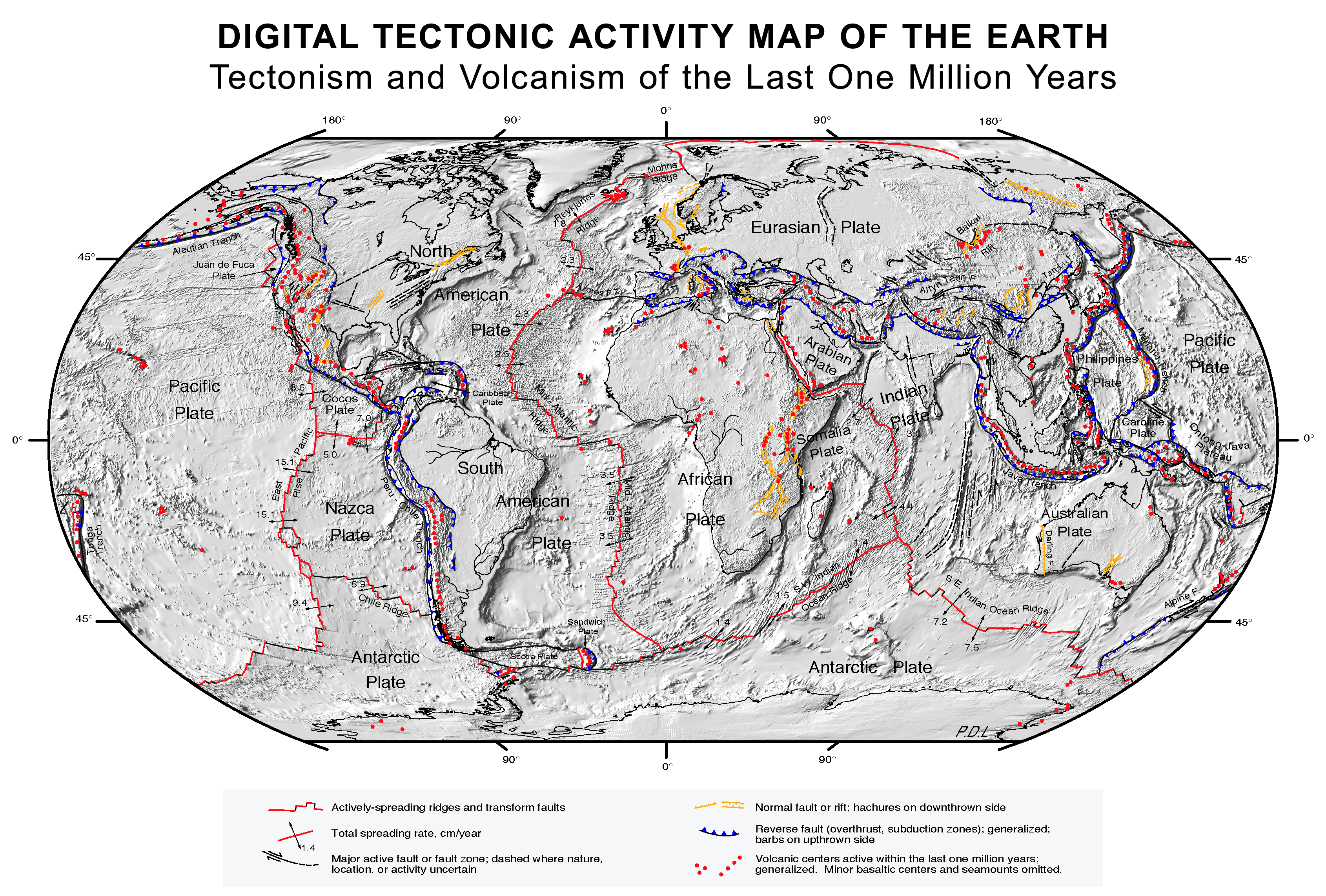
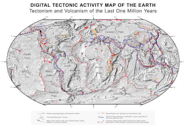
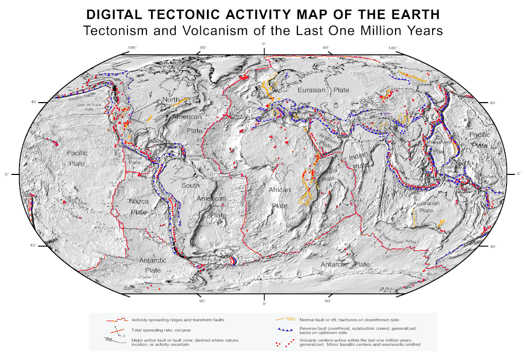
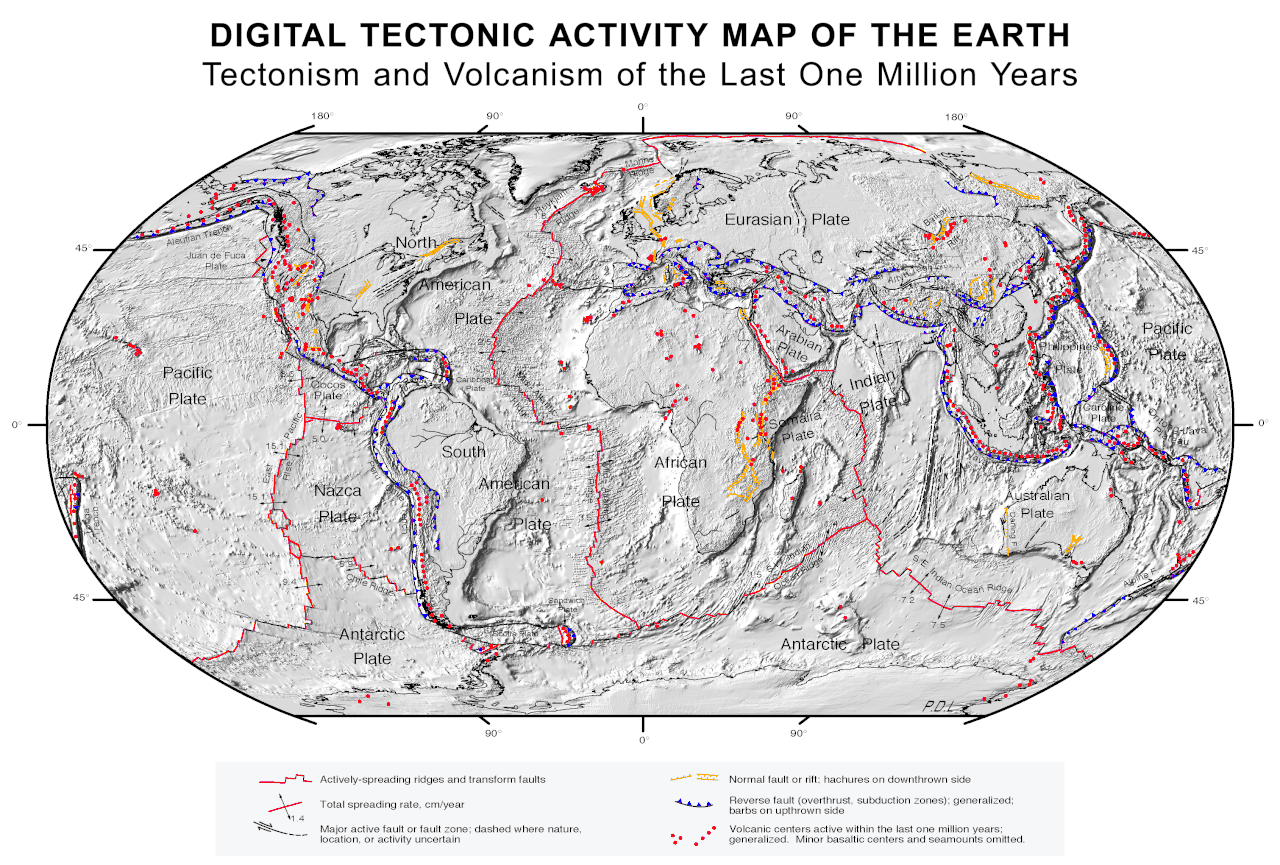
Tectonic activity map
ಸಾರಾಂಶ
[ಸಂಪಾದಿಸಿ]
| Description |
English: Quake epicenters Digital Tectonic Activity Map of the Earth (DTAM): |
| ದಿನಾಂಕ | October 2002 |
| ಆಕರ |
|
| ಸೃಷ್ಟಿಕರ್ತ |
NASA/Goddard Space Flight Center |
| Geotemporal data | |
| Spatial reference system | Robinson Projection |
| Georeferencing | If inappropriate please set warp_status = skip to hide. |
ಪರವಾನಗಿ
[ಸಂಪಾದಿಸಿ]
| This file is in the public domain in the United States because it was solely created by NASA. NASA copyright policy states that "NASA material is not protected by copyright unless noted". (See Template:PD-USGov, NASA copyright policy page or JPL Image Use Policy.) | ||
 |
Warnings:
|
ಕಡತದ ಇತಿಹಾಸ
ದಿನ/ಕಾಲ ಒತ್ತಿದರೆ ಆ ಸಮಯದಲ್ಲಿ ಈ ಕಡತದ ವಸ್ತುಸ್ಥಿತಿ ತೋರುತ್ತದೆ.
| ದಿನ/ಕಾಲ | ಕಿರುನೋಟ | ಆಯಾಮಗಳು | ಬಳಕೆದಾರ | ಟಿಪ್ಪಣಿ | |
|---|---|---|---|---|---|
| ಪ್ರಸಕ್ತ | ೦೯:೪೧, ೨೬ ಆಗಸ್ಟ್ ೨೦೧೭ | | ೩,೩೮೦ × ೨,೨೮೫ (೨.೬೩ MB) | Nagualdesign (ಚರ್ಚೆ | ಕಾಣಿಕೆಗಳು) | White background. |
| ೦೯:೨೦, ೨೬ ಆಗಸ್ಟ್ ೨೦೧೭ |  | ೩,೩೮೦ × ೨,೨೮೫ (೨.೬೩ MB) | Nagualdesign (ಚರ್ಚೆ | ಕಾಣಿಕೆಗಳು) | Minor correction. | |
| ೦೯:೧೬, ೨೬ ಆಗಸ್ಟ್ ೨೦೧೭ |  | ೩,೩೮೦ × ೨,೨೮೫ (೨.೬೩ MB) | Nagualdesign (ಚರ್ಚೆ | ಕಾಣಿಕೆಗಳು) | Rearranged elements, removed clutter. | |
| ೧೦:೫೨, ೧೬ ಏಪ್ರಿಲ್ ೨೦೧೧ |  | ೩,೫೭೭ × ೨,೩೧೩ (೨.೬೮ MB) | Michael Metzger (ಚರ್ಚೆ | ಕಾಣಿಕೆಗಳು) | uploaded a new version of this file with much higher resolution | |
| ೧೨:೦೮, ೮ ಅಕ್ಟೋಬರ್ ೨೦೦೭ |  | ೧,೨೮೦ × ೮೩೮ (೩೫೯ KB) | Geni (ಚರ್ಚೆ | ಕಾಣಿಕೆಗಳು) | rmed nasa logo | |
| ೦೩:೧೯, ೧೭ ಫೆಬ್ರವರಿ ೨೦೦೫ |  | ೧,೨೮೦ × ೮೩೮ (೩೬೦ KB) | Quadell (ಚರ್ಚೆ | ಕಾಣಿಕೆಗಳು) | Plate Tectonics map ([http://epod.usra.edu/archive/epodviewer.php3?oid=39392 source]){{PD-USGov-NASA}}Category:World mapsCategory:Plate tectonicsCategory:Continental drift |
ನೀವು ಈ ಕಡತವನ್ನು ಪುನರ್ಲೇಖಿಸಲು ಸಾದ್ಯವಿಲ್ಲ.
ಕಡತ ಬಳಕೆ
ಈ ಕೆಳಗಿನ ಪುಟವು ಈ ಚಿತ್ರಕ್ಕೆ ಸಂಪರ್ಕ ಹೊಂದಿದೆ:
ಜಾಗತಿಕ ಕಡತ ಉಪಯೋಗ
ಈ ಕಡತವನ್ನು ಕೆಳಗಿನ ಬೇರೆ ವಿಕಿಗಳೂ ಉಪಯೋಗಿಸುತ್ತಿವೆ:
- af.wikipedia.org ಮೇಲೆ ಬಳಕೆ
- an.wikipedia.org ಮೇಲೆ ಬಳಕೆ
- ar.wikipedia.org ಮೇಲೆ ಬಳಕೆ
- az.wikipedia.org ಮೇಲೆ ಬಳಕೆ
- bcl.wikipedia.org ಮೇಲೆ ಬಳಕೆ
- be.wikipedia.org ಮೇಲೆ ಬಳಕೆ
- bn.wikipedia.org ಮೇಲೆ ಬಳಕೆ
- ca.wikipedia.org ಮೇಲೆ ಬಳಕೆ
- cs.wikipedia.org ಮೇಲೆ ಬಳಕೆ
- cv.wikipedia.org ಮೇಲೆ ಬಳಕೆ
- da.wikipedia.org ಮೇಲೆ ಬಳಕೆ
- de.wikipedia.org ಮೇಲೆ ಬಳಕೆ
- el.wikipedia.org ಮೇಲೆ ಬಳಕೆ
- en.wikipedia.org ಮೇಲೆ ಬಳಕೆ
- Plate tectonics
- List of tectonic plate interactions
- Lists of volcanoes
- Tectonics
- List of tectonic plates
- Wikipedia:WikiProject Seamounts/Images
- User talk:Newyorkadam
- User talk:Muffin Wizard/Archive 5
- Timeline of the development of tectonophysics (after 1952)
- User talk:PWNGWN
- User talk:Sahara4u/Archive 4
- User talk:Ryan115
- User talk:A.Minkowiski
- User talk:Simon Adler/Archive 1
- User talk:Geirfuglasker
- User talk:EMachine03/Archive
- User talk:BluJay
- User talk:TheEditor867
- User talk:CrawfordLou
- User talk:CryOCed
ಈ ಫೈಲ್ನ ಹೆಚ್ಚು ಜಾಗತಿಕ ಬಳಕೆಯನ್ನು ವೀಕ್ಷಿಸಿ.