File:TTPI-locatormap.png
Aller à la navigation
Aller à la recherche
Pas de plus haute résolution disponible.
TTPI-locatormap.png (326 × 225 pixels, taille du fichier : 11 kio, type MIME : image/png)
Légendes
Légendes
Ajoutez en une ligne la description de ce que représente ce fichier
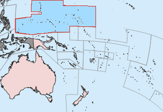
Trust Territory of the Pacific Islands among the Pacific Ocean

|
Cette image (de type historical map) devrait être recréée dans un format vectoriel, en tant que fichier SVG. Cela offrirait plusieurs avantages : voir Commons:Media for cleanup pour plus d'informations. Si une version SVG de cette image est déjà disponible, merci de bien vouloir l'envoyer. Après cela, remplacez ce modèle par {{vector version available|nouveau nom d'image.svg}}.
|
| Description |
Čeština: Mapa poručenského území Tichomořských ostrovů.
English: This is a locator map of the former Trust Territory of the Pacific Islands (TTPI). |
||||||||
| Source | The map is based off of a locator map of Palau found on the German Wiki at de:Bild:Palau-Pos.png; it was created by German Wiki user de:Benutzer:Tzzzpfffand licensed under the GFDL. The changes made from the original map are various. The current boundries of the CNMI, Palau, FSM, and RMI are merged and Guam has it's own boundary due to the fact it never was a part of the TTPI. Boundries have been compared with Image:MapofTTPI.gif for accuracy. As the orginial image was licensed under the GFDL, I place my modification of the orginial map under the GFDL as well. | ||||||||
| Auteur |
|
||||||||
| Autorisation (Réutilisation de ce fichier) |
|


Historique du fichier
Cliquer sur une date et heure pour voir le fichier tel qu'il était à ce moment-là.
| Date et heure | Vignette | Dimensions | Utilisateur | Commentaire | |
|---|---|---|---|---|---|
| actuel | 17 juin 2010 à 01:27 | | 326 × 225 (11 kio) | Ras67 (d | contributions) | cropped |
| 19 novembre 2006 à 14:52 |  | 330 × 228 (14 kio) | Electionworld (d | contributions) | == Summary == This is a locator map of the former Trust Territory of the Pacific Islands (TTPI). The map is based off of a locator map of Palau found on the German Wiki at de:Bild:Palau-Pos.png; it was created by German Wiki user [[:de:Benutzer:T |
Vous ne pouvez pas remplacer ce fichier.
Utilisations locales du fichier
Les 7 pages suivantes utilisent ce fichier :
Utilisations du fichier sur d’autres wikis
Les autres wikis suivants utilisent ce fichier :
- Utilisation sur ar.wikipedia.org
- Utilisation sur ast.wikipedia.org
- Utilisation sur azb.wikipedia.org
- Utilisation sur az.wikipedia.org
- Utilisation sur be.wikipedia.org
- Utilisation sur bg.wikipedia.org
- Utilisation sur ca.wikipedia.org
- Utilisation sur cs.wikipedia.org
- Utilisation sur da.wikipedia.org
- Utilisation sur de.wikipedia.org
- Utilisation sur en.wikipedia.org
- Trust Territory of the Pacific Islands
- Decolonization
- Japan–Oceania relations
- List of national border changes (1914–present)
- Aftermath of World War II
- High Commissioner of the Trust Territory of the Pacific Islands
- Wikipedia:Graphics Lab/Map workshop/Archive/Oct 2010
- Wikipedia:Reference desk/Archives/Humanities/2020 June 23
- Utilisation sur eo.wikipedia.org
- Utilisation sur es.wikipedia.org
- Utilisation sur fa.wikipedia.org
- Utilisation sur fi.wikipedia.org
- Utilisation sur fr.wikipedia.org
- Utilisation sur he.wikipedia.org
- Utilisation sur hu.wikipedia.org
- Utilisation sur hy.wikipedia.org
- Utilisation sur ia.wikipedia.org
- Utilisation sur id.wikipedia.org
- Utilisation sur it.wikipedia.org
- Utilisation sur ja.wikipedia.org
- Utilisation sur ko.wikipedia.org
- Utilisation sur lt.wikipedia.org
Voir davantage sur l’utilisation globale de ce fichier.