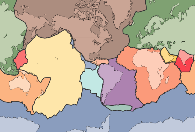
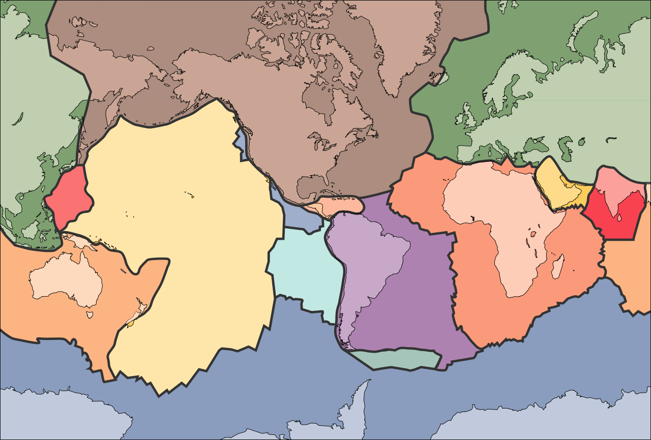
File:Tectonic plates (empty).svg
Aller à la navigation
Aller à la recherche

Taille de cet aperçu PNG pour ce fichier SVG : 681 × 461 pixels. Autres résolutions : 320 × 217 pixels | 640 × 433 pixels | 1 024 × 693 pixels | 1 280 × 866 pixels | 2 560 × 1 733 pixels.
Fichier d’origine (Fichier SVG, nominalement de 681 × 461 pixels, taille : 356 kio)
Légendes
Légendes
Ajoutez en une ligne la description de ce que représente ce fichier
الخلافه الرشيديهkp
Description[modifier]
| Description | |
| Date | 10 septembre 2005 (date de téléversement) |
| Source | File:Tectonic plates (empty).png |
| Auteur | Ævar Arnfjörð Bjarmason |
| Autres versions |
Ce fichier est dérivé de : Tectonic plates (empty).png:
[]
|
| SVG information | Le code de ce fichier SVG n'est pas valide en raison de 289 erreurs. Cette carte W3C-invalide a été créée avec Adobe Illustrator, et avec Inkscape. |


.png)


.svg&action=edit§ion=1)
.png)
Conditions d’utilisation[modifier]
.svg&action=edit§ion=2)
Cette image est placée dans le domaine public parce qu'elle contient des éléments issus de l'United States Geological Survey, une agence du Département de l'Intérieur des États-Unis. Pour plus d'information, consultez la politique officielle de copyright de l'USGS (en anglais)
|
Historique du fichier
Cliquer sur une date et heure pour voir le fichier tel qu'il était à ce moment-là.
| Date et heure | Vignette | Dimensions | Utilisateur | Commentaire | |
|---|---|---|---|---|---|
| actuel | 11 octobre 2006 à 02:04 | | 681 × 461 (356 kio) | Sting (d | contributions) | Borders correction integrated to the continents borders; size of picture |
| 10 octobre 2006 à 16:29 |  | 682 × 462 (285 kio) | Rogilbert~commonswiki (d | contributions) | correction de frontières 2 | |
| 10 octobre 2006 à 16:14 |  | 682 × 462 (212 kio) | Rogilbert~commonswiki (d | contributions) | correction des frontière | |
| 10 septembre 2005 à 13:48 |  | 682 × 462 (199 kio) | Ævar Arnfjörð Bjarmason (d | contributions) | SVG version of Image:Tectonic plates (empty).png {{PD-USGov-USGS}} Category:Plate tectonics |
Vous ne pouvez pas remplacer ce fichier.
Utilisations locales du fichier
Les 58 pages suivantes utilisent ce fichier :
- Tectonic plate
- File:682px-Plates tect2 sk.png
- File:Bankuai.png
- File:Laamade nimed.png
- File:Placas tect2 pt BR.svg
- File:Placas tectonicas-es.png
- File:Placas tectonicas2-es.svg
- File:Placas tectonicas es.svg
- File:Placas tectonicas mayores.svg
- File:Plaques català.jpg
- File:Plaques tectoniques.png
- File:Plaques tectoniques petit.gif
- File:Plates tect2-el.svg
- File:Plates tect2 af.svg
- File:Plates tect2 ar.png
- File:Plates tect2 bg.svg
- File:Plates tect2 bis en.svg
- File:Plates tect2 da.svg
- File:Plates tect2 en.svg
- File:Plates tect2 eu.png
- File:Plates tect2 fi.svg
- File:Plates tect2 fr.svg
- File:Plates tect2 gl.svg
- File:Plates tect2 heb.svg
- File:Plates tect2 hr.svg
- File:Plates tect2 id.svg
- File:Plates tect2 it.svg
- File:Plates tect2 ja.svg
- File:Plates tect2 ko.svg
- File:Plates tect2 lb.svg
- File:Plates tect2 mk.svg
- File:Plates tect2 nl.svg
- File:Plates tect2 oc.svg
- File:Plates tect2 su.svg
- File:Plates tect2 sv.svg
- File:Plates tect2 ta.svg
- File:Plates tect2 th.svg
- File:Plates tect2 uk.svg
- File:Plates tect2 zh.svg
- File:Plates tect cs.svg
- File:Platse tect2 nl.svg
- File:Plyty tektoniczne.svg
- File:Sicily Tectonic Plates.png
- File:Sicily Tectonic Plates copy.svg
- File:Sicily Tectonic plates.svg
- File:Tectonic Plates-oc.svg
- File:Tectonic plates-fr.png
- File:Tectonic plates (empty).png
- File:Tectonic plates (empty).svg
- File:Tectonic plates de.png
- File:Tectonic plates de.svg
- File:Tectonic plates movement pt BR.jpg
- File:Tectonic plates of Sicily (reupload).png
- File:Tectonica Placas pt BR.jpg
- File:Tectonica dei Placas.png
- File:Tektonikus lemez.svg
- File:Тектонске плоче.png
- Template:Other versions/Tectonic plates
.svg)
Utilisations du fichier sur d’autres wikis
Les autres wikis suivants utilisent ce fichier :
- Utilisation sur ar.wikipedia.org
- Utilisation sur az.wikipedia.org
- Utilisation sur bn.wikipedia.org
- Utilisation sur en.wikipedia.org
- Earth
- Internal structure of Earth
- Wikipedia:Graphics Lab/Image workshop/Archive/Jan 2009
- User:AvionArchon/sandbox
- User:Darth Tacker/TWA/Earth
- User:CheChe/Spoken Script
- User:Zanygenius/TWA/Earth
- User:Zanygenius/TWA/Earth/2
- User:Google7722/TWA/Earth
- Portal:Geophysics
- Portal:World
- User:FreshYoMama/TWA/Earth
- User:FreshYoMama/TWA/Earth/2
- User:Tblocks/TWA/Earth/2
- Utilisation sur en.wikiversity.org
- Utilisation sur eo.wikipedia.org
- Kontinento
- Platotektoniko
- Litosfero
- Tektona plato
- Ŝablono:Tektonaj platoj
- Antarkta plato
- Eŭrazia plato
- Nordamerika plato
- Sudamerika plato
- Afrika plato
- Pacifika plato
- Hindia plato
- Aŭstralia plato
- Plato Nazca
- Anatolia plato
- Arabia plato
- Filipina plato
- Kokosa plato
- Karibia plato
- Plato Juan de Fuca
- Hind-Aŭstralia Plato
- Utilisation sur es.wikipedia.org
- Utilisation sur fa.wikipedia.org
- Utilisation sur fr.wikipedia.org
- Utilisation sur gl.wikipedia.org
- Utilisation sur hu.wikipedia.org
- Utilisation sur id.wikipedia.org
Voir davantage sur l’utilisation globale de ce fichier.
.svg)
.svg&oldid=714091270)