File:Yazoo River control structure.jpg
Aller à la navigation
Aller à la recherche

Taille de cet aperçu : 800 × 533 pixels. Autres résolutions : 320 × 213 pixels | 640 × 427 pixels | 1 024 × 683 pixels | 1 500 × 1 000 pixels.
Fichier d’origine (1 500 × 1 000 pixels, taille du fichier : 345 kio, type MIME : image/jpeg)
Légendes
Légendes
Ajoutez en une ligne la description de ce que représente ce fichier
| Description |
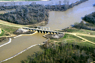
English: One of many control structures used to control flooding and the flow of water in the low-lying Yazoo River Basin in Mississippi, USA. |
|||
| Lieu | Yazoo River Basin, Mississippi, USA | |||
| Date | not specified or unknown | |||
| Source |
U.S. Army Corps of Engineers Digital Visual Library Image page Image description page Digital Visual Library home page |
|||
| Auteur | Alfred Dulaney, U.S. Army Corps of Engineers | |||
| Autorisation (Réutilisation de ce fichier) |
|
Historique du fichier
Cliquer sur une date et heure pour voir le fichier tel qu'il était à ce moment-là.
| Date et heure | Vignette | Dimensions | Utilisateur | Commentaire | |
|---|---|---|---|---|---|
| actuel | 7 avril 2007 à 16:48 | | 1 500 × 1 000 (345 kio) | DanMS (d | contributions) | {{Information | Description = {{en|One of many control structures used to control flooding and the flow of water in the low-lying Yazoo River Basin in Mississippi, USA.}} | Source = U.S. Army Corps of Engineers Digital Visual Library<br />[http |
Vous ne pouvez pas remplacer ce fichier.
Utilisations locales du fichier
Aucune page n’utilise ce fichier.
Utilisations du fichier sur d’autres wikis
Les autres wikis suivants utilisent ce fichier :
- Utilisation sur ar.wikipedia.org
- Utilisation sur bg.wikipedia.org
- Utilisation sur da.wikipedia.org
- Utilisation sur en.wikipedia.org
- Utilisation sur es.wikipedia.org
- Utilisation sur fr.wikipedia.org
- Utilisation sur fy.wikipedia.org
- Utilisation sur ko.wikipedia.org