Luisenstädtischer Kanal
Jump to navigation
Jump to search
English: Luisenstädtischer Kanal is a canal in Berlin-Kreuzberg and Berlin-Mitte, built in 1852 and reworked in 1926 into a park. The canal connected Landwehrkanal, beginning at Urbanhafen, and river Spree.
Deutsch: Der ehemalige Luisenstädtische Kanal verband den Landwehrkanal vom Berlin-Kreuzberger Urbanhafen aus mit der Spree in Berlin-Mitte. Gebaut 1852, ab 1926 zugeschüttet und als Park angelegt.
Maps
[edit]-
 Verlauf des Kanals. Die St.-Michaels-Kirche im Pharus-Plan Berlin von 1902 ist mit dem Pfeil markiert. Der rote Streifen zeigt den späteren Mauerverlauf, der grüne Punkt die Lage der West-Berliner (Ersatz)-Sankt-Michaelskirche
 -
 Berlin city wall (1855) with the canal in the south-east, beginning outside the old-Berlin-city at Urbanhafen, Landwehrkanal, near Wasserthor,
 -
 Verlauf des ehemaligen Luisenstädtischen Kanals im heutigen Straßenbild


Urbanhafen
[edit]-
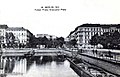
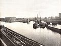 Urbanhafen around 1900
 -
 Urbanhafen, bank between Segitzdamm and Erkelenzdamm. This place was up to 1926 the mouth of Luisenstädtischer Kanal, which was reworked afterwards into a park.
 -
 dto.
dto. -
 The same place, swans on frozen water
 -
 View to the south bank with restaurant-boats and street „Planufer“
 -
 Urbanhafen at Fraenkelufer, view from Admiralbrücke
 -
 Restaurant-boat, opposite Fraenkelufer


Wassertorplatz
[edit]-
 Wassertor 1865
 -
 Alte Wassertorbrücke 1896
 -
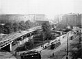 Construction of the elevated railway at Wassertorplatz, around 1901
 -
 Construction of the elevated railway on Skalitzer Str., at the corner to Luisenufer (today Segitzdamm and Erkelenzdamm) / Thorbecken, around 1900
 -
 U-Bahnlinie U1 teilt den Platz
 -
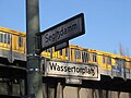 Straßenschilder mit U-Bahn
 -
 Elevated Railway
 -
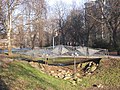 Am Wassertorplatz, Parkbrücke an Stelle der historischen Kanalbrücke von de:Hinrich Baller
 -
 Wassertorplatz, Südseite
 -
 Wassertorplatz am Erkelenzdamm mit Gründerzeithäusern
 -
 Jugendverkehrsschule vor Erkelenzdamm
 -
 Wassertorplatz, Nordseite an der Jugendverkehrsschule


Oranienplatz
[edit]-
 Oranienplatz um 1900
 -
 Oranienplatz 17 and Oranienstraße 40-41, Architects Cremer & Wolffenstein, build 1913
 -
 Drachenbrunnen, by Wiegand Witting, 1989


Engelbecken und St. Michaels Kirche
[edit]- See also: St.-Michaels-Kirche
-
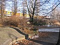
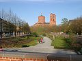
 Luisenstädtischer Kanal mit dem Engelbecken und der St.-Michaels-Kirche im Hintergrund, von der Waldemarstraße aus fotografiert
 -
 Engelbecken mit St.-Michaels-Kirche
 -
 Elisabethbrücke zwischen Engelbecken und späterem Immergrünen Garten um 1890
 -
 Engelbecken und Kanal um 1900
 -
 Engelbecken und Kaiser Franz Grenadierplatz um 1900
 -

-
 Indischer Brunnen
 -
 Luisenstädtischer Kanal und Rosengarten
 -
 Luisenstädtischer Kanal und Immergrüner Garten


_Indischer_Brunnen.jpg)
_Luisenst%C3%A4dtischer_Kanal.jpg)
_Luisenst%C3%A4dtischer_Kanal.jpg)
Bethaniendamm/Engeldamm - last part to Spree
[edit]Bethaniendamm was up to 1990 the border with the Berlin Wall
-
 Canal with hospital Bethanien at de:Mariannenplatz
 -
 Canal at Engeldamm/Bethaniendamm, seen from Engelbecken
 -
 Canal at Engeldamm/Bethaniendamm with St.-Thomas-Kirche in the background
 -
 St.-Thomas-Kirche at Bethaniendamm, built by en:Friedrich Adler
de:Friedrich Adler
between 1864 and 1869 -
 St.-Thomas-Kirche
 -
 Berlin Wall 1986
 -
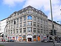
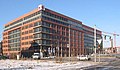 ver.di (trade union) central office Berlin-Brandenburg at Engeldamm. This place marks the end of the former Luisenstädtischer Kanal at its flowing to river Spree
 -
 ver.di (trade union)
 -
 Luisenstädtischer Kanal
 -
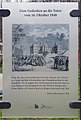 Gedenken an die Toten vom 16. Oktober 1848


_Luisenst%C3%A4dtischer_Kanal.jpg)
Some more impressions of the course
[edit]-
 View to Waldemarbrücke, Engelbecken and St.-Michaels-Kirche in the background. On the left the bust of trade-union-leader de:Carl Legien.
