Old maps of Rotterdam
Jump to navigation
Jump to search
Old maps of Rotterdam, see also en:History of Rotterdam and Maps of Rotterdam in Nationaal Archief
Origin of Rotterdam, until the 17th century[edit]
-
 Anno 1340
 -
 1550
1550 -
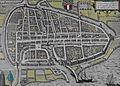
 plattegrond 1566
 -
 1573
1573 -
 1588
1588


17th century[edit]
- Maps of the surroundings
-
 1645
1645
- City maps
-
 1611
1611 -

-
 1649
1649 -
 1652
1652 -
 Haringvliet, 1690
 -
 1690
1690 -
 1694
1694


- Polders in 1611
-
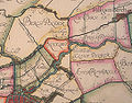 Bergpolder
 -
 Beukelsdijk
 -
 Blijdorpse polder
 -
 Delfshaven en Schoonderloo
 -
Hoflaan
-
 Kleiweg
 -
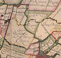
 Mathenesse
 -
 Oud-Mathenesse


18th century[edit]
- Maps of surroundings, city maps, plans... etc.
-
 1757
1757 -

-
 1769
1769 -
 1772
1772 -
 Rotterdam en omliggende landerijen, 18e eeuw


19th century[edit]
-
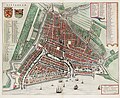
 1839
1839 -
 1839
1839 -
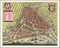
 1854
1854 -
 1864
1864 -
 1865
1865 -
 1865
1865 -
 1865
1865 -
 1872
1872 -
 1888
1888 -
 Katendrecht, 1889


Urban planning 19th century[edit]
-
Geprojecteerde waterwerken A. B. en C, ter verbetering van dit rivier-vak, 1772
-
 Ontwerp tot Indijking en Vergroting der Stad, Beyerinck & Conrad, 1834
 -
 Tweede Coolpolderproject W.N. Rose, 1858
 -
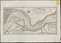
Riviervariant van W.N. Rose, 1864
-
 1873
1873 -
 Rotterdamse Handels-Vereeniging, 1874
 -
 1875
1875 -
 1882
1882


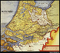
Rotterdam en omstreken in Gemeente Atlas van Nederland, 1865[edit]
-
Rotterdam No. 1
-
Rotterdam, no. 2
-
 Charlois
 -
 Delfshaven
 -
 Hilligersberg
 -
 IJsselmonde
 -
 Hoogvliet
 -
 Katendrecht
 -
 Kethel
 -
 Kralingen
 -
 Overschie
 -
 Pernis
 -
 Schiebroek


20th century[edit]
-
 1900 - general view
 -
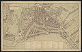
 1900 - detail Blijdorp
 -
 1905
1905 -

_door_Gemeentewerken.jpg)


Urban planning 20th century[edit]
-
 Uitbreidingsplan Linker Maasoever door A.C. Burgdorffer, 1917

See also[edit]
- Rotterdam