<nowiki>Rhäzüns; Rhäzüns; Rhäzüns; Rhäzüns; Rhäzüns; Rhäzüns; Rhäzüns; Rhäzüns; Ռեցյունս; 雷欽斯; Rhäzüns; Razén; Rhäzüns; Rhäzüns; Ruzunnes; Rhäzüns; Rhäzüns; Рецюнс; Rhäzüns; Rhäzüns; Rhäzüns; Rhäzüns; Rhäzüns; Rhäzüns; Rhäzüns; Rhäzüns; 雷钦斯; Rhäzüns; Rhäzüns; Rhäzüns; Рецюнс; Rhäzüns; Rhäzüns; Rhäzüns; Rhäzüns; Рецюнс; Rhäzüns; Rhäzüns; Rhäzüns; Rhäzüns; رهازونز; Rhäzüns; Рецюнс; comune svizzero; település Svájcban; Gemeinde im Kanton Graubünden in der Schweiz; komunë në Zvicër; մունիցիպալիտետ Շվեյցարիայի Գրիզոնս կանտոնում; 瑞士格劳宾登州市镇; İsviçre'de belediye; lungsod; kumun suis e kanton Graubünden; муніципалітет у Швейцарії; gemeente in Graubünden; kommun i kantonen Graubünden, Schweiz; بلدة سويسرية; gmejna w Šwicarskej; commune suisse; municipality in the canton of the Grisons in Switzerland; komunumo de Svislando; obec v kantonu Graubünden ve Švýcarsku; comuna suiza del cantón de los Grisones; Rhäzuns; Rhazuns; Rhazüns; Rhazuns; Razén; Рецюнс; Resyuns; Rhazuns; Rhäzüns GR; Rhazuns; Rhaezuens; Razén; Rhaezuens; Rhäzüns; Rhazuns; Rhaezuens</nowiki>
Rhäzüns
municipality in the canton of the Grisons in Switzerland


 Historisches Luftbild aus 500 m von 1928
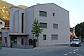 Gemeindehaus Rhäzüns
 Dorfeinfahrt
 Kirche Nossadunna (Maria Geburt)
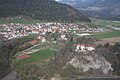 Rhäzüns mit Schloss
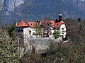 Schloss Rhäzüns, Südseite
 Mineralquelle
 Schulhaus
 Luftseilbahn Rhäzüns-Feldis
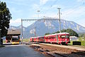 Bahnhof RhB
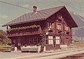 RhB Stationsgebaeude (1975)
 Wappen der Herren von Rhäzüns, Fresko aus Sogn Gieri


