Singapore
Vai alla navigazione
Vai alla ricerca
stato insulare del sud-est asiatico   ,_Marina_Bay,_Night_View_--_2019_--_4573-81.jpg)   _zoom.svg)   | |||||
| Carica un file multimediale | |||||
| Audio della pronuncia | |||||
|---|---|---|---|---|---|
| Istanza di | |||||
| Parte di | |||||
| Prende il nome da |
| ||||
| Cultura | |||||
| Luogo |
| ||||
| Situato sul mare / lago / fiume | |||||
| Capitale | |||||
| Forma di governo |
| ||||
| Organo legislativo | |||||
| Organo esecutivo | |||||
| Massima autorità giuridica | |||||
| Lingua ufficiale | |||||
| Inno | |||||
| Valuta | |||||
| Capo di Stato |
| ||||
| Capo del governo | |||||
| Presente nell'opera |
| ||||
| Data di fondazione o creazione |
| ||||
| Punto più alto | |||||
| Popolazione |
| ||||
| Superficie |
| ||||
| Religione | |||||
| Ha sostituito |
| ||||
| Dominio di primo livello | |||||
| Distinto da | |||||
| sito web ufficiale | |||||
 | |||||
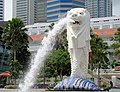
Singapore is a city state at the southern tip of peninsular Malaysia. It is an island approximately 40 by 20 km in size inhabited by more than five million people. Residents are mainly Chinese, Malay, Indian and Eurasian. Famous visitor attractions in Singapore include the Merlion statue, the Night Safari, Singapore Zoo, Sentosa Island, Pulau Ubin, Jurong Bird Park, and the Singapore Botanic Gardens.
This gallery contains quality images of Singapore.
simbolo nazionale[modifica]
-

-
 The coat of arms of Singapore in gold, mounted on the gate of the Istana which is the official residence of the President of Singapore
 -
-


skyline[modifica]
-
 night
night -
 view
view -

-

-

-

-

-

-

-

-
-

-

-
-

,_Gardens_By_The_Bay_--_2019_--_4759.jpg)
,_St_Andrew%27s_Cathedral_--_2019_--_4699.jpg)
,_View_from_Marina_Bay_Sands,_Gardens_by_the_Bay_--_2019_--_4722.jpg)
,_View_from_Marina_Bay_Sands,_Singapore_Flyer_--_2019_--_4720.jpg)
,_St_Andrew%27s_Cathedral_--_2019_--_4715.jpg)
,_View_from_Marina_Bay_Sands,_ArtScience_Museum_--_2019_--_4714.jpg)
,_The_Float_@_Marina_Bay_and_Bay_Grandstand_--_2019_--_4713.jpg)
,_The_Float_@_Marina_Bay_and_Bay_Grandstand_--_2019_--_4546.jpg)
,_The_Fullerton_Hotel_--_2019_--_4681.jpg)
,_The_Float_@_Marina_Bay_--_2019_--_4463.jpg)
,_The_Float_@_Marina_Bay_--_2019_--_4460.jpg)

-
 panoramic view
Scenes[modifica]
Aljunied[modifica]
Ang Mo Kio[modifica]
Bedok[modifica]
Bishan[modifica]
-
 Night view of Bishan
Boon Lay[modifica]
Bukit Batok[modifica]
-
 Bukit Batok East

Bukit Gombak[modifica]
-
 Bukit Gombak, Aerial View
 -
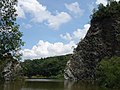 Little Guilin


Bukit Merah[modifica]
Bukit Timah[modifica]
Changi[modifica]
-
 Changi Beach
 -
 Expo MRT Station


Chinatown[modifica]
Chinese Garden[modifica]
-
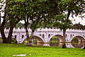 Chinese Garden Bridge

Clementi[modifica]
Downtown Core[modifica]
-
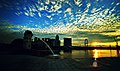 Sunrise at Marina Bay
 -
 An aerial view of the Downtown Core. In the centre are the Supreme Court of Singapore (with the disc-shaped structure on top) and the Old Supreme Court Building (with the dome)
 -

-

-

-

-

-
-
-
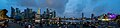
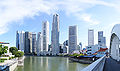
 The skyline of the Central Business District at dusk
 -

-

-

-
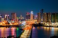
 The Fullerton Hotel Singapore and the Central Business District viewed from across the Singapore River
 -

-
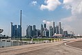
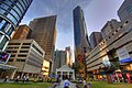
 Central Business District
 -
 View on Skyline from Esplanade
 -


.jpeg)

,_ArtScience_Museum_and_Marina_Bay_Sands_Hotel_--_2019_--_4686.jpg)
Eunos[modifica]
Geylang[modifica]
HarbourFront[modifica]
-
 Keppel Container Terminal

Hougang[modifica]
Jurong East[modifica]
Kembangan[modifica]
Khatib[modifica]
Little India[modifica]
Mandai[modifica]
-
 White tigers at the Singapore Zoo
 -


Orchard Road[modifica]
-
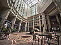 The courtyard of the Rendezvous Hotel Singapore on Bras Basah Road

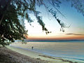
Pasir Ris[modifica]
-
 Pasir Ris Beach
 -
 Api Api River


Paya Lebar[modifica]
Pulau Ubin[modifica]
-
 Chek Jawa on Pulau Ubin,
 -
 offshore


Punggol[modifica]
Queenstown[modifica]
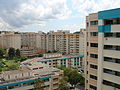
-
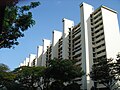
 High Rise HDB flats in Queenstown

Sentosa[modifica]
Singapore River[modifica]
-
 Aerial views of the Singapore River
 -

-
 The skyline of the Central Business District with Boat Quay and the Singapore River in the foreground
 -


Tampines[modifica]
Tanjong Pagar[modifica]
-
 Tanjong Pagar Container Terminal, viewed from The Sail@Marina Bay
 -
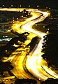 A night view of traffic in Tanjong Pagar
 -


Toa Payoh[modifica]
-
 HDB flats
 -

-
-
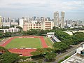 Toa Payoh Stadium


Woodlands[modifica]
-
 A newly constructed HDB flat
 -
 A view from Woodlands Avenue 9 after rain.
 -
 A rooftop view from HDB Block 738, with Lighthouse Evangelism and Woodlands Mart visible
 -
 A view from the 12th floor of HDB Block 876, Woodlands Avenue 9
 -
 HDB Block 880, Woodlands Street 82
 -
 HDB Block 878, Woodlands Avenue 9


,_Singapore.jpg)


Yew Tee[modifica]
Yishun[modifica]
.jpg)
mappa[modifica]
-
 luogo
luogo -
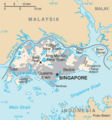 CIA map of Singapore
 -
 System Map of MRT and LRT
 -
 MET map
 -
 Outline map of Singapore

.png)

.svg)

Immagine satellitare[modifica]
-
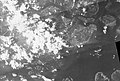 Photographed on 2 aprile 1963 (Singapore time) during the United States Department of Defense's Corona KH-4 reconnaissance satellite programme
 -
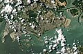
 A close-up of the photographs taken during the same mission showing RAF Changi (now Changi Air Base)
 -
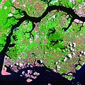
 A Landsat 7 image of Singapore taken on 28 aprile 2000
 -
-
_-_19630401.jpg)
_-_19630401.jpg)
_-_20000428.jpg)
_-_20030608.jpg)
.jpg)
