Türkenfeld
Jump to navigation
Jump to search
municipality of Germany    | |||||
| Upload media | |||||
| Pronunciation audio | |||||
|---|---|---|---|---|---|
| Instance of |
| ||||
| Part of |
| ||||
| Location | Fürstenfeldbruck, Upper Bavaria, Bavaria, Germany | ||||
| Head of government |
| ||||
| Population |
| ||||
| Area |
| ||||
| Elevation above sea level |
| ||||
| official website | |||||
 | |||||
Gemeinde und Kirchdorf in Oberbayern ![]() Germany
Germany
-
 Lage im Landkreis Fürstenfeldbruck
 -
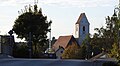
 Ortsansicht
 -
 Fuggerschloss, heute Sitz der GemeindeverwaltungMain category: Schloss Türkenfeld
 -
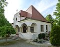
 Pfarrkirche Mariä Himmelfahrt
 -
 Leichenhalle
 -
 Mariensäule
 -
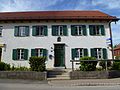 Wohnteil eines ehemaligen Einfirsthofes
 -
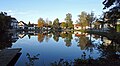 Dorfweiher
 -
 Neobarock-Villa im Zankenhausen (Echinger Strasse 22)


