User:Cqui/Corse
Les quelques photo prises a l'occasion de 13 jours en Corse, principalement des monuments historiques dont les photo manquaient sur Commons.
Église de Zigliara[edit]
-

-
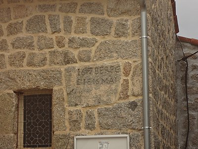 Pierre indiquant la date de construction, le 16 Mai 1678


| Object location | | View all coordinates using: OpenStreetMap |
|---|
Couvent Saint-François d'Istria[edit]
-

-
 Couvent à Petreto-Bicchisano


| Object location | | View all coordinates using: OpenStreetMap |
|---|
Échauguette de Sartène[edit]
Reste de fortification de la ville, Avenue Gabriel-Péri à Sartène


| Object location | | View all coordinates using: OpenStreetMap |
|---|
Fortin de Tizzano[edit]
Le Fortin, propriété privée, est entouré de hauts grillages.


| Object location | | View all coordinates using: OpenStreetMap |
|---|
Église San Giovanni de Grossa[edit]
Photos prises principalement depuis la route, je n'ai pas trouvé le chemin pour y aller de plus prés.
J'aurais peut-etre du sauter le mur avec le champs d'à coté qui lui etait accessible depuis le chemin menant au menhir de Vaccil Vecchiu.


| Object location | | View all coordinates using: OpenStreetMap |
|---|
Église Saint-Jean de Sainte-Lucie-de-Tallano[edit]
Un complexe de tuyaux liés à l'aménagement hydroélectrique du Rizzaneze a transformé l'accès à l'église, ne pas hésiter à laisser la voiture au bord de la route et continuer a pied, avec un bon GPS.


| Object location | | View all coordinates using: OpenStreetMap |
|---|
Maison Giacomoni[edit]
Maison à Sainte-Lucie-de-Tallano


| Object location | | View all coordinates using: OpenStreetMap |
|---|
Chapelle Sainte-Marie de Quenza[edit]


| Object location | | View all coordinates using: OpenStreetMap |
|---|
Église Saint-Georges de Quenza[edit]


| Object location | | View all coordinates using: OpenStreetMap |
|---|
Église Saint-Nicolas d'Aullène[edit]
Fin de journée, au moins deux couleurs d'éclairage publique et un photographe qui commence tout juste a s'essayer aux réglage de la balance des blancs, cela donne des effets... interessant .


| Object location | | View all coordinates using: OpenStreetMap |
|---|
Caserne génoise de Bonifacio[edit]
Porte le nom de caserne Montlaur sur la facade, Le bâtiment est désaffecté et en mauvais état, je lai identifié a partir des coordonnées et de l'adresse.

| Object location | | View all coordinates using: OpenStreetMap |
|---|
Église Saint-Jacques de Bonifacio[edit]
L'église génoise édifiée entre le XIIe et le début du XIVe siècle est maintenant utilisée pour des séminaires, des conférences, des expositions et des spectacles sous le nom d'espace Saint Jacques[1].
Le jour des photos, elle etait utilisée dans le cadre du festival de tango Argentin.


| Object location | | View all coordinates using: OpenStreetMap |
|---|
Couvent Saint-Dominique de Bonifacio[edit]
Couvent accolé à l'église du même nom.


| Object location | | View all coordinates using: OpenStreetMap |
|---|
Chapelle San Agostino de Chera[edit]
Une petite chapelle perdue dans un bois, perchée sur une petite hauteur, atteignable au bout d'un chemin pas facile a trouver depuis le village malgré le petit panneau indicateur.
Le toit n'existe plus et seul un bénitier de pierre subsiste a l’intérieur.
La porte n'est plus là mais des marques bizarres sur le seuil semblent indiquer un système a deux panneaux amovibles.

-

-

-

-

-
 Détail du seuil
 -

-
 Le petit bénitier en pierre
 -
 Le bénitier vu de dessus
 -

-

-

-

-
 La pancarte à 10 minutes du village


| Object location | | View all coordinates using: OpenStreetMap |
|---|
Chapelle Sainte Barbe de Pruno[edit]
Chapelle discrete, a deux pas de la route, a coté, un petit cimetière bien entretenu.


| Object location | | View all coordinates using: OpenStreetMap |
|---|
E Calanche[edit]
Ou I Calanchi, je n'ai trouvé semble-t-il qu'une partie du site seulement, un abris dans un chaos granitique.
Le site est toujours en cours de fouilles, d'ou les plastiques je suppose.


Menhir de Vaccil Vecchiu[edit]
Un menhir solitaire, au millieu d'une plaine, au bout d'une piste de terre.
Il y a quelques habitations autour.


Eglise Saint Barthelemy de Bonifacio[edit]

| Camera location | | View all coordinates using: OpenStreetMap |
|---|
Eglise Sainte Marie Madeleine de Bonifacio[edit]


| Camera location | | View all coordinates using: OpenStreetMap |
|---|
Sollacaro[edit]
-
 Français : Sollacaro vu depuis le chemin de Tabio au sud ouest.English: Sollacaro from Tabio.
Camera location 
View all coordinates using: OpenStreetMap 
-
 Français : Vue depuis le nord est.English: View from north east.
Camera location View all coordinates using: OpenStreetMap


Porto-Pollo[edit]
Port de Porto-Polo, commune de Serra-di-Ferro.
-
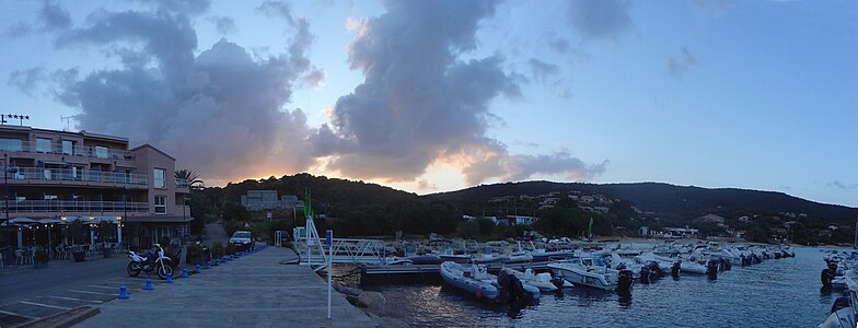 Vue d'une partie du port et des colines environnantes, juste après le couché du soleil.

| Camera location | | View all coordinates using: OpenStreetMap |
|---|
Pila-Canale[edit]


| Object location | | View all coordinates using: OpenStreetMap |
|---|
Pont de Calzola[edit]


| Object location | | View all coordinates using: OpenStreetMap |
|---|
Arbellara[edit]


| Object location | | View all coordinates using: OpenStreetMap |
|---|
