<nowiki>Uttenreuth; Уттенройт; Uttenreuth; Uttenreuth; Уттенройт; اوتنرویت; 乌滕罗伊特; Uttenreuth; Uttenreuth; ウッテンロイト; Uttenreuth; Уттенройт; Уттенройт; Uttenreuth; Uttenreuth; Uttenreuth; Uttenreuth; Uttenreuth; Uttenreuth; Uttenreuth; Утенројт; Uttenreuth; Uttenreuth; Uttenreuth; Uttenreuth; Uttenreuth; Uttenreuth; Uttenreuth; Uttenreuth; Уттенройт; Uttenreuth; Uttenreuth; Uttenreuth; Uttenreuth; أوتنرويت; Uttenreuth; Uttenreuth; chemun de la Germania; місто в Німеччині, федеральна земля Баварія; commune allemande; obec v zemském okresu Erlangen-Höchstadt v Německu; بلدة ألمانية في ولاية بافاريا; komunë në Gjermani; kommune i Bayern i Tyskland; gemeente in Beieren; település Németországban; Gemeinde in Deutschland; gmejna w Bayerskej; comune tedesco; municipality in district Erlangen-Höchstadt, Bavaria, Germany; komunumo en Bavario, Germanio; kumun alaman; Şaredariyeke Almanyayê; Uttenroyt; Уттенройт; Uttenreuth</nowiki>
Uttenreuth
municipality in district Erlangen-Höchstadt, Bavaria, Germany
This is a gallery page containing specially selected image and media files. They have been chosen as highlights of a particular topic, but do not represent the full range of files that are available on Commons. For a wider selection of files connected with Uttenreuth, see Category:Uttenreuth.


 Lage
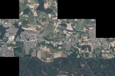
Lage Luftaufnahme (2020)
 evangelische Matthäuskirche (1765/1766)
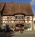 Gasthaus Schwarzer Adler (erbaut 1516)
 Indianerschlucht
.jpg)


