File:French and indian war map.svg
Jump to navigation
Jump to search

Size of this PNG preview of this SVG file: 745 × 533 pixels. Other resolutions: 320 × 229 pixels | 640 × 458 pixels | 1,024 × 733 pixels | 1,280 × 916 pixels | 2,560 × 1,832 pixels.
Original file (SVG file, nominally 745 × 533 pixels, file size: 1.38 MB)
Captions
Captions
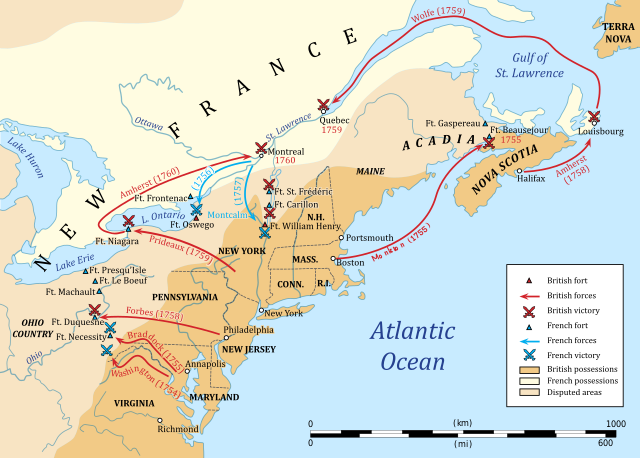
Map of the French and Indian War.
Summary[edit]
| Description |
English: Map of the French and Indian War. Français : Carte de la guerre de la Conquête (1754 - 1760) en Amérique du Nord. Guerre de Sept Ans en Europe (1755 - 1763). |
| Date | |
| Source | Own work |
| Author | Hoodinski |
Licensing[edit]
I, the copyright holder of this work, hereby publish it under the following license:
This file is licensed under the Creative Commons Attribution-Share Alike 3.0 Unported license.
- You are free:
- to share – to copy, distribute and transmit the work
- to remix – to adapt the work
- Under the following conditions:
- attribution – You must give appropriate credit, provide a link to the license, and indicate if changes were made. You may do so in any reasonable manner, but not in any way that suggests the licensor endorses you or your use.
- share alike – If you remix, transform, or build upon the material, you must distribute your contributions under the same or compatible license as the original.
File history
Click on a date/time to view the file as it appeared at that time.
| Date/Time | Thumbnail | Dimensions | User | Comment | |
|---|---|---|---|---|---|
| current | 20:45, 4 November 2018 | | 745 × 533 (1.38 MB) | Sémhur (talk | contribs) | Ft. Niagara was on the shore of Lake Ontario and Niagara River. |
| 20:28, 25 July 2018 |  | 745 × 533 (1.37 MB) | Sémhur (talk | contribs) | Update: scale | |
| 20:09, 23 July 2018 |  | 745 × 533 (1.37 MB) | Sémhur (talk | contribs) | Ft. Presqu'Isle | |
| 20:06, 23 July 2018 |  | 745 × 533 (1.37 MB) | Sémhur (talk | contribs) | Update: - Forbes victory against Fort Duquesne was in 1758, not 1757. - Attacks against Fort Beauséjour in 1755 was made by the sea, by Monkton. - Attacks against Louisbourg in 1758 was made from d’Halifax. | |
| 09:22, 29 January 2014 |  | 745 × 533 (2.47 MB) | Hoodinski (talk | contribs) | User created page with UploadWizard |
You cannot overwrite this file.
File usage on Commons
The following 6 pages use this file:
File usage on other wikis
The following other wikis use this file:
- Usage on ast.wikipedia.org
- Usage on azb.wikipedia.org
- Usage on az.wikipedia.org
- Usage on be-tarask.wikipedia.org
- Usage on bg.wikipedia.org
- Usage on cs.wikipedia.org
- Usage on de.wikipedia.org
- Usage on el.wikipedia.org
- Usage on en.wikipedia.org
- Usage on es.wikipedia.org
- Usage on fi.wikipedia.org
- Usage on fr.wikipedia.org
- Usage on ia.wikipedia.org
- Usage on id.wikipedia.org
- Usage on io.wikipedia.org
- Usage on ko.wikipedia.org
- Usage on lv.wikipedia.org
- Usage on mk.wikipedia.org
- Usage on ml.wikipedia.org
- Usage on mt.wikipedia.org
- Usage on no.wikipedia.org
- Usage on pl.wikipedia.org
- Usage on ro.wikipedia.org
- Usage on ru.wikipedia.org
- Usage on sr.wikipedia.org
- Usage on sv.wikipedia.org
- Usage on th.wikipedia.org
- Usage on tr.wikipedia.org
- Usage on uk.wikipedia.org
- Usage on www.wikidata.org