User talk:Sémhur

Bonjour
Sur cette carte on ne voit rien en planification, en rouge. Est-ce normal ?
--Io Herodotus (talk) 05:30, 2 January 2022 (UTC)
- Bonjour, il y a un nouveau plan avec les années, lien vers le plan peut-on l'adapter ? Merci. Hektor (talk) 13:58, 5 April 2022 (UTC)
- Voilà Hektor, j'ai ajouté les tronçons par années comme indiqué. Sémhur (talk) 19:29, 26 April 2022 (UTC)
- Merci beaucoup, c’est parfait. Ainsi on pourra suivre les mises en service. Hektor (talk) 20:16, 26 April 2022 (UTC)
- Voilà Hektor, j'ai ajouté les tronçons par années comme indiqué. Sémhur (talk) 19:29, 26 April 2022 (UTC)
File talk:Battle of Red Cliffs 208 extended map-en.svg : There is a typo on the bottom right. Yantze river should be Yangtze river. Hongsy (talk) 15:58, 11 January 2022 (UTC)
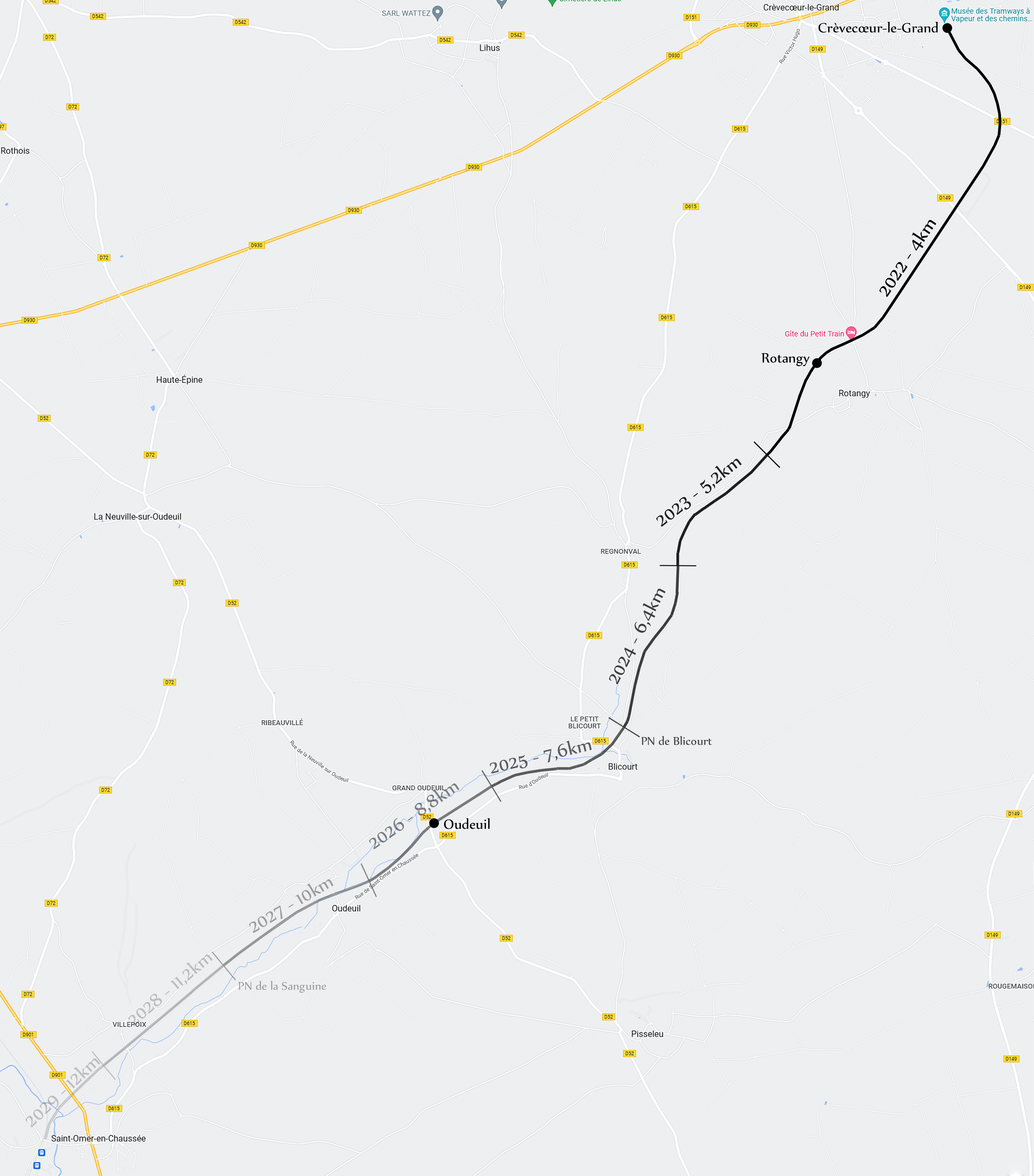
Train_à_vapeur_du_Beauvaisis.svg[edit]
Bonjour Sémhur, j'ai remarqué sur la carte actuelle que la ligne dite "en service" ne s'étend que jusqu'à la halte de Rotangy. Cela est vrai bien sûr, mais je trouve dommage qu'il n'y ait pas de distinction entre la section "à moitié achevée" par le MTVS entre cette halte et la limite de communauté de communes (quelques centaines de mètres après le premier pont en direction de Blicourt) et le reste de la ligne SNCF encore abandonnée. N'ayant aucune connaissance en construction de cartes, je m'en remets à vous pour, si c'est possible, ajouter une troisième légende "voie reconstruite" ou quelque chose du même type pour cette section d'environ 1km de voies, en attendant qu'elle soit utilisée. Merci d'avance, bonne soirée à vous. — Preceding unsigned comment added by Hugo Slr (talk • contribs) 21:39, 8 March 2022 (UTC)
- Bonjour Hugo Slr, j'ai fait la modification. Merci pour votre aide dans l'amélioration de cette carte. Sémhur (talk) 20:50, 9 March 2022 (UTC)
- (Re)-Bonjour Sémhur, merci pour votre aide sur cette page, j'ai reçu l'information aujourd'hui que le MTVS a signé un accord de subventions par la CCPV pour l’équivalent de 1.2km/an sur la section Rotangy-Oudeuil. Je pense donc que cette même section peut être marquée comme étant en "planification" en attendant qu'elle soit réellement reconstruite.
- Juste pour préciser bien sûr, cette section ne va que jusqu'à la halte d'Oudeuil sur la D52, rue de la Neuville sur Oudeuil je crois bien.
- Merci d'avance pour votre travail, et bonne journée. Hugo Slr (talk) 21:16, 3 April 2022 (UTC)
- Bonsoir Hugo Slr, eh non, c'était rue de la Gare
 ! Et c'est modifié. Sémhur (talk) 19:44, 4 April 2022 (UTC)
- Bonsoir Hugo Slr, eh non, c'était rue de la Gare
Hi Sémhur!
Your map is not Mercator projection (UTM) as mentioned in description. What projection is it? Can you give corner coordinates? That would be great. --Vollbracht (talk) 15:42, 26 March 2022 (UTC)
- Sorry! I messed up with normal and transversal Mercator projection. My fault. --Vollbracht (talk) 16:01, 26 March 2022 (UTC)
Carte des campus de Clermont[edit]
Bonjour,
J'espère que tu va bien. À tout hasard, aurais-tu un peu de temps pour créer une carte des campus de l'Université Clermont Auvergne à Clermont-Ferrand ? L'idée serait d'avoir quelque chose similaire à File:Rennes - Campus map-fr.svg mais en s'inspirant de la carte en tête de cette page (carte pas très lisible ni parlante je trouve). Si oui, cela me serait fort utile et je t'en serais reconnaissant. Et n'hésite pas si tu as la moindre question.
Cdlt, VIGNERON en résidence (talk) 07:50, 20 May 2022 (UTC)
- Bonjour VIGNERON en résidence, ok, je vais te faire ça (à mon rythme bien sûr ^^) Sémhur (talk) 20:07, 21 May 2022 (UTC)
- Merci et pas de problème, je suis en résidence à Clermont jusqu'à fin août, si tu avais le temps de faire cette carte avant ce serait parfait. Cdlt, VIGNERON en résidence (talk) 11:38, 23 May 2022 (UTC)
Path of 100 Towers: permission[edit]
GoodMorning, I'm Chiara, a student of an Italian university. I'm creating a wikipedia page about a path in Sardinia for a school project. I was searching for an image of Sardinia that I could edit, because I need to draw on it the streets of this trek. I just wanted to ask you the permission to use it and which is the source I have to put in the description. Thank you in advance. Chiara LIUCchiara1 (talk) 13:45, 5 December 2022 (UTC)
- Hello Chiara, of course you can use it, it's made for that!
- About permission, you can just add "Credit: Sémhur, CC-BY-SA"
- Sémhur (talk) 21:18, 5 December 2022 (UTC)
| File:Mobile Flag.png has been marked for speedy deletion. (Reason: CSD G2 (Unused and implausible, or broken redirect))
Why not upload a picture of a plant, animal, or anything else which fits into our scope. You can contribute any media type you want, including but not limited to images, videos, music, and 3D models. Start uploading now! If you don't have anything to upload at the moment, why not take a look at our best images or best videos, sounds and 3D models. If you have any doubts/questions don't hesitate to visit our help desk. |
User who nominated the file for deletion (Nominator) : Rkt2312.
I'm a computer program; please don't ask me questions but ask the user who nominated your file(s) for deletion or at our Help Desk. //Deletion Notification Bot 2 (talk) 22:46, 6 December 2022 (UTC)
Métro de Toulouse[edit]
Bonjour. La troisième ligne du métro de Toulouse, anciennement appelée Toulouse Aerospace Express, est devenue la ligne C du métro de Toulouse Source et a pris la couleur verte. Pourrais-tu mettre à jour le magnifique plan que tu avais fait à l'époque. Merci. Hektor (talk) 11:30, 17 December 2022 (UTC)
- Bonjour Hektor, c'est fait ! Il faudra la remettre à jour quand on connaitra le nouveau nom de l'ancienne ligne ferroviaire C. Pour l'instant j'ai juste indiqué « ex-C » ! Sémhur (talk) 16:30, 18 December 2022 (UTC)
- Merci beaucoup pour ta réponse rapide. « ex-C » me paraît effectivement le moins mauvais choix. Est-il possible de verdir et renommer le thermomètre également. Merci. Hektor (talk) 20:10, 18 December 2022 (UTC)
- Hektor, quand je regarde là, je vois que les noms des stations ont parfois changé... Dois-je me baser sur cette page pour mettre à jour le schéma et la carte ? Sémhur (talk) 21:16, 18 December 2022 (UTC)
- Oui, sans doute, et je ne doute pas que cela changera encore. Les noms des stations sont un enjeu pour les responsables comme on le voit à Paris pour le Grand Paris Express. Par contre il faudra réaligner les articles puisque par exemple certains ont jugé nécessaire de créer déjà des articles pour chaque station. Par contre je ne prendrais pas « Station Colomiers Gare » au pied de la lettre. Colomiers Gare me paraît plus vraisemblable. Hektor (talk) 21:30, 18 December 2022 (UTC)
- Bon, eh bien c'est déposé en l'état sur Commons. Jusqu'à la prochaine mise à jour. Sémhur (talk) 20:50, 19 December 2022 (UTC)
- Merci beaucoup. J’espere que la prochaine et dernière mise à jour correspondra aux noms définitifs des stations dans quelques années. Hektor (talk) 02:29, 20 December 2022 (UTC)
- Bonjour. On a une première volée de noms définitifs ici, mais hélas cinq noms demeurent provisoires. Je te laisse juge si tu veux faire la modification. Merci. Hektor (talk) 11:00, 8 February 2023 (UTC)
- Merci ! 22:27, 9 February 2023 (UTC)
- Bonjour. On a une première volée de noms définitifs ici, mais hélas cinq noms demeurent provisoires. Je te laisse juge si tu veux faire la modification. Merci. Hektor (talk) 11:00, 8 February 2023 (UTC)
- Merci beaucoup. J’espere que la prochaine et dernière mise à jour correspondra aux noms définitifs des stations dans quelques années. Hektor (talk) 02:29, 20 December 2022 (UTC)
- Bon, eh bien c'est déposé en l'état sur Commons. Jusqu'à la prochaine mise à jour. Sémhur (talk) 20:50, 19 December 2022 (UTC)
- Oui, sans doute, et je ne doute pas que cela changera encore. Les noms des stations sont un enjeu pour les responsables comme on le voit à Paris pour le Grand Paris Express. Par contre il faudra réaligner les articles puisque par exemple certains ont jugé nécessaire de créer déjà des articles pour chaque station. Par contre je ne prendrais pas « Station Colomiers Gare » au pied de la lettre. Colomiers Gare me paraît plus vraisemblable. Hektor (talk) 21:30, 18 December 2022 (UTC)
- Hektor, quand je regarde là, je vois que les noms des stations ont parfois changé... Dois-je me baser sur cette page pour mettre à jour le schéma et la carte ? Sémhur (talk) 21:16, 18 December 2022 (UTC)
- Merci beaucoup pour ta réponse rapide. « ex-C » me paraît effectivement le moins mauvais choix. Est-il possible de verdir et renommer le thermomètre également. Merci. Hektor (talk) 20:10, 18 December 2022 (UTC)
carte des anciennes provinces de France[edit]
Bonjour,
J'ai trouvé à l'article "Territoires du royaume de France" une très intéressante carte des anciennes provinces. Je ne connais pas bien Wikipedia, mais il semble que vous ayez participé à sa réalisation. Ma question : auriez-vous une autre version vectorielle de ce fichier, en particulier .shp, .json, .gpkg... qui me permettrait de travailler avec les logiciels SIG ? Merci d'avance pour votre réponse. Jldupouey (talk) 17:13, 6 February 2023 (UTC)
.svg)
- Bonjour Jldupouey. La carte en question (Provinces of France (numered-monochrome).svg je suppose) a été créée par Milenioscuro. Mon nom n'apparait que parce qu'il s'est servi d'une de mes cartes comme fond de carte.
- D'après ce que je lis, il s'est servi pour les tracés des limites des anciennes provinces de toute une série de cartes, ainsi que d'une autre au format .jpg. Je crains donc qu'il n'y ait pas de .shp, .json, .gpkg ou équivalent de disponible, désolé. Sémhur (talk) 20:45, 7 February 2023 (UTC)
- Merci pour votre réponse. Où voit-on qu'il s'est servi d'une série de cartes, dont une au format .jpg ? Je cherche partout sur la page de la carte en question (Provinces of France (numered-monochrome).svg, mais je ne vois pas où c'est indiqué. Merci d'avance pour votre aide, cela me permettra de mieux comprendre wikipédia. Jldupouey (talk) 11:20, 17 February 2024 (UTC)
- Bonjour Jldupouey. Eh bien sur la page de description de l'image, dans la partie « Source » il est écrit :
Own work
* File:France location map-Departements 1790.svg by Sémhur
* The maps located in this category: Category:SVG maps of historical provinces of France by department (d'où le « toute une série de cartes »)
* File:France anciennes provinces 1789.jpg
* File:Vidal-Lablache n°9 - Provinces en 1789.jpg
- Merci pour votre réponse. Où voit-on qu'il s'est servi d'une série de cartes, dont une au format .jpg ? Je cherche partout sur la page de la carte en question (Provinces of France (numered-monochrome).svg, mais je ne vois pas où c'est indiqué. Merci d'avance pour votre aide, cela me permettra de mieux comprendre wikipédia. Jldupouey (talk) 11:20, 17 February 2024 (UTC)
.svg)

|
File:Reconstitution d'un mégacéros 2.jpg has been listed at Commons:Deletion requests so that the community can discuss whether it should be kept or not. We would appreciate it if you could go to voice your opinion about this at its entry.
If you created this file, please note that the fact that it has been proposed for deletion does not necessarily mean that we do not value your kind contribution. It simply means that one person believes that there is some specific problem with it, such as a copyright issue. Please see Commons:But it's my own work! for a guide on how to address these issues. |
FunkMonk (talk) 12:05, 1 March 2023 (UTC)
Round 1 of Picture of the Year 2022 voting is open![edit]

Read this message in your language
Dear Wikimedian,
Wikimedia Commons is happy to announce that the 2022 Picture of the Year competition is now open. This year will be the seventeenth edition of the annual Wikimedia Commons photo competition, which recognizes exceptional contributions by users on Wikimedia Commons. Wikimedia users are invited to vote for their favorite images featured on Commons during the last year (2022) to produce a single Picture of the Year.
Hundreds of images that have been rated Featured Pictures by the international Wikimedia Commons community in the past year are all entered in this competition. These images include professional animal and plant shots, breathtaking panoramas and skylines, restorations of historical images, photographs portraying the world's best architecture, impressive human portraits, and so much more.
For your convenience, we have sorted the images into topical categories. Two rounds of voting will be held: In the first round, you may vote for as many images as you like. The top 30 overall and the two most popular images in each category will continue to the final. In the final round, you may vote for just three images to become the Picture of the Year.
Round 1 will end on UTC.
Thanks,
the Wikimedia Commons Picture of the Year committee
You are receiving this message because you voted in the 2021 Picture of the Year contest.
Delivered by MediaWiki message delivery (talk) 09:16, 20 April 2023 (UTC)
| File:Faribault City Flag.jpg has been marked for speedy deletion. (Reason: CSD G2 (Unused and implausible, or broken redirect))
Why not upload a picture of a plant, animal, or anything else which fits into our scope. You can contribute any media type you want, including but not limited to images, videos, music, and 3D models. Start uploading now! If you don't have anything to upload at the moment, why not take a look at our best images or best videos, sounds and 3D models. If you have any doubts/questions don't hesitate to visit our help desk. |
User who nominated the file for deletion (Nominator) : Rkt2312.
I'm a computer program; please don't ask me questions but ask the user who nominated your file(s) for deletion or at our Help Desk. //Deletion Notification Bot 2 (talk) 02:01, 29 April 2023 (UTC)
Round 2 of Picture of the Year 2022 voting is open![edit]

Read this message in your language
Dear Wikimedian,
You are receiving this message because we noticed that you voted in Round 1 of the 2022 Picture of the Year contest, but not yet in the second round. Wikimedia users are invited to vote for their favorite images featured on Commons during the last year (2022) to produce a single Picture of the Year.
Hundreds of images that have been rated Featured Pictures by the international Wikimedia Commons community in the past year were entered in this competition. These images include professional animal and plant shots, breathtaking panoramas and skylines, restorations of historical images, photographs portraying the world's best architecture, impressive human portraits, and so much more.
In this second and final round, you may vote for a maximum of three images. The image with the most votes will become the Picture of the Year 2022.
Round 2 will end at UTC.
Thanks,
the Wikimedia Commons Picture of the Year committee
Delivered by MediaWiki message delivery (talk) 07:46, 5 May 2023 (UTC)
Noms des stations du metro de Toulouse[edit]
Bonjour. Les édiles toulousains ont sorti de nouveaux noms. Toulouse. Ligne C du métro : voici les noms définitifs des stations (et il y a du nouveau) . Est-il possible de revisiter le plan de la ligne C ? Merci. Hektor (talk) 07:45, 10 May 2023 (UTC)
- Bonjour Hektor, c'est fait ! Sémhur (talk) 19:33, 11 May 2023 (UTC)
- Merci beaucoup. Espérons qu'ils ne changent plus. Hektor (talk) 06:35, 12 May 2023 (UTC)
File:Middle East topographic map-blank.svg[edit]
Bonjour Semhur, Je suis un archéologue préhistorien français travaillant sur la culture natoufienne du Levant. Si vous êtes intéressé, voici des articles sur mes travaux antérieurs : https://www.smithsonianmag.com/smart-news/bird-bone-flutes-israel-180982376/ https://www.bbc.com/news/world-middle-east-65853740
Je vous contacte à propos de votre carte : Middle East topographic map-blank.svg
Si vous êtes d'accord, j'aimerais l'utiliser pour un article archéologique que je soumets à la revue scientifique Plos One (https://journals.plos.org/plosone/). J'aimerais l'utiliser comme carte pour localiser les sites préhistoriques mentionnés dans l'article.
Pourriez vous, s'il vous plaît, me contacter par mail pour que je vous transmette le formulaire que la revue Plos One m'a transmis?
Voilà mon mail: laurent.davin.etu[at]gmail.com
D'avance, merci pour votre réponse
Laurent Davin Laurent Davin (talk) 10:52, 8 July 2023 (UTC)
Copyright status: File:Maritime boundaries between Comoros and France-fr.svg[edit]
Copyright status: File:Maritime boundaries between Comoros and France-fr.svg
| This media may be deleted. |
Thanks for uploading File:Maritime boundaries between Comoros and France-fr.svg. I notice that the file page either doesn't contain enough information about the license or it contains contradictory information about the license, so the copyright status is unclear.
If you created this file yourself, then you must provide a valid copyright tag. For example, you can tag it with {{self|GFDL|cc-by-sa-all}} to release it under the multi-license GFDL plus Creative Commons Attribution-ShareAlike All-version license or you can tag it with {{PD-self}} to release it into the public domain. (See Commons:Copyright tags for the full list of license tags that you can use.) If you did not create the file yourself or if it is a derivative of another work that is possibly subject to copyright protection, then you must specify where you found it (e.g. usually a link to the web page where you got it), you must provide proof that it has a license that is acceptable for Commons (e.g. usually a link to the terms of use for content from that page), and you must add an appropriate license tag. If you did not create the file yourself and the specific source and license information is not available on the web, you must obtain permission through the VRT system and follow the procedure described there. Note that any unsourced or improperly licensed files will be deleted one week after they have been marked as lacking proper information, as described in criteria for deletion. If you have uploaded other files, please confirm that you have provided the proper information for those files, too. If you have any questions about licenses please ask at Commons:Village pump/Copyright or see our help pages. Thank you. |
This action was performed automatically by AntiCompositeBot (talk) (FAQ) 21:05, 8 August 2023 (UTC)
Notification about possible deletion[edit]
|
|
Some contents have been listed at Commons:Deletion requests so that the community can discuss whether they should be kept or not. We would appreciate it if you could go to voice your opinion about this at their entry.
If you created these pages, please note that the fact that they have been proposed for deletion does not necessarily mean that we do not value your kind contribution. It simply means that one person believes that there is some specific problem with them, such as a copyright issue. Please see Commons:But it's my own work! for a guide on how to address these issues. |
Affected:
.svg)
Yours sincerely, Enyavar (talk) 22:29, 17 August 2023 (UTC)
File:Luxembourg communes map.svg[edit]
Salut,
Pourrais-tu mettre à jour File:Luxembourg communes map.svg et transformer la version actuelle en File:Luxembourg communes map (2018-2023).svg afin de tenir compte des dernières fusions communales ? @Vascer: qui a aussi fait d'anciennes cartes du style. Lyon-St-Clair (talk) 09:04, 10 September 2023 (UTC)
.svg&action=edit&redlink=1)
- Bonjour Lyon-St-Clair, c'est fait, sauf que j'ai appelé la nouvelle carte « Luxembourg communes (2018-2023) map.svg, pour être cohérent avec le reste de la série. Sémhur (talk) 16:23, 10 September 2023 (UTC)
_map.svg)
Carte SVG[edit]
Bonjour, Serais-tu disponible créer une carte en SVG. Voir COM:GL/M#Create a SVG version of File:Topo 25 sheets orig.jpg. Merci d'avance, Yann (talk) 18:57, 24 September 2023 (UTC)
- Bonjour Yann, c'est possible, oui. Je ne garantie pas les délais par contre...
- Faut-il toutes les zones, y compris les roses et celles bordées de jaune ? Faut-il un léger relief ?
- Sémhur (talk) 20:09, 24 September 2023 (UTC)
- Non, seulement le cadrillage en bleu, avec le nom et le numéro des feuilles. Yann (talk) 20:43, 24 September 2023 (UTC)
- Bonjour Yann. Voici une proposition ici : Fichier:Sémhur.svg. Y a-t-il des choses que tu voudrais voir modifier ? Sémhur (talk) 19:23, 9 October 2023 (UTC)
- Super ! Il faudrait ajouter le nom des feuilles que se trouve dans Category:Swisstopo 1:25'000 map sheets. Par avance, merci. Yann (talk) 20:46, 9 October 2023 (UTC)
- Bonjour Yann, voici une nouvelle proposition, toujours ici : Fichier:Sémhur.svg. Sémhur (talk) 18:17, 26 October 2023 (UTC)
- Elle a l'air bien. Yann (talk) 20:38, 26 October 2023 (UTC)
- Et voilà Yann, la carte est maintenant sur Commons : Switzerland topo 25 sheets orig.svg. Sémhur (talk) 09:00, 28 October 2023 (UTC)
- Elle a l'air bien. Yann (talk) 20:38, 26 October 2023 (UTC)
- Bonjour Yann, voici une nouvelle proposition, toujours ici : Fichier:Sémhur.svg. Sémhur (talk) 18:17, 26 October 2023 (UTC)
- Super ! Il faudrait ajouter le nom des feuilles que se trouve dans Category:Swisstopo 1:25'000 map sheets. Par avance, merci. Yann (talk) 20:46, 9 October 2023 (UTC)
- Bonjour Yann. Voici une proposition ici : Fichier:Sémhur.svg. Y a-t-il des choses que tu voudrais voir modifier ? Sémhur (talk) 19:23, 9 October 2023 (UTC)
- Non, seulement le cadrillage en bleu, avec le nom et le numéro des feuilles. Yann (talk) 20:43, 24 September 2023 (UTC)
|
|
File:Flag of Deseret.svg has been listed at Commons:Deletion requests so that the community can discuss whether it should be kept or not. We would appreciate it if you could go to voice your opinion about this at its entry.
If you created this file, please note that the fact that it has been proposed for deletion does not necessarily mean that we do not value your kind contribution. It simply means that one person believes that there is some specific problem with it, such as a copyright issue. Please see Commons:But it's my own work! for a guide on how to address these issues. |
User who nominated the file for deletion (Nominator) : Rainbowlack.
I'm a computer program; please don't ask me questions but ask the user who nominated your file(s) for deletion or at our Help Desk. //Deletion Notification Bot 2 (talk) 01:15, 21 November 2023 (UTC)
Update request[edit]
Hello.
Can you update File:Tramway IleDeFrance Ligne3-fr.svg and File:Tramway IleDeFrance Ligne3-en.svg?
The section between Porte d'Asnières and Porte Dauphine of the Paris Tramway Line 3b, was opened to service today on 5 April 2024.
Yours sincerely, 31.200.16.28 16:01, 5 April 2024 (UTC)
- Hello.
- I withdraw the request, because both files have been updated.
- Yours sincerely, 31.200.16.28 12:06, 6 April 2024 (UTC)
Hello Sémhur. Yo added in File:Homo Sapiens in Europe - magdalenian distribution map-de.svg in 2021 + 20 La Madeleine, but not the legend isn't correct anymore. Please could you correct this? Thanks --Josef Papi (talk) 16:44, 13 April 2024 (UTC)
- Hello Josef Papi. I'm afraid I don't understand... I see "20 La Madeleine" either in the map and in the legend. Don't you? Sémhur (talk) 17:00, 13 April 2024 (UTC)
The problem is, there are 49 locations, but the legend has only 48 names. Somewhere is a mistake, so 41 is called Abri Tagliente, but this is actually 42.--Josef Papi (talk) 17:06, 13 April 2024 (UTC)
Urartu Map[edit]
Hello. I want to add another ancient city name to this map. Stones belonging to the Urartians were found in the excavations carried out in the Alazlı village of Korkut district. See sources. And on these stones, the city of Tirmiti (with its modern name Alazlı) is mentioned. I want the name Tirmiti to be added to this map. Thanks. Tirmiti village is located where the V-shaped mountain range that I marked on the maps begins. The northern part of the V shape is a valley and waterway. The southern part is the front of the Mountain range. See First and second photos. Vartolu3566 (talk) 23:22, 25 April 2024 (UTC)