File:Industria mundo.png
Jump to navigation
Jump to search

Size of this preview: 800 × 370 pixels. Other resolutions: 320 × 148 pixels | 640 × 296 pixels | 1,357 × 628 pixels.
Original file (1,357 × 628 pixels, file size: 113 KB, MIME type: image/png)
Captions
Captions
Add a one-line explanation of what this file represents

|
This economic map image could be re-created using vector graphics as an SVG file. This has several advantages; see Commons:Media for cleanup for more information. If an SVG form of this image is available, please upload it and afterwards replace this template with
{{vector version available|new image name}}.
It is recommended to name the SVG file “Industria mundo.svg”—then the template Vector version available (or Vva) does not need the new image name parameter. |
Summary[edit]
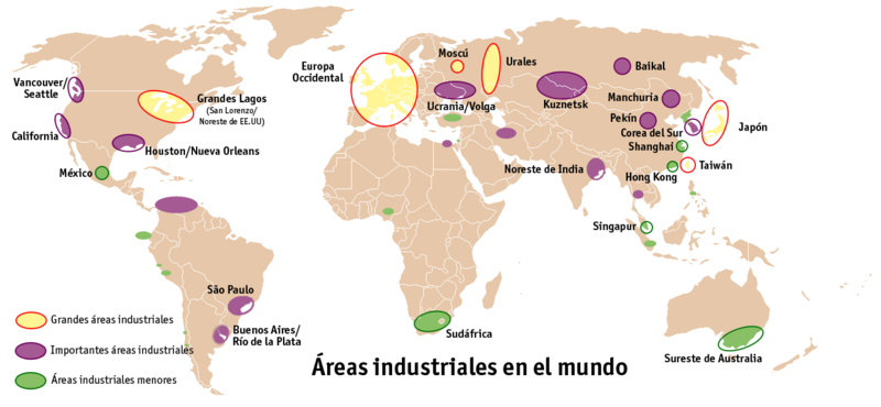
| Description | Mapa de situación de las áreas industriales en el mundo. Basado, nuevamente, en la imagen |
| Source | Image:BlankMap-World.png. Elaboración propia. |
| Author | User:Mortadelo2005 |
| Other versions |
|
Licensing[edit]

|
Permission is granted to copy, distribute and/or modify this document under the terms of the GNU Free Documentation License, Version 1.2 or any later version published by the Free Software Foundation; with no Invariant Sections, no Front-Cover Texts, and no Back-Cover Texts. A copy of the license is included in the section entitled GNU Free Documentation License. |
| This file is licensed under the Creative Commons Attribution-Share Alike 3.0 Unported license. | ||
| ||
| This licensing tag was added to this file as part of the GFDL licensing update. |
File history
Click on a date/time to view the file as it appeared at that time.
| Date/Time | Thumbnail | Dimensions | User | Comment | |
|---|---|---|---|---|---|
| current | 05:29, 12 December 2009 | | 1,357 × 628 (113 KB) | Garosuke (talk | contribs) | Se reescriben algunas zonas como centros de alta industrialización y otras como de industrialización media |
| 14:42, 1 November 2005 |  | 1,357 × 628 (138 KB) | Mortadelo2005 (talk | contribs) | Mapa de situación de las áreas industriales en el mundo. Basado, nuevamente, en la imagen [http://commons.wikimedia.org/wiki/Image:BlankMap-World.png Image:BlankMap-World.png]. Elaboración propia. Category:World maps |
You cannot overwrite this file.
File usage on Commons
There are no pages that use this file.
File usage on other wikis
The following other wikis use this file:
- Usage on an.wikipedia.org
- Usage on ar.wikipedia.org
- Usage on ca.wikipedia.org
- Usage on eo.wikipedia.org
- Usage on fa.wikipedia.org
- Usage on fi.wikipedia.org
- Usage on gl.wikipedia.org
- Usage on ja.wikipedia.org