Uploads by Rosemania
Jump to navigation
Jump to search
For Rosemania (talk · contributions · Move log · block log · uploads · Abuse filter log)
This special page shows all uploaded files that have not been deleted; for those see the upload log.
| Date | Name | Thumbnail | Size | Description |
|---|---|---|---|---|
| 08:12, 13 August 2018 | ADD Destinations.svg (file) |  |
1.17 MB | Add new destinations in Argentina, Eritrea, Russia, Switzerland. |
| 12:37, 25 September 2017 | Fly over Pamir Mountains and Karakoram Highway.jpg (file) |  |
1.67 MB | User created page with UploadWizard |
| 11:21, 25 September 2017 | Bridges across the Blue Nile Gorge.jpg (file) |  |
3.2 MB | User created page with UploadWizard |
| 08:59, 19 December 2016 | ET-ALO at ADD.jpg (file) |  |
1.5 MB | {{Information |Description ={{en|1=ET-ALO, Boeing 767-300ER tail detail }} |Source =Own Work |Author =Rosemania |Date =2016-12-11 |Permission = |other_versions = }} [[Category:Ethiopian Airlines (Sta... |
| 08:43, 19 December 2016 | ET 787 Dreamliner at ADD-HABB.jpg (file) |  |
1.24 MB | {{Information |Description ={{en|1=An Ethiopian Airlines Boeing 787-8 Dreamliner parked at Addis Ababa Bole International Airport.}} |Source =Own work |Author =Rosemania |Date =2016-12-04 |Permission... |
| 16:17, 12 December 2014 | NIH Building 10.jpg (file) |  |
324 KB | User created page with UploadWizard |
| 20:13, 2 January 2013 | JMW Turner - Modern Rome - Campo Vacino.jpg (file) |  |
2.47 MB | {{Information |Description ={{en|1=Joseph Mallord William Turner English, 1839 Oil on canvas 36 1/8 x 48 1/4 in. The J. Paul Getty Museum. Los Angeles, CA. <a href="http://www.getty.edu/art/gettyguide/artObjectDetails?artobj=324992" rel="nofoll... |
| 23:40, 10 April 2012 | China 1940 At War.JPG (file) |  |
5.54 MB | {{Information |Description ={{en|1="Reprinted from PM Monday, July 8, 1940" Includes a text "China: After Three Years of War." Shows areas under Chinese, Japanese, or guerilla control. Legend shows control of forces; railroads; highways; navigable r... |
| 00:47, 23 March 2012 | Zhejiang 1773-1820.jpg (file) |  |
10.16 MB | {{Information |Description ={{en|1=Map of Zhejiang (Zhejiang Quan Tu). Oriented with north to the bottom. Shows mountains, coastline, islands, and roads in Zhejiang Province. Pictorial map. Pen-and-ink and watercolor. }} {{zh-hant|1=浙江全圖... |
| 00:42, 23 March 2012 | Zhejiang 1773-1820 Qiantang.jpg (file) |  |
10.1 MB | {{Information |Description ={{en|1=Map of Hangzhou Bay (Hangzhou Wan Tu). Shows area along Qiantang River, especially the section of Hangzhou Bay in Zhejiang Province. Scale ca. 1:120,000. }} {{zh-hant|1=杭州灣圖}} |Source ={{LOC-map... |
| 00:26, 23 March 2012 | Hangzhou 1864-1874.jpg (file) |  |
7.79 MB | {{Information |Description ={{en|1=Map of Hangzhou, China (Zhejiang Sheng yuan fang xiang quan tu). Pictorial map. Oriented with north to the right. Pen-and-ink and watercolor. Scale ca. 1:7,000. }} {{zh-hant|1=浙江省垣房廂全圖}} |Sourc... |
| 00:22, 23 March 2012 | Hangzhou Waterway 1864-1874.jpg (file) |  |
16.6 MB | {{Information |Description ={{en|1=Map of the canals and rivers of Hangzhou, capital of Zhejiang, China. Zhejiang Sheng Yuan Shui Li Quan Tu Brush and ink on rice paper. Shows water supply of Hangzhou, capital of Zhejiang Province. Shows the area... |
| 23:53, 22 March 2012 | Zhejiang 1904-1911.jpg (file) |  |
22.73 MB | {{Information |Description ={{en|1=Map of the coastline of Zhejiang Province, China. Covers from Hangzhou Bay, Jiangsu to Oujiang, Wenzhou fu. Shows defense along coastal areas of Jiaxing, Hangzhou, Shaoxing, Ningbo, Taizhou, and Wenzhou. Relief ... |
| 23:34, 22 March 2012 | Hangzhou - West Lake 1759.jpg (file) |  |
2.09 MB | {{Information |Description ={{en|1=Map of West Lake, Hangzhou, China (Xihu Quan Tu).}} {{zh-hans|1=西湖全图}} |Source ={{LOC-map|id=g7823xm.gct00164 |division=gmd}} |Author =Unknown |Date =1759? |Permission = |other... |
| 23:33, 22 March 2012 | Hangzhou - River Wave 1759.jpg (file) |  |
2.1 MB | {{Information |Description ={{en|1=Autumn Waves of Zhejiang. (Zhejiang qiu tao)}} {{zh-hans|1=浙江秋涛图}} |Source ={{LOC-map|id=g7823xm.gct00164 |division=gmd}} |Author =Unknown |Date =1759? |Permission = |other_v... |
| 23:04, 20 March 2012 | Wuhan Hankow 1877.jpg (file) |  |
16.72 MB | {{Information |Description ={{en|1=Map of Hankow, China. Hubei Hankou zhen jie dao tu / Hubei guan shu ju bian zhi. [Hubei] : Fang si kan, Qing Guangxu 3 nian [1877] Scale 1:5,000. }} {{zh-hant|1=湖北漢口鎮街道圖。湖北官書局編制... |
| 23:00, 20 March 2012 | Wuhan Wuchang 1883.jpg (file) |  |
15.29 MB | {{Information |Description ={{en|1=Map of Wuchang, China : Hubei shan hou ju, Guangxu 9 nian [1883] Scale ca. 1:4,000. }} {{zh-hant|1=湖北省城內外街道總圖。光緒9年1883}} |Source ={{LOC-map|id=g7824w.ct002595 |division=gmd}} |A... |
| 22:56, 20 March 2012 | Wuhan 1864.jpg (file) |  |
26.58 MB | {{Information |Description ={{en|1=Map of Wuhan, China. Wuhan cheng zhen he tu / Hubei guan shu ju bian zhi. }} {{zh-hant|1=武漢城鎮合圖。湖北官書局編制}} |Source ={{LOC-map|id=g7824w.ct002594 |division=gmd}} |Author =H... |
| 20:08, 19 March 2012 | China Railroads 1961.jpg (file) |  |
4.37 MB | {{Information |Description ={{en|1=Communist China railroads and selected roads, June 1961. Includes inset of "Peiping and adjacent area." Scale [ca. 1:9,000,000] (E 660--E 1380/N 540--N 180).}} {{zh-hant|1=共產黨統治下中國鐵路圖,1961... |
| 20:02, 19 March 2012 | China 1933.jpg (file) |  |
5.03 MB | {{Information |Description ={{en|1=Zhonghua min guo fen sheng xin tu. (Map of Republic of China). Relief shown by hachures. Includes inset of Hainan Dao . Scale 1:12,413,400 (E 700--E 1400/N 500--N 200). }} {{zh-hant|1=中華民國分省新圖。... |
| 19:56, 19 March 2012 | Asia 1932.jpg (file) |  |
12.4 MB | {{Information |Description ={{en|1=Map featuring countries of the Far East.}} |Source ={{LOC-map|id=g7800.ct001989a|division=gmd}} |Author =Chicago : Geographical Publishing Co. |Date =1932 |Permission = |other_versions... |
| 19:40, 19 March 2012 | China 1689-1722 Frontier - Taiwan.jpg (file) |  |
14.45 MB | |
| 19:39, 19 March 2012 | China 1689-1722 Frontier - Russia.jpg (file) |  |
13.79 MB | |
| 19:39, 19 March 2012 | China 1689-1722 Frontier - Inner Mongolia.jpg (file) |  |
13.31 MB | |
| 19:39, 19 March 2012 | China 1689-1722 Frontier - Aihun.jpg (file) |  |
12.3 MB | |
| 22:01, 14 March 2012 | China 1929.jpg (file) |  |
14.24 MB | {{Information |Description ={{en|1=Zhong hua guo chi di tu. Map of the Shame of China. Includes tables showing treaties signed by China, and harbors opened for foreign powers. LC copy mounted on cloth backing. Scale 1:6,400,000.}} {{zh-hans|1=中... |
| 21:20, 14 March 2012 | China-World Map Ming front.jpg (file) |  |
4.76 MB | |
| 21:20, 14 March 2012 | China-World Map Ming back.jpg (file) |  |
4.91 MB | |
| 20:29, 13 March 2012 | China-Russia Frontier 1890 - Baikal.jpg (file) |  |
34.13 MB | |
| 20:29, 13 March 2012 | China-Russia Frontier 1890 - Xinjiang.jpg (file) |  |
23.02 MB | |
| 20:29, 13 March 2012 | China-Russia Frontier 1890 - Beijing.jpg (file) |  |
20.73 MB | |
| 20:29, 13 March 2012 | China-Russia Frontier 1890 - Amur Manchuria.jpg (file) |  |
31.96 MB | |
| 20:29, 13 March 2012 | China-Russia Frontier 1890 - Akmolinskaya.jpg (file) |  |
13.68 MB | |
| 20:29, 13 March 2012 | China-Russia Frontier 1890 - Pamir.jpg (file) |  |
9.7 MB | |
| 07:55, 5 March 2012 | Hangzhou-Haining 1765-1772.jpg (file) | 5.31 MB | {{Information |Description ={{en|1=Map of Hangzhou to Hanning, China. Covers the route from the Anlanyuan garden in Haining Zhou to the travel palace inside Hangzhou Fu, Zhejiang Province. Shows sluides, dikes, bridges, road, and military posts. ... | |
| 07:13, 5 March 2012 | Ningbo 1796-1820.jpg (file) |  |
22.14 MB | {{Information |Description ={{en|1=Map of Ningbo, China. Ning jun di yu tu.}} {{zh|1=宁郡地舆图}} |Source ={{LOC-map|id=g7824n.ct003081|division=gmd}} |Author =Unknown |Date =1796-1820 |Permission = |other_version... |
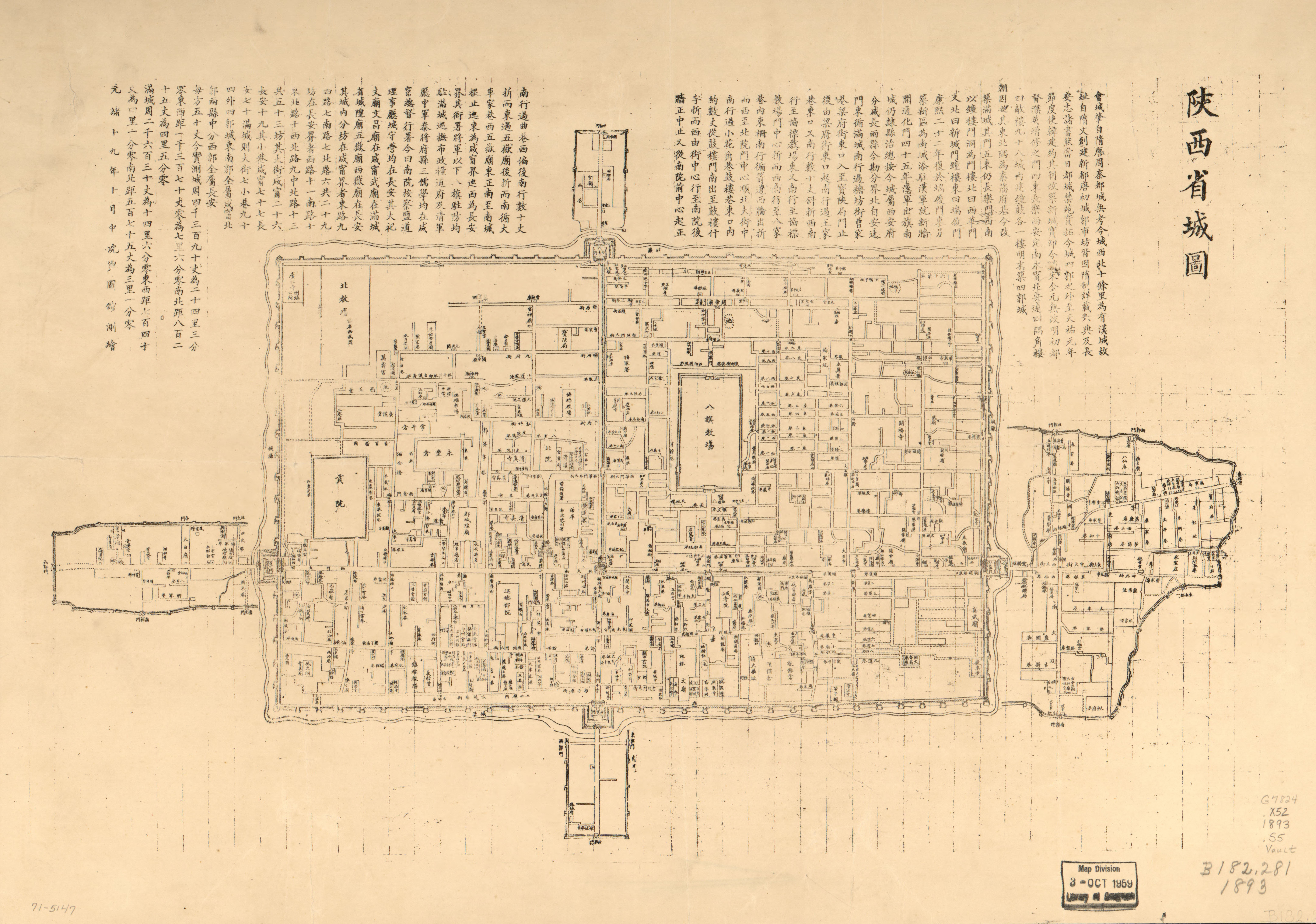
| 07:10, 5 March 2012 | Xi'an 1893.jpg (file) |  |
3.42 MB | {{Information |Description ={{en|1=Map of Xi'an, China. Shanxi sheng cheng tu / Shanxi Sheng yu tu guan ce hui. }} |Source ={{LOC-map|id=g7824x.ct003298 |division=gmd}} |Author =Unknown |Date =1893 |Permission = |othe... |
| 07:06, 5 March 2012 | Laizhou 1800-1850.jpg (file) |  |
3.02 MB | {{Information |Description ={{en|1=Map of Laizhou, Shandong, China. Laizhou fu Changyi xian cheng yuan tu. Scale ca. 1:5,000. Title from verso. Pictorial map. Pen-and-ink and watercolor. }} |Source ={{LOC-map|id=g7824c.ct003297|division=... |
| 06:54, 5 March 2012 | Liaoning 1882 - Shengjing.jpg (file) |  |
4.2 MB | |
| 06:54, 5 March 2012 | Liaoning 1882 Cities - Yalujiang.jpg (file) |  |
3.88 MB | |
| 06:54, 5 March 2012 | Liaoning 1882 Cities - Liaoyang.jpg (file) |  |
3.65 MB | |
| 06:54, 5 March 2012 | Liaoning 1882 Cities - Xinmintun.jpg (file) |  |
3.84 MB | |
| 06:54, 5 March 2012 | Liaoning 1882 Cities - Tieling.jpg (file) |  |
4.16 MB | |
| 22:43, 1 March 2012 | 1710 Nanyanbuzhou.jpg (file) |  |
12.82 MB | {{Information |Description ={{en|1=Nanzenbushu bankoku shoka no zu}} {{ja|1=南瞻部洲万国掌菓之図 浪華子製図并撰 文台軒宇平 宝永7(1710)年}} {{zh-hant|1=南瞻部洲萬國掌菓之圖}} |Source =David Rumsey Map Co... |
| 04:33, 1 March 2012 | China 1814-1816.jpg (file) |  |
75.85 MB | {{Information |Description ={{en|1=Da Qing Wan Nian Yi Tong Di Li Quan Tu (Map of Qing Dynasty's Eternal Rules) This map covers the area from Korea to Pamirs, from Heilongjiang river to the islands of the South China Sea. It shows the mountains, r... |
| 04:01, 1 March 2012 | Wutaishan 1846.jpg (file) |  |
70.62 MB | {{Information |Description ={{en|1=Wutai shan sheng jing quan tu (Map of Wutai Shan the Sacred Place). Shows panoramic view of Wutai Shan with the famous Buddhist monastery. Wood block print on linen, hand colored. Engraved by Gelonglongzhu Title... |
| 03:52, 1 March 2012 | Hainan 1820-1875.jpg (file) |  |
36.26 MB | {{Information |Description ={{en|1=Hainan Dao Tu Shuo (Illustrative Map of Hainan Island)}} |Source ={{LOC-map|id=g7823h.ct001457|division=gmd}} |Author =Unknown |Date =1820-1875 |Permission = |other_versions = }} [[Ca... |
| 03:10, 1 March 2012 | 2008 US Presidential election confounding ORWA.svg (file) |  |
262 KB | {{Information |Description ={{en|1=2008 Presidential election result and median household income by county. Oregon Washington.}} |Source ={{own}} |Author =Rosemania |Date =2012-02-29 |Permission = |ot... |
| 07:41, 29 February 2012 | Chengdu 1989 CIA.jpg (file) |  |
13.35 MB | {{Information |Description ={{en|1=Map of Chengdu, Sichuan. Purple for government/institutional land Orange for commercial/industrial Yellow for utility/transportation Green for park/vegetation Gray for densely populated area. }} |Source ... |
| 07:36, 29 February 2012 | Anyang County 1900-1910.jpg (file) |  |
33.65 MB | {{Information |Description ={{en|1=Anyang xian quan jing yu tu (Map of Anyang County) Scale [ca. 1:380,160]}} |Source ={{LOC-map|id=g7823a.ct003400 |division=gmd}} |Author =Unknown |Date =1900-1910 |Permission = |other... |