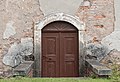
Category:House number 54 in Różanka
Jump to navigation
Jump to search
| Object location | | View all coordinates using: OpenStreetMap |
|---|
house in Poland  | |||||
| Upload media | |||||
| Instance of | |||||
|---|---|---|---|---|---|
| Location | Różanka, Lower Silesian Voivodeship, Gmina Międzylesie, Kłodzko County, Lower Silesian Voivodeship, Poland | ||||
| Heritage designation |
| ||||
| Inception |
| ||||
 | |||||
Media in category "House number 54 in Różanka"
The following 4 files are in this category, out of 4 total.
-
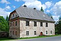 2014 Różanka, dom nr 54.jpg 3,155 × 2,120; 4.85 MB
-
 2017 Dom nr 54 w Różance 1.jpg 4,706 × 3,185; 9.83 MB
-
 2017 Dom nr 54 w Różance 2.jpg 4,898 × 3,227; 9.71 MB
-
 2017 Dom nr 54 w Różance 3.jpg 3,598 × 2,452; 6.28 MB


