File:Jacksonville Skyline Night Panorama Digon3.jpg
Jump to navigation
Jump to search

Size of this preview: 800 × 237 pixels. Other resolutions: 320 × 95 pixels | 640 × 190 pixels | 1,024 × 303 pixels | 1,280 × 379 pixels | 6,754 × 2,000 pixels.
Original file (6,754 × 2,000 pixels, file size: 5.1 MB, MIME type: image/jpeg)
Captions
Captions
Add a one-line explanation of what this file represents
Summary[edit]
This image has been assessed using the Quality image guidelines and is considered a Quality image.
|
| Description |
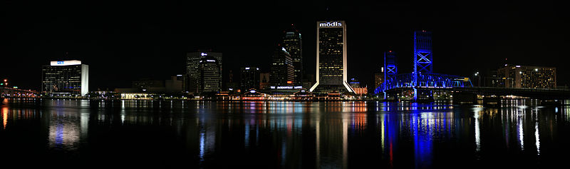
English: Panorama of the Jacksonville city skyline at night from across the St. Johns river in Jacksonville, Florida, USA. Jacksonville is the largest city in land area in the United States
Español: Panorama del horizonte de la ciudad de Jacksonville a través del río del St. Johns en Jacksonville, la Florida, los E.E.U.U..
Deutsch: Panorama des Jacksonville Stadt Skyline über vom Str. Johns Fluß in Jacksonville, Florida, USA.
Français : Vue panoramique du centre-ville de Jacksonville depuis l'autre rive du fleuve Saint Johns. Floride, États-Unis.
Nederlands: Panorama van de stadsskyline van Jacksonville van over de St. Johns rivier in Jacksonville, Florida, de V.S.. |
| Date | |
| Source | Own work |
| Author | “Jonathan Zander (Digon3)” |
| Other versions |
|
| Camera location | | View this and other nearby images on: OpenStreetMap |
|---|
Licensing[edit]
| ||||||
.png)

I, Jonathan Zander, the copyright holder of this work, hereby publishes it under the following licenses:

|
Permission is granted to copy, distribute and/or modify this document under the terms of the GNU Free Documentation License, Version 1.2 or any later version published by the Free Software Foundation; with no Invariant Sections, no Front-Cover Texts, and no Back-Cover Texts. A copy of the license is included in the section entitled GNU Free Documentation License. |
| This file is licensed under the Creative Commons Attribution-Share Alike 3.0 Unported license. | ||
| Attribution: I, Jonathan Zander | ||
| ||
| This licensing tag was added to this file as part of the GFDL licensing update. |
This file is licensed under the Creative Commons Attribution-Share Alike 2.5 Generic license.
Attribution: I, Jonathan Zander
- You are free:
- to share – to copy, distribute and transmit the work
- to remix – to adapt the work
- Under the following conditions:
- attribution – You must give appropriate credit, provide a link to the license, and indicate if changes were made. You may do so in any reasonable manner, but not in any way that suggests the licensor endorses you or your use.
- share alike – If you remix, transform, or build upon the material, you must distribute your contributions under the same or compatible license as the original.
You may select the license of your choice.
File history
Click on a date/time to view the file as it appeared at that time.
| Date/Time | Thumbnail | Dimensions | User | Comment | |
|---|---|---|---|---|---|
| current | 18:10, 20 February 2008 | 6,754 × 2,000 (5.1 MB) | Digon3 (talk | contribs) | {{Information |Description= |Source= |Date= |Author= |Permission= |other_versions= }} | |
| 15:42, 18 January 2008 | 6,597 × 1,557 (5.01 MB) | Digon3 (talk | contribs) | {{Information |Description= {{en|Panorama of the Jacksonville city skyline at night from across the St. Johns river in Jacksonville, Florida, USA. Jacksonville is the largest city in land area in the United States}}{{es|Panorama del horizonte de la ciudad |
You cannot overwrite this file.
File usage on Commons
The following 15 pages use this file:
- Jacksonville, Florida
- User:Digon3
- User:Digon3/Panoramas
- User talk:Digon3/Archive3
- Commons:Featured picture candidates/File:Jacksonville Skyline Night Panorama Digon3.jpg
- Commons:Featured picture candidates/Log/May 2009
- Commons:Photography critiques/2008 January
- Commons:Quality images/Subject/Architecture/Cityscapes/Archive
- Commons:Quality images candidates/Archives March 2008
- Commons talk:Quality images/Subject/Places/Man made structures
- File:Jacksonville Skyline Night Panorama 2 Digon3.jpg
- File:Jacksonville Skyline Panorama 2.jpg
- File:Jacksonville Skyline Panorama 3.jpg
- File:Jacksonville Skyline Panorama 4.jpg
- File:Jacksonville Skyline Panorama 5.jpg
File usage on other wikis
The following other wikis use this file:
- Usage on en.wikipedia.org
- Usage on fr.wikipedia.org