File:Tansania map-de.svg
Jump to navigation
Jump to search

Size of this PNG preview of this SVG file: 596 × 599 pixels. Other resolutions: 239 × 240 pixels | 477 × 480 pixels | 764 × 768 pixels | 1,019 × 1,024 pixels | 2,037 × 2,048 pixels | 2,064 × 2,075 pixels.
Original file (SVG file, nominally 2,064 × 2,075 pixels, file size: 3.15 MB)
Captions
Captions
Add a one-line explanation of what this file represents
| Description |
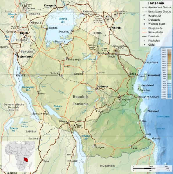
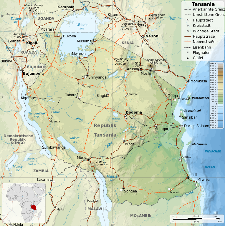
English: Map of Tanzania in French. Français : Carte de la Tanzanie en français. Español: Mapa de Tanzania en francés. Equirectangular projection. 1° N, 28° W, 42° E, -13° S. |
| Date | (UTC) |
| Source | |
| Author |
|
| Other versions |
[]
|


| This is a retouched picture, which means that it has been digitally altered from its original version. Modifications: Translation to german. The original can be viewed here: Tanzania map-fr.svg:
|
I, the copyright holder of this work, hereby publish it under the following license:
This file is licensed under the Creative Commons Attribution-Share Alike 3.0 Unported, 2.5 Generic, 2.0 Generic and 1.0 Generic license.
- You are free:
- to share – to copy, distribute and transmit the work
- to remix – to adapt the work
- Under the following conditions:
- attribution – You must give appropriate credit, provide a link to the license, and indicate if changes were made. You may do so in any reasonable manner, but not in any way that suggests the licensor endorses you or your use.
- share alike – If you remix, transform, or build upon the material, you must distribute your contributions under the same or compatible license as the original.
Original upload log
[edit]
This image is a derivative work of the following images:
- File:Tanzania_map-fr.svg licensed with Cc-by-sa-3.0,2.5,2.0,1.0, GFDL
- 2009-05-06T13:08:33Z Sémhur 2064x2075 (3304980 Bytes) smaller size (2/3)
- 2009-03-20T13:30:18Z Sémhur 3096x3113 (3225659 Bytes) Ol Doinyo Lengaï was misplaced
- 2009-03-20T11:14:35Z Sémhur 3096x3113 (3224368 Bytes) Add location map and few summits.
- 2009-03-19T17:14:13Z Sémhur 3096x3113 (3099209 Bytes) grrr...
- 2009-03-19T17:08:18Z Sémhur 3096x3113 (3099244 Bytes) Oups ! It wasn't the valid one.
- 2009-03-19T17:05:02Z Sémhur 3096x3113 (3122421 Bytes) {{Information |Description={{en|1=Map of [[:en:Tanzania]].}} {{fr|1=Carte de la [[:fr:Tanzanie]].}} {{es|1=Mapa de [[:es:Tanzania]].}} |Source=travail personnel (own work). Sources of data: * Elevations : NASA SRTM3 (public d
Uploaded with derivativeFX
File history
Click on a date/time to view the file as it appeared at that time.
| Date/Time | Thumbnail | Dimensions | User | Comment | |
|---|---|---|---|---|---|
| current | 13:32, 22 October 2009 | | 2,064 × 2,075 (3.15 MB) | Carl Steinbeißer (talk | contribs) | some translation mistakes: Mocambique to Mosambik Nil Blanc to Weißer Nil Ruandasee to Rukwasee |
| 10:40, 22 October 2009 |  | 2,064 × 2,075 (3.15 MB) | Carl Steinbeißer (talk | contribs) | {{Information |Description={{en|1=Map of Tanzania in French.}} {{fr|1=Carte de la Tanzanie en français.}} {{es|1=Mapa de Tanzania en francés.}} Equirectangular projection. 1° N, 28° W, 42° E, -13° S |
You cannot overwrite this file.
File usage on Commons
The following 16 pages use this file:
- File:Tansania map-de.svg
- File:Tanzania location map.svg
- File:Tanzania map-be.svg
- File:Tanzania map-bg.svg
- File:Tanzania map-en.svg
- File:Tanzania map-es.svg
- File:Tanzania map-fr.jpg
- File:Tanzania map-fr.svg
- File:Tanzania map-it.svg
- File:Tanzania map-mk.svg
- File:Tanzania map-nb.svg
- File:Tanzania map-ru.svg
- File:Tanzania map-sw.svg
- File:Tanzania map-uk.svg
- File:Tanzania relief location map.svg
- Template:Other versions/Maps of Tanzania
File usage on other wikis
The following other wikis use this file:
- Usage on als.wikipedia.org
- Usage on ca.wikipedia.org
- Usage on de.wikipedia.org