File:Ethnic map of 11th century.jpg: Difference between revisions
Jump to navigation
Jump to search
Content deleted Content added
Shortened, newlines (readibility) |
Fakirbakir (talk | contribs) UPLOAD YOUR OWN MAP , |
||
| Line 1: | Line 1: | ||
=={{int:filedesc}}== |
=={{int:filedesc}}== |
||
{{Information |
{{Information |
||
| ⚫ | |description={{en|1=Ethnic map of Kingdom of Hungary in the 11th century based on place-names. ''..."Although the historical study of place-names is not practised to the same extent in all countries, it is a recognized branch of historiography. It encompasses the etymology of geographical names as well as cultural and chronological variations in the naming of places. To facilitate their study of Hungarian place-names, István Kniezsa and Géza Bárczi developed an analytical framework that blends etymology, typology, and chronology. The validity of this triple approach has been amply demonstrated, thanks not only to the expertise of the two scholars but also to the peculiarity of Hungarian toponymy, which is readily distinguishable from that of any other culture. Most of the early Hungarian toponyms are derived from the names of people, clans, and ethnic groups, or from occupations, and used in the nominative case singular (e.g. Árpád, Megyer, Cseh [Czech], Ács [carpenter]). This type of toponymy appears in the earliest documents, dating from around 1000 AD. The pattern holds well into the 13th century — until the 1220s in western Hungary, and the 1270s in the eastern parts, including Transylvania..."''(László Makkai, [http://mek.oszk.hu/03400/03407/html/60.html TRANSYLVANIA IN THE MEDIEVAL HUNGARIAN KINGDOM (896–1526)], IN: Köpeczi Béla (General Editor), HISTORY OF TRANSYLVANIA Volume I. From the Beginnings to 1606, Distributed by Columbia University Press, New York, 2001, ISBN 0-88033-479-7)}} |
||
|description={{en|1=Interwar view on the ethnic composition of Kingdom of Hungary in the 11th century based on place-names (István Kniezsa and Lajos Glaser, 1938). The work was innovative at the time of publication, but the author did not prevent several mistakes (e.g. interpretation of names without Slavic suffixes as Hungarian) and misinterpreted the situation to the detriment of Slavic populations.<ref>Marek M.: Národnosti Uhorska [Nationalities in the Kingdom of Hungary], Trnava University, Trnava. ISBN 978-80-8082-470-9. (pages 39-40)</ref> The map is not compliant with later archeological research in Slovakia.<ref>Maslíková Ľ.: Vývoj osídlenia dolného Ponitria do polovice 14. storočia [Evolution of settlement of lower Ponitrie until 14th century] in Historia Nova I- 2010-2, Comenius University, Bratislava. ISBN 978-80-8127-118-2. (page 9)</ref> |
|||
| ⚫ | ''..."Although the historical study of place-names is not practised to the same extent in all countries, it is a recognized branch of historiography. It encompasses the etymology of geographical names as well as cultural and chronological variations in the naming of places. To facilitate their study of Hungarian place-names, István Kniezsa and Géza Bárczi developed an analytical framework that blends etymology, typology, and chronology. The validity of this triple approach has been amply demonstrated, thanks not only to the expertise of the two scholars but also to the peculiarity of Hungarian toponymy, which is readily distinguishable from that of any other culture. Most of the early Hungarian toponyms are derived from the names of people, clans, and ethnic groups, or from occupations, and used in the nominative case singular (e.g. Árpád, Megyer, Cseh [Czech], Ács [carpenter]). This type of toponymy appears in the earliest documents, dating from around 1000 AD. The pattern holds well into the 13th century — until the 1220s in western Hungary, and the 1270s in the eastern parts, including Transylvania..."''(László Makkai, [http://mek.oszk.hu/03400/03407/html/60.html TRANSYLVANIA IN THE MEDIEVAL HUNGARIAN KINGDOM (896–1526)], IN: Köpeczi Béla (General Editor), HISTORY OF TRANSYLVANIA Volume I. From the Beginnings to 1606, Distributed by Columbia University Press, New York, 2001, ISBN 0-88033-479-7)}} |
||
|date=2013-01-19 22:01:55 |
|date=2013-01-19 22:01:55 |
||
|source={{own}} |
|source={{own}} |
||
| Line 12: | Line 9: | ||
(The map is based on a public domain map: http://commons.wikimedia.org/wiki/File:Hungary_13th_cent.png) |
(The map is based on a public domain map: http://commons.wikimedia.org/wiki/File:Hungary_13th_cent.png) |
||
|author=[[User:Fakirbakir|Fakirbakir]] |
|author=[[User:Fakirbakir|Fakirbakir]] |
||
|permission= |
|permission= |
||
Revision as of 18:25, 10 June 2015
Captions
Captions
Add a one-line explanation of what this file represents
Summary
| Description |
English: Ethnic map of Kingdom of Hungary in the 11th century based on place-names. ..."Although the historical study of place-names is not practised to the same extent in all countries, it is a recognized branch of historiography. It encompasses the etymology of geographical names as well as cultural and chronological variations in the naming of places. To facilitate their study of Hungarian place-names, István Kniezsa and Géza Bárczi developed an analytical framework that blends etymology, typology, and chronology. The validity of this triple approach has been amply demonstrated, thanks not only to the expertise of the two scholars but also to the peculiarity of Hungarian toponymy, which is readily distinguishable from that of any other culture. Most of the early Hungarian toponyms are derived from the names of people, clans, and ethnic groups, or from occupations, and used in the nominative case singular (e.g. Árpád, Megyer, Cseh [Czech], Ács [carpenter]). This type of toponymy appears in the earliest documents, dating from around 1000 AD. The pattern holds well into the 13th century — until the 1220s in western Hungary, and the 1270s in the eastern parts, including Transylvania..."(László Makkai, TRANSYLVANIA IN THE MEDIEVAL HUNGARIAN KINGDOM (896–1526), IN: Köpeczi Béla (General Editor), HISTORY OF TRANSYLVANIA Volume I. From the Beginnings to 1606, Distributed by Columbia University Press, New York, 2001, ISBN 0-88033-479-7) |
| Date | |
| Source |
Own work Sources:
|
| Author | Fakirbakir |
Licensing
I, the copyright holder of this work, hereby publish it under the following license:
This file is licensed under the Creative Commons Attribution-Share Alike 3.0 Unported license.
- You are free:
- to share – to copy, distribute and transmit the work
- to remix – to adapt the work
- Under the following conditions:
- attribution – You must give appropriate credit, provide a link to the license, and indicate if changes were made. You may do so in any reasonable manner, but not in any way that suggests the licensor endorses you or your use.
- share alike – If you remix, transform, or build upon the material, you must distribute your contributions under the same or compatible license as the original.
File history
Click on a date/time to view the file as it appeared at that time.
| Date/Time | Thumbnail | Dimensions | User | Comment | |
|---|---|---|---|---|---|
| current | 22:22, 22 January 2013 | 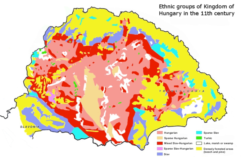 | 806 × 526 (236 KB) | Fakirbakir (talk | contribs) | minor changes (according to Kniezsa's map) |
| 17:15, 21 January 2013 |  | 806 × 526 (235 KB) | Fakirbakir (talk | contribs) | More understandable, repair, + I remove "Hungarian perspective" because other editors convinced me, science is universal, a scientific statement should not depend on the nationality of the scholar. | |
| 10:35, 21 January 2013 |  | 806 × 526 (232 KB) | Fakirbakir (talk | contribs) | More neutral / "Hungarian perspective" | |
| 22:08, 19 January 2013 |  | 806 × 526 (226 KB) | Fakirbakir (talk | contribs) | User created page with UploadWizard |
You cannot overwrite this file.
File usage on Commons
There are no pages that use this file.
File usage on other wikis
The following other wikis use this file:
- Usage on en.wikipedia.org
- Usage on eo.wikipedia.org
- Usage on hu.wikipedia.org
- Usage on uk.wikipedia.org