Uploads by DavidCane
Jump to navigation
Jump to search
For DavidCane (talk · contributions · Move log · block log · uploads · Abuse filter log)
This special page shows all uploaded files that have not been deleted; for those see the upload log.
| Date | Name | Thumbnail | Size | Description | Current version |
|---|---|---|---|---|---|
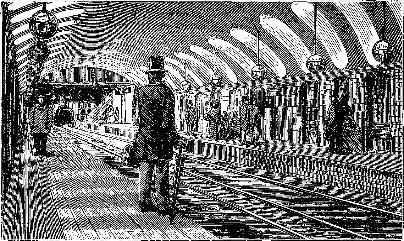
| 22:24, 31 January 2022 | Gower Street Station.png (file) |  |
81 KB | {{Information |Description="Fig. 50 - Gower Street Station, Metropolitan Railway", from page 115 of "Discoveries And Inventions of the Nineteenth Century", 13th Edition, by Robert Routledge. |Source= https://www.gutenberg.org/files/54475/54475-h/54475-h.htm |Date=1900 |Author=Artist of wood cut not recorded |Permission= |other_versions= }} =={{int:license-header}}== {{PD-US-expired}} Category:Project Gutenberg Category:Euston Square tube station | Yes |
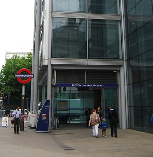
| 18:41, 29 January 2022 | Euston Square Station - geograph.org.uk - 2727745.jpg - crop.png (file) |  |
301 KB | == {{int:filedesc}} == {{Information |Description={{en|1=Euston Square Station}} |Source=From [https://www.geograph.org.uk/photo/2727745 geograph.org.uk] |Date=2011-06-10 |Author=[https://www.geograph.org.uk/profile/3101 N Chadwick] |Permission=Creative Commons Attribution Share-alike license 2.0 |Other fields={{Credit line |Author=N Chadwick |License=[https://creativecommons.org/licenses/by-sa/2.0/ CC BY-SA 2.0] |Other=''Euston Square Station'' }} }} {{Location|51.525247|-0.136132|source... | Yes |
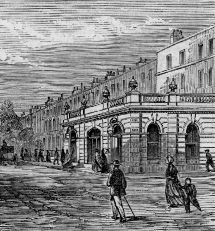
| 11:44, 29 January 2022 | Gower Street station entrance, 1862.png (file) |  |
615 KB | {{Information |Description=South entrance to Gower Street Metropolitan Railway station (now Euston Square), 1862 |Source=The Illustrated London News, Issue 1181, page 692 |Date=1862-12-27 |Author=Unknown (illegible) |Permission={{pd-old}}{{PD-old-auto-1923|1863}} |other_versions=extract of File:Metropolitan Underground Railway stations.jpg }} | Yes |
| 11:29, 29 January 2022 | Gower Street station map, 1895.png (file) |  |
1.07 MB | == {{int:filedesc}} == {{Information |Description=Gower Street Metropolitan Railway station (now Euston Square), Euston, London. |Source=Ordnance Survey map London VII.42 |Author={{unknown|Author}} |Date=Revised 1893-95, Published 1895 |Permission= |other_versions= }} {{OldOS}} | Yes |
| 11:32, 19 December 2021 | Holloway Cattle Dock.jpg (file) |  |
588 KB | == {{int:filedesc}} == {{Information |Description=Holloway Holloway Cattle Dock, Holloway, London. |Source=Ordnance Survey map TQ3085SE |Author={{unknown|Author}} |Date=Surveyed/Revised 1952, Published 1953 |Permission= |other_versions= }} {{OldOS}} Category:Holloway Car Dock | Yes |
| 22:36, 8 July 2021 | Stamford Brook Underground Station, Goldhawk Road W6 (geograph 5155848).jpg (file) | .jpg) |
104 KB | == {{int:filedesc}} == {{Information |Description={{en|1=Stamford Brook Underground Station, Goldhawk Road W6}} |Source=From [https://www.geograph.org.uk/photo/5155848 geograph.org.uk] |Date=2016-08-18 |Author=[https://www.geograph.org.uk/profile/13202 Robin Sones] |Permission=Creative Commons Attribution Share-alike license 2.0 |Other fields={{Credit line |Author=Robin Sones |License=[https://creativecommons.org/licenses/by-sa/2.0/ CC BY-SA 2.0] |Other=''Stamford Brook Underground Station... | Yes |
| 20:27, 4 July 2021 | London Traffic Area Map.png (file) |  |
267 KB | {{Information |Description=Map of the London Traffic Area specified in the London Traffic Act 1924 and area within which the London and Home Counties Traffic Advisory Committee had authority to advise the Minister of Transport on traffic matters. |Source=Simplified and redrawn from 1934 map "London Passenger Transport Board - Area of Operatio... | Yes |
| 22:11, 24 June 2021 | Boxley Abbey Barn.jpg (file) |  |
3.43 MB | {{Information |Description=Boxley Abbey Barn, Boxley, Kent |Source=Postcard |Date=circa 1910 |Author=Unknown |Permission={{PD-UK-unknown}} |other_versions= }} | Yes |
| 16:49, 20 June 2021 | John Jervis.png (file) |  |
983 KB | {{Information |Description=Sir John Jervis |Source=The London Journal, No. 145, Vol. VI. page 213. |Date=weekending 4 December 1847 |Author=unknown, unsigned |Permission={{PD-UK-unknown}} |other_versions= }} | Yes |
| 15:51, 20 June 2021 | Fitzroy Kelly.png (file) |  |
726 KB | {{Information |Description=Sir Fitzroy Kelly |Source=The London Journal, No. 140, Vol VI, page 141 |Date= Weekending 30 October 1847 |Author=unknown, unsigned |Permission={{PD-UK-unknown}} |other_versions= }} | Yes |
| 00:23, 19 June 2021 | Paddington Town Hall and Paddington Green.png (file) |  |
1.15 MB | first load failed | Yes |
| 00:21, 19 June 2021 | Paddington Town Hall and Paddington Green.png (file) | |
1.53 MB | {{Information |Description=Ordnance Survey map showing Paddington Town Hall, St Mary on Paddington Green Church and Paddington Green, London |Source=Map TQ2681NE |Date=Surveyed/Revised 1953, Published 1954 |Author=Ordnance Survey |Permission={{oldOS}} |other_versions= }} | No |
| 14:02, 15 May 2021 | Royal Commission on Metropolitan Termini Map.jpg (file) |  |
31.42 MB | Minor redraw to correct line on east side and tighten some of the corners | Yes |
| 23:06, 10 May 2021 | Royal Commission on Metropolitan Termini Map.jpg (file) | |
31.1 MB | {{Information |Description=Map of the area in London specified in 1846 by the Royal Commission on Metropolitan Termini into which railway lines and termini could not encroach. |Source=Base Map: Extract from "London" published by Baldwin & Craddock. |Date=Base Map: 1836 |Author=Map: J Henshall (engraver and printer). Outline: DavidCane based on description contained Royal Commission's report |Permission= |other_versions=[[File:1836 map of Lon... | No |
| 22:24, 31 October 2020 | Piccadilly Line.svg (file) |  |
27 KB | Correct spelling of "Piccadilly" | Yes |
| 10:54, 3 September 2020 | Royal Commission on London Traffic - Tramway Improvements.png (file) |  |
4.95 MB | == {{int:filedesc}} == {{Information |description=Tram routes recommended for improvement in the report of the Royal Commission on London Traffic, 1903 - See article for Description of routes indicated. |date= |source=Base Map: Stanford's Outer London Map, 1901. Routes: As described in Report |author=DavidCane |permission= |other versions= }} == {{int:license-header}} == {{self|GFDL... | Yes |
| 10:32, 3 September 2020 | Stepney Green Park.jpg (file) |  |
327 KB | {{Information |description=Stepney Green Park, London |date=3 September 2020 |source=Open Street Map |author= Open Street Map |permission={{CC-BY-SA-2.0}} and Open Street Map licence |other versions= }} Category:OpenStreetMap maps of London | No |
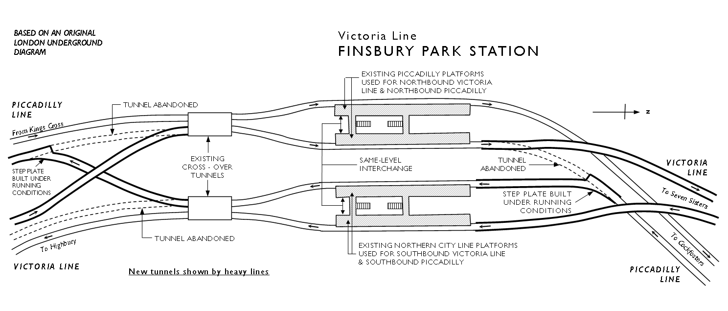
| 18:53, 21 June 2020 | Finsbury Park station Platform Changes.png (file) |  |
44 KB | {{Information |Description=Plan layout of Finsbury Park Underground station on the London Underground showing the changes made to the station when the Victoria line was constructed. |Source=redrawn from original diagram produced by London Transport Board in 1964. |Date=original 1964 |Author=User:DavidCane |Permission=As LTB was a government owned company its work would be subject to [[w:C... | Yes |
| 20:56, 2 June 2020 | Wimbledon Station entrance geograph-4072099-by-Ben-Brooksbank.jpg (file) |  |
1.71 MB | Colour correct over saturated image | Yes |
| 22:10, 7 May 2020 | Charing Cross Underground Station (geograph 5963644).jpg (file) | .jpg) |
144 KB | Transferred from geograph.co.uk using [https://tools.wmflabs.org/geograph2commons/ geograph2commons] | Yes |
| 00:43, 6 May 2020 | Charing Cross station, Jubilee line platform 05 (crop).jpg (file) | .jpg) |
1.05 MB | == {{int:filedesc}} == {{Information |Description= {{en|Charing Cross tube station, Jubilee line platforms}} {{pl|Stacja metra Charing Cross, linia Jubilee}} |Source={{own}} |Date=2015-07-05 |Author=Paweł 'pbm' Szubert (talk) |Permission={{user:pbm/Credits}} |other_versions=thumb }} {{Location dec|51.508182|-0.12514803333333333}} == {{int:license-header}} == {{self|cc-by-sa-4.0|GFDL}} [[Category:Char... | Yes |
| 16:46, 2 May 2020 | Royal Commission on London Traffic - Road Impovements.png (file) |  |
6.86 MB | Try a crop using different editing software | Yes |
| 13:51, 2 May 2020 | Royal Commission on London Traffic - Road Impovements.png (file) | |
9.73 MB | revert previous defective upload | No |
| 13:48, 2 May 2020 | Royal Commission on London Traffic - Road Impovements.png (file) | |
10.44 MB | a tighter crop to make it easier to read the reference letters at a smaller image size | No |
| 23:44, 29 April 2020 | Royal Commission on London Traffic - Road Impovements.png (file) | |
9.73 MB | {{Information |description=Routes recommended for improvement in the report of the Royal Commission on London Traffic, 1903 |date= |source=Base Map: Stanford's Outer London Map, 1901. Routes: As described in Report |author=DavidCane |permission= |other versions= }} | No |
| 18:03, 26 April 2020 | Extract from Report to the Minister of War Transport 21 January 1946 Map 1 Showing central area.jpg (file) | 175 KB | == {{int:filedesc}} == {{Information |Description=Extract from Map 1 from report, showing proposed new rail routes for The County of London Plan 1943 |Source=''Report to the Minister of War Transport, 21 January 1946'' |Date=1946-01-21 |Author=Railway (London Plan) Committee 1944 - Chairman Charles Inglis |Permission= |other_versions=thumb }} {{PD-UKGov}} [[Category:Railway (London Plan... | Yes | |
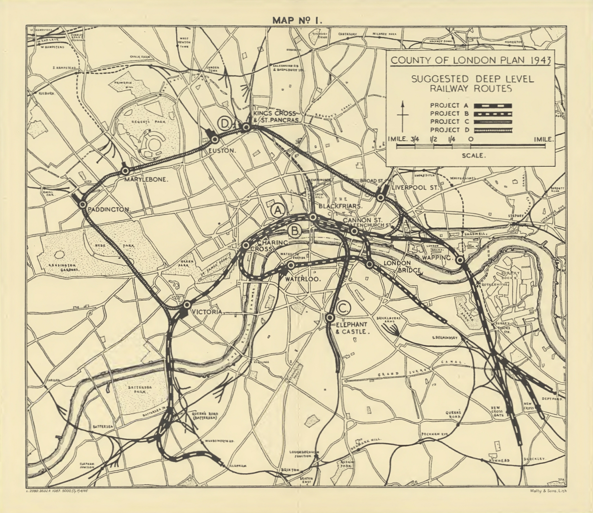
| 09:51, 26 April 2020 | Report to the Minister of War Transport 21 January 1946 Map 1.jpg (file) | 2.6 MB | == {{int:filedesc}} == {{Information |Description=Map 1 from report, showing proposed new rail routes for London area, 1946 |Source=''Report to the Minister of War Transport, 21 January 1946'' |Date=1946-01-21 |Author=Railway (London Plan) Committee 1944 - Chairman Charles Inglis |Permission= |other_versions= }} {{PD-UKGov}} Category:Rail transport maps of London | Yes | |
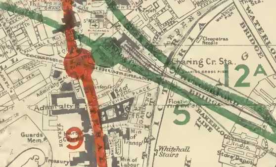
| 22:58, 25 April 2020 | Extract from Report to the Minister of War Transport 21 January 1946 Map 3 - Charing Cross Area.jpg (file) | 172 KB | crop top edge to remove part of Route 4 not relevant to the usage of this map | Yes | |
| 22:53, 25 April 2020 | Extract from Report to the Minister of War Transport 21 January 1946 Map 3 - Charing Cross Area.jpg (file) | 196 KB | == {{int:filedesc}} == {{Information |Description=Extract from Map 3 from report, showing proposed new rail routes in Charing Cross area |Source=''Report to the Minister of War Transport, 21 January 1946'' |Date=1946-01-21 |Author=Railway (London Plan) Committee 1944 - Chairman Charles Inglis |Permission= |other_versions=thumb }} {{PD-UKGov}} Category:Rail transport maps of London [... | No | |
| 22:47, 25 April 2020 | Report to the Minister of War Transport 21 January 1946 Map 3.png (file) | 50.3 MB | {{Information |Description=Map 3 from report, showing proposed new rail routes for London area, 1946 |Source=''Report to the Minister of War Transport, 21 January 1946'' |Date=1946-01-21 |Author=Railway (London Plan) Committee 1944 - Chairman Charles Inglis |Permission= |other_versions= }} {{PD-UKGov}} Category:London Underground maps Category:Rail transport maps of London | Yes | |
| 17:11, 25 April 2020 | Extract from Report to the Minister of War Transport 21 January 1946 Map 2 - Central Area.jpg (file) | 187 KB | {{Information |Description=Extract from Map 2 from report, showing proposed new rail routes in central London |Source=''Report to the Minister of War Transport, 21 January 1946'' |Date=1946-01-21 |Author=Railway (London Plan) Committee 1944 - Chairman Charles Inglis |Permission= |other_versions=thumb }} {{PD-UKGov}} Category:Rail transport maps of London [[Category:London Undergroun... | Yes | |
| 22:07, 21 April 2020 | Dr. Charles Holden, architect, 1946 (crop).jpg (file) | .jpg) |
44 KB | == {{int:filedesc}} == {{Information |Description= Dr. {{c|Charles Holden}}, 1946 |Source= crop of File:Dr. Charles Holden, architect, 1946.jpg |Date=1946-07 |Author= Photographer not credited |Permission= |other_versions=thumb }} =={{int:license-header}}== {{PD-US-not renewed}} Category:Architect and engineer (1946) Category:Charles Holden Category:1946 portrait photographs of men | Yes |
| 23:30, 16 April 2020 | London Ringways Plan.svg (file) |  |
223 KB | == {{int:filedesc}} == {{Information |Description={{en|*London Ringways Plan from the late 1960s showing roads planned for Ringways 1, 2, 3 and 4 indicating those sections of roads that were built and those sections not built. |Source= |Date=17/04/2020 |Author=DavidCane |Permission= |other_versions=thumb|File:London Ringways Plan.png == {{int:li... | Yes |
| 00:35, 16 April 2020 | Charing Cross Map 1902.png (file) |  |
9.28 MB | == {{int:filedesc}} == {{Information |description=Map showing locations of stations proposed in 1902 in parliamentary bills for underground stations in the Charing Cross area. |date=Revised 1893 to 1895. Edition Published 1894 to 1896 |source=Base Map Ordnance Survey map: London VII.SW. Station locations: as described in London's Lost Tube Schemes by Antony Badsey-Ellis |author={{unknown|author}} |permission= |other versions= }} {{OldOS}} [[Category:Charing Cross tube sta... | Yes |
| 00:34, 16 April 2020 | Charing Cross Map 1901.png (file) |  |
9.33 MB | == {{int:filedesc}} == {{Information |description=Map showing locations of stations proposed in 1901 in parliamentary bills for underground stations in the Charing Cross area. |date=Revised 1893 to 1895. Edition Published 1894 to 1896 |source=Base Map Ordnance Survey map: London VII.SW. Station locations: as described in London's Lost Tube Schemes by Antony Badsey-Ellis |author={{unknown|author}} |permission= |other versions= }} {{OldOS}} [[Category:Charing Cross tube sta... | Yes |
| 00:33, 16 April 2020 | Charing Cross Map 1890s.png (file) |  |
9.3 MB | == {{int:filedesc}} == {{Information |description=Map showing locations of stations proposed in the 1890s in parliamentary bills for underground stations in the Charing Cross area. |date=Revised 1893 to 1895. Edition Published 1894 to 1896 |source=Base Map Ordnance Survey map: London VII.SW. Station locations: as described in London's Lost Tube Schemes by Antony Badsey-Ellis |author={{unknown|author}} |permission= |other versions= }} {{OldOS}} [[Category:Charing Cross tub... | Yes |
| 00:32, 16 April 2020 | Charing Cross Map 1860s-1870s.png (file) |  |
9.3 MB | == {{int:filedesc}} == {{Information |description=Map showing locations of stations proposed in the 1860s and 1870s in parliamentary bills for underground stations in the Charing Cross area. |date=Revised 1893 to 1895. Edition Published 1894 to 1896 |source=Base Map Ordnance Survey map: London VII.SW. Station locations: as described in London's Lost Tube Schemes by Antony Badsey-Ellis |author={{unknown|author}} |permission= |other versions= }} {{OldOS}} [[Category:Charing... | Yes |
| 00:31, 16 April 2020 | Charing Cross Map 1880s.png (file) |  |
9.36 MB | == {{int:filedesc}} == {{Information |description=Map showing locations of stations proposed in the 1880s in parliamentary bills for underground stations in the Charing Cross area. |date=Revised 1893 to 1895. Edition Published 1894 to 1896 |source=Base Map Ordnance Survey map: London VII.SW. Station locations: as described in London's Lost Tube Schemes by Antony Badsey-Ellis |author={{unknown|author}} |permission= |other versions= }} {{OldOS}} [[Category:Charing Cross tub... | Yes |
| 14:33, 13 April 2020 | London Ringways Plan.png (file) |  |
1.75 MB | Change colour of the Ringway 4 section around Leatherhead from green to blue. Been meaning to do this for years. | Yes |
| 12:59, 13 April 2020 | Edgware stations, 1937.jpg (file) |  |
640 KB | == {{int:filedesc}} == {{Information |description=Map showing London and North Eastern Railway's Edgware station (bottom) and London Underground's Edgware station (top). |date=Revised 1935. Published 1937 |source=Ordnance Survey map: Middlesex VI.13 |author=unknown |permission= |other versions= }} {{OldOS}} | Yes |
| 10:46, 13 April 2020 | Mill Hill and The Hale stations, 1913.jpg (file) |  |
669 KB | == {{int:filedesc}} == {{Information |description=Map showing Midland Railway's Mill Hill station (now Mill Hill Broadway) and Great Northern Railway's The Hale station (later Mill Hill (The Hale)). |date=Revised 1911. Published 1913 |source=Ordnance Survey map: Middlesex VI.14 |author=unknown |permission= |other versions= }} {{OldOS}} | Yes |
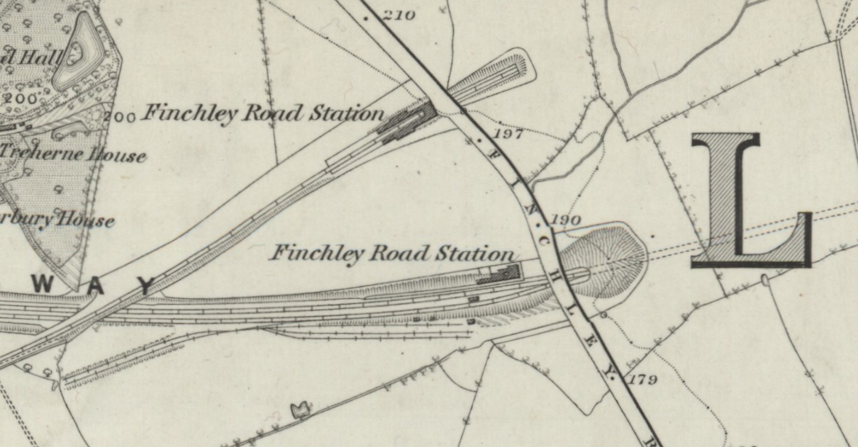
| 19:04, 28 March 2020 | Proposed site for Metropolitan and St John's Wood Railway's Finchley Road station.jpg (file) |  |
282 KB | == {{int:filedesc}} == {{Information |description=Map showing approximate location of Metropolitan and St John's Wood Railway's proposed station at Finchley Road on 1870 Ordnance Survey map. |date=2020-03-28 |source=Background map: Ordnance Survey map: London VII surveyed 1866, published 1870<br> Station location as described in Metropolitan and St Jo... | Yes |
| 18:47, 28 March 2020 | Finchley Road stations, 1870.jpg (file) |  |
393 KB | == {{int:filedesc}} == {{Information |description=London and North Western Railway's Finchley Road station (top) and Midland Railway's Finchley Road station (bottom) on 1870 Ordnance Survey map. |source=Ordnance Survey map: London VII surveyed 1866, published 1870 |author=unknown |permission= |other versions= }} {{OldOS}} {{Cc-by-... | Yes |
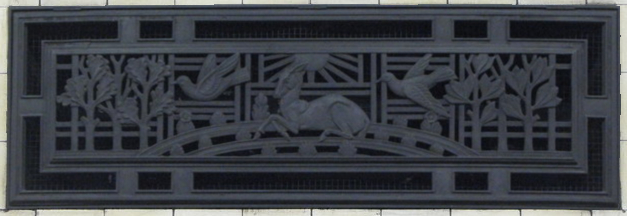
| 23:09, 17 March 2020 | Ventilation panel, Manor House tube station - geograph.org.uk - 1401124.jpg (file) |  |
136 KB | Crop | Yes |
| 23:05, 17 March 2020 | Ventilation panel, Wood Green tube station - geograph.org.uk - 1401101.jpg (file) |  |
115 KB | Crop | Yes |
| 15:56, 15 March 2020 | Lord's tube station on map.jpg (file) |  |
623 KB | {{Information |description=St John's Wood station on the Metropolitan Railway, later known as "St. John's Wood" (1925-39) and finally "Lords" (1939). |date=Revised 1893, published 1896 |source=Ordnance Survey Map: London (edition of 1894-96) Sheet XLVIII |author=unknown |permission= |other versions= }} {{OldOS}} | Yes |
| 15:31, 15 March 2020 | Metropolitan and St John's Wood Railway, circa 1867.jpg (file) |  |
746 KB | {{Information |Description=Extract from Metropolitan Railway of routes shows the Metropolitan and St John's Wood Railway then being constructed from Baker Street to Hampstead (opened from Baker Street to Swiss Cottage in 1868) |Source= |date= circa 1867 (based on lines open... | Yes |
| 15:07, 15 March 2020 | Metropolitan Railway Map, c 1867.jpg (file) |  |
5.84 MB | {{Information |description=Map of London showing the Metropolitan Railway with open routes and routes under construction. Shows Metropolitan Railway extensions under construction from Edgware Road to South Kensington (opened 1868) and from Moorgate to Mark Lane (opened in stages between 1875 and 1882... | Yes |
| 19:03, 8 March 2020 | Brentford, 1856 map.jpg (file) |  |
86 KB | {{Information |description=Brentford to the west of London where the River Brent meets the River Thames. |date=1856 |source=Ordance Survey Map First Series, Sheet 7 |author=N/A |permission= |other versions= }} {{OldOS}} | Yes |
| 23:37, 3 March 2020 | Brentford Dock Map, 1960.jpg (file) |  |
462 KB | == {{int:filedesc}} == {{Information |Description=Brentford Dock on an Ordnance Survey Map, 1960. |Source=Ordnance Survey, TQ17 NE Greater London |Author={{unknown|Author}} |Date=Surveyed: 1959-61, Published: 1966 |Permission= |other_versions= }} {{OldOS}} | Yes |