Category:Église Notre-Dame de Boissy-Lamberville
Jump to navigation
Jump to search
| Object location | | View all coordinates using: OpenStreetMap |
|---|
church located in Eure, in France  | |||||
| Upload media | |||||
| Instance of | |||||
|---|---|---|---|---|---|
| Location | Boissy-Lamberville, canton of Thiberville | ||||
| Diocese | |||||
| Religion or worldview | |||||
| Adjacent building | |||||
 | |||||
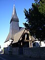
English: The Church Notre-Dame of Boissy-Lamberville (Eure, Haute-Normandie) in France was built in the 12th century. Church, cemetery, house of the brotherhood of charity and the yew trees are classified as "site classé", one of the labels of French heritage protection.
Deutsch: Die Kirche Notre-Dame von Boissy-Lamberville (Eure, Haute-Normandie) in Frankreich wurde im 12. Jahrhundert errichtet. Kirche, Friedhof, das Haus der Bruderschaft der Barmherzigkeit und die Eiben sind als "site classé" denkmalgeschützt.
Français : L'église Notre-Dame à Boissy-Lamberville dans l'Eure remonte au XIIe siècle. Le site d'église, cimetière et muret, chambre de charité et des ifs est classé.
Media in category "Église Notre-Dame de Boissy-Lamberville"
The following 14 files are in this category, out of 14 total.
-
 Boissy-Lamberville (Eure, Fr) église Notre-Dame (1).JPG 4,320 × 3,240; 5.38 MB
-
 Boissy-Lamberville (Eure, Fr) église Notre-Dame (2).JPG 3,240 × 4,320; 4.87 MB
-
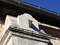 Boissy-Lamberville cadran solaire.jpg 2,576 × 1,932; 1.47 MB
-
 Boissy-Lamberville cimetière.jpg 1,928 × 2,576; 1.92 MB
-
 Boissy-Lamberville if.jpg 2,576 × 1,932; 1.77 MB
-
 Boissy-Lamberville plaque tombale.jpg 1,879 × 2,541; 2.33 MB
-
 Boissy-Lamberville plaques tombales.jpg 2,545 × 1,879; 2 MB
-
 Boissy-Lamberville porche d'église.jpg 1,928 × 2,576; 1.36 MB
-
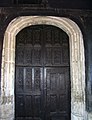 Boissy-Lamberville porte d'église.jpg 1,863 × 2,433; 1.71 MB
-
 Boissy-Lamberville sepulture.jpg 1,928 × 2,576; 1.97 MB
-
 Boissy-Lamberville église Notre-Dame.jpg 2,335 × 1,932; 1.45 MB
-
 Boissy-Lamberville église Notre-Dame2.jpg 2,576 × 1,736; 1.29 MB
-
 Boissy-Lamberville église vitre.jpg 1,889 × 2,555; 2.01 MB
-
 Boissy-Lamberville église.jpg 1,928 × 2,576; 1.41 MB
_%C3%A9glise_Notre-Dame_(1).JPG)
_%C3%A9glise_Notre-Dame_(2).JPG)


