Category:35 Wspólna Street in Warsaw
Jump to navigation
Jump to search
| Object location | | View all coordinates using: OpenStreetMap |
|---|
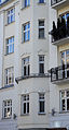
Polski: Warszawa, ul. Wspólna 35 - kamienica
 | |||||
| Upload media | |||||
| Instance of |
| ||||
|---|---|---|---|---|---|
| Location | Śródmieście, Warsaw, Masovian Voivodeship, Poland | ||||
| Street address |
| ||||
| Heritage designation |
| ||||
| Inception |
| ||||
| Significant event |
| ||||
 | |||||
Media in category "35 Wspólna Street in Warsaw"
The following 2 files are in this category, out of 2 total.
-
 Warszawa - Wspólna 35 - ZJ001.jpg 2,490 × 4,038; 1.04 MB
-
 Warszawa - Wspólna 35 - ZJ002.jpg 2,226 × 4,128; 949 KB
