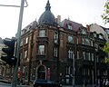
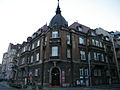
Category:50 Matejki Street in Poznań
Jump to navigation
Jump to search
| Object location | | View all coordinates using: OpenStreetMap |
|---|
 | |||||
| Upload media | |||||
| Instance of | |||||
|---|---|---|---|---|---|
| Location | Poznań, Greater Poland Voivodeship, Poland | ||||
| Street address |
| ||||
| Heritage designation |
| ||||
| Inception |
| ||||
| Significant event |
| ||||
 | |||||
Polski: Poznań ul. Matejki 50 - kamienica
Media in category "50 Matejki Street in Poznań"
The following 5 files are in this category, out of 5 total.
-
 Kamienica Matejki 50 Poznan detal.jpg 1,815 × 2,799; 2.17 MB
-
 Kamienica Matejki 50 Poznan.jpg 3,100 × 2,085; 3.21 MB
-
 Matejki 50 (1).JPG 2,662 × 2,136; 1.08 MB
-
 Matejki 50.JPG 2,770 × 2,130; 731 KB
-
 Poznań, kamienica, 1905-1906 Matejki-50.JPG 3,648 × 2,736; 1.8 MB


.JPG)
