Category:69 Church Street, 2 & 4 Parker Street, Liverpool
Jump to navigation
Jump to search
| Object location | | View all coordinates using: OpenStreetMap |
|---|
building in Liverpool, Merseyside, England, UK  | |||||
| Upload media | |||||
| Instance of | |||||
|---|---|---|---|---|---|
| Location | Liverpool, Merseyside, North West England, England | ||||
| Street address |
| ||||
| Heritage designation |
| ||||
 | |||||
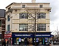
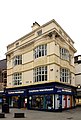
Grade II listed shop, late 19th century, at 69 Church Street and 2 & 4 Parker Street.
Media in category "69 Church Street, 2 & 4 Parker Street, Liverpool"
The following 11 files are in this category, out of 11 total.
-
 69 Church Street, Liverpool 1.jpg 4,075 × 3,204; 7.16 MB
-
 69 Church Street, Liverpool 2.jpg 3,161 × 4,696; 6.29 MB
-
 69 Church Street, Liverpool.jpg 3,236 × 4,496; 6.46 MB
-
 Carphone Warehouse in Liverpool 2.jpg 3,872 × 2,592; 2.2 MB
-
 Carphone Warehouse in Liverpool 3.jpg 3,872 × 2,592; 2.44 MB
-
 Carphone Warehouse in Liverpool 4.jpg 2,592 × 3,872; 2.02 MB
-
 Carphone Warehouse in Liverpool 5.jpg 2,592 × 3,872; 2.04 MB
-
 Carphone Warehouse in Liverpool 6.jpg 3,872 × 2,592; 2.43 MB
-
 Carphone Warehouse in Liverpool.jpg 3,872 × 2,592; 2.36 MB
-
 Carphone Warehouse Liverpool centre - geograph.org.uk - 1617425.jpg 640 × 480; 61 KB
-
 Liverpool, UK - panoramio - IIya Kuzhekin (17).jpg 4,000 × 3,000; 2.8 MB


.jpg)