Category:Alignement de menhirs de Poul-ar-Varquez
Jump to navigation
Jump to search
| Object location | | View all coordinates using: OpenStreetMap |
|---|
|
This building is inscrit au titre des monuments historiques de la France. It is indexed in the base Mérimée, a database of architectural heritage maintained by the French Ministry of Culture, under the reference PA00089432
|
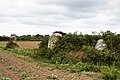
stone row in Pleubian, France  | |||||
| Upload media | |||||
| Instance of | |||||
|---|---|---|---|---|---|
| Location | Pleubian, canton of Lézardrieux | ||||
| Heritage designation |
| ||||
 | |||||
Media in category "Alignement de menhirs de Poul-ar-Varquez"
The following 4 files are in this category, out of 4 total.
-
 Alignement de menhirs de Poul-ar-Varquez.JPG 4,320 × 3,240; 3.06 MB
-
 Alignement Poul-ar-Varquez (Pleubian)-cd01.jpg 5,260 × 3,505; 12.56 MB
-
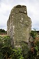 Menhir Poul-ar-Varquez (Pleubian)-cd01.jpg 3,505 × 5,260; 16.15 MB
-
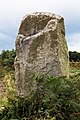 Menhir Poul-ar-Varquez (Pleubian)-cd02.jpg 3,505 × 5,260; 17.24 MB
-cd01.jpg)
-cd01.jpg)
-cd02.jpg)