Category:Alignement de Lutry
Jump to navigation
Jump to search
| Object location | | View all coordinates using: OpenStreetMap |
|---|
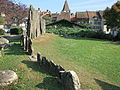
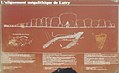
megalithic site in Lutry in the canton of Vaud, Switzerland  | |||||
| Upload media | |||||
| Instance of | |||||
|---|---|---|---|---|---|
| Part of |
| ||||
| Location | Lutry, Lavaux-Oron District, canton Vaud, Switzerland | ||||
| Street address |
| ||||
| Heritage designation | |||||
 | |||||
Media in category "Alignement de Lutry"
The following 7 files are in this category, out of 7 total.
-
 Lutry menhir1.JPG 1,000 × 667; 241 KB
-
 Lutry Menhire 01.JPG 4,000 × 3,000; 4.59 MB
-
 Lutry Menhire 02.JPG 4,000 × 3,000; 4.07 MB
-
 Lutry Menhire 03.JPG 3,000 × 4,000; 3 MB
-
 Lutry Menhire 04.JPG 4,000 × 3,000; 4.91 MB
-
 Lutry Menhire 05.JPG 4,000 × 3,000; 2.33 MB
-
 Lutry Menhire 06.JPG 3,384 × 2,067; 1.01 MB


