Category:All Saints Church, South Cerney
Jump to navigation
Jump to search
| Object location | | View all coordinates using: OpenStreetMap |
|---|
church in South Cerney, Gloucestershire, England  | |||||
| Upload media | |||||
| Instance of | |||||
|---|---|---|---|---|---|
| Dedicated to | |||||
| Location | South Cerney, Cotswold, Gloucestershire, South West England, England | ||||
| Diocese | |||||
| Heritage designation |
| ||||
| Inception |
| ||||
| Religion or worldview | |||||
 | |||||
Media in category "All Saints Church, South Cerney"
The following 4 files are in this category, out of 4 total.
-
 All Hallows Church, South Cerney, Gloucestershire.jpg 1,512 × 2,016; 1.41 MB
-
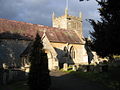 All Saints Church South Cerney - geograph.org.uk - 128834.jpg 640 × 480; 84 KB
-
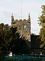 All Saints church tower, South Cerney - geograph.org.uk - 1518001.jpg 480 × 640; 162 KB
-
 The English village church - exteriors and interiors (1921) (14763349125).jpg 3,136 × 1,836; 727 KB


_(14763349125).jpg)