Category:Allée couverte de Kerantiec
Jump to navigation
Jump to search
|
This building is classé au titre des monuments historiques de la France. It is indexed in the base Mérimée, a database of architectural heritage maintained by the French Ministry of Culture, under the reference PA00090396
|
| Object location | | View all coordinates using: OpenStreetMap |
|---|
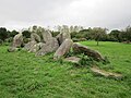
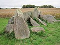
gallery grave in Riec-sur-Bélon, France  | |||||
| Upload media | |||||
| Instance of | |||||
|---|---|---|---|---|---|
| Location | Riec-sur-Bélon, Finistère, Brittany, Q88521114, Metropolitan France, France | ||||
| Heritage designation |
| ||||
 | |||||
Media in category "Allée couverte de Kerantiec"
The following 3 files are in this category, out of 3 total.
-
 002 Riec-sur-Belon Allée couverte Kerantiec.jpg 1,600 × 1,200; 716 KB
-
 003 Riec-sur-Belon Allée couverte Kerantiec.jpg 1,600 × 1,200; 865 KB
-
 Allée couverte Kerantiec.JPG 4,320 × 3,240; 4.77 MB

