Category:Allée couverte de Lann-et-Vein
Jump to navigation
Jump to search
|
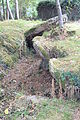
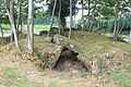
This building is classé au titre des monuments historiques de la France. It is indexed in the base Mérimée, a database of architectural heritage maintained by the French Ministry of Culture, under the reference PA00091069
|
| Object location | | View all coordinates using: OpenStreetMap |
|---|
 | |||||
| Upload media | |||||
| Instance of | |||||
|---|---|---|---|---|---|
| Location | Camors, Morbihan, Brittany, Q88521114, Metropolitan France, France | ||||
| Street address |
| ||||
| Heritage designation |
| ||||
 | |||||
Media in category "Allée couverte de Lann-et-Vein"
The following 6 files are in this category, out of 6 total.
-
 Allée couverte de Lann-et-Vein 8794.JPG 5,184 × 3,456; 6.73 MB
-
 Allée couverte de Lann-et-Vein 8796.JPG 3,456 × 5,184; 5.68 MB
-
 Allée couverte de Lann-et-Vein 8798.JPG 5,184 × 3,456; 6.52 MB
-
 Allée couverte de Lann-et-Vein 8799.JPG 5,184 × 3,456; 6.85 MB
-
 Allée couverte de Lann-et-Vein 8801.JPG 5,184 × 3,456; 6.63 MB
-
 Allée couverte de Lann-et-Vein 8809.JPG 5,184 × 3,456; 5.58 MB


