Category:Allée couverte de Loch-ar-Ronfl
Jump to navigation
Jump to search
| Object location | | View all coordinates using: OpenStreetMap |
|---|
|
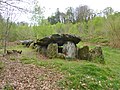
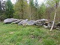
This building is classé au titre des monuments historiques de la France. It is indexed in the base Mérimée, a database of architectural heritage maintained by the French Ministry of Culture, under the reference PA00089972
|
gallery grave in Gouézec, France  | |||||
| Upload media | |||||
| Instance of | |||||
|---|---|---|---|---|---|
| Location | Gouézec, canton of Pleyben | ||||
| Heritage designation |
| ||||
 | |||||
Media in category "Allée couverte de Loch-ar-Ronfl"
The following 3 files are in this category, out of 3 total.
-
 479 Pont-Coblant.jpg 3,648 × 2,736; 5.44 MB
-
 480 Pont-Coblant.jpg 3,648 × 2,736; 5.09 MB
-
 Allée couverte de Loch-ar-Ronfl Gouézec.JPG 4,000 × 3,000; 3.9 MB

