Category:Allée couverte de Plouescat
Jump to navigation
Jump to search
|
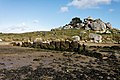
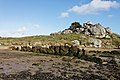
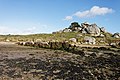
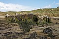
This building is classé au titre des monuments historiques de la France. It is indexed in the base Mérimée, a database of architectural heritage maintained by the French Ministry of Culture, under the reference PA00090215
|
| Object location | | View all coordinates using: OpenStreetMap |
|---|
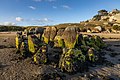
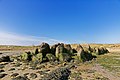
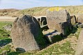
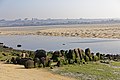
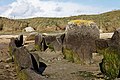
gallery grave in Plouescat, France  | |||||
| Upload media | |||||
| Instance of | |||||
|---|---|---|---|---|---|
| Location | Plouescat, Finistère, Brittany, Q88521114, Metropolitan France, France | ||||
| Heritage designation |
| ||||
 | |||||
Media in category "Allée couverte de Plouescat"
The following 51 files are in this category, out of 51 total.
-
 2022-07-19-Allée couverte de Plouescat-.jpg 6,753 × 4,487; 23.15 MB
-
 2022-07-19-Allée couverte de Plouescat-0697.jpg 6,378 × 4,252; 20.38 MB
-
 2022-07-19-Allée couverte de Plouescat-0700.jpg 6,578 × 4,385; 19.84 MB
-
 2022-07-19-Allée couverte de Plouescat-0702.jpg 6,530 × 4,353; 25.1 MB
-
 2022-07-19-Allée couverte de Plouescat-0704.jpg 6,216 × 4,144; 24.97 MB
-
 2022-07-19-Allée couverte de Plouescat-0705.jpg 5,751 × 3,834; 18.34 MB
-
 2022-07-19-Allée couverte de Plouescat-0710.jpg 6,565 × 4,377; 27.44 MB
-
 2022-07-19-Allée couverte de Plouescat-0713.jpg 6,720 × 4,480; 27.95 MB
-
 2022-07-19-Allée couverte de Plouescat-0719.jpg 6,720 × 4,480; 24.39 MB
-
 Bretagne - Finistère - Plouescat - 019.jpg 5,760 × 3,840; 26.57 MB
-
 Bretagne - Finistère - Plouescat - 020.jpg 5,760 × 3,840; 31.08 MB
-
 Bretagne - Finistère - Plouescat - 021.jpg 5,760 × 3,840; 31.86 MB
-
 Bretagne - Finistère - Plouescat - 022.jpg 5,760 × 3,840; 29.72 MB
-
 Bretagne - Finistère - Plouescat - 023.jpg 5,760 × 3,840; 30.7 MB
-
 Bretagne - Finistère - Plouescat - 024.jpg 5,760 × 3,840; 29.58 MB
-
 Bretagne - Finistère - Plouescat - 025.jpg 5,760 × 3,840; 30.13 MB
-
 Bretagne - Finistère - Plouescat - 026.jpg 5,760 × 3,840; 30.57 MB
-
 Bretagne - Finistère - Plouescat - 027.jpg 5,760 × 3,840; 32.66 MB
-
 Bretagne - Finistère - Plouescat - 028.jpg 5,760 × 3,840; 29.71 MB
-
 Bretagne - Finistère - Plouescat - 029.jpg 5,760 × 3,840; 28.9 MB
-
 Bretagne - Finistère - Plouescat - 030.jpg 5,760 × 3,840; 27.41 MB
-
 Bretagne - Finistère - Plouescat - 033.jpg 5,760 × 3,840; 27.13 MB
-
 Bretagne - Finistère - Plouescat - 034.jpg 5,760 × 3,840; 24.36 MB
-
 Plouescat (29) Allée couverte 01.JPG 1,588 × 1,191; 769 KB
-
 Plouescat (29) Allée couverte 02.JPG 1,588 × 1,191; 1.03 MB
-
 Plouescat (29) Allée couverte 03.JPG 1,588 × 1,191; 993 KB
-
 Plouescat (29) Allée couverte 04.JPG 1,588 × 1,191; 955 KB
-
 Plouescat (29) Allée couverte 05.JPG 1,588 × 1,191; 542 KB
-
 Plouescat - Allée couverte - Panneau.jpeg 4,128 × 2,322; 3.81 MB
-
 Plouescat - Allée couverte de Guinirvit - PA00090215 - 001.jpg 4,752 × 3,168; 23.61 MB
-
 Plouescat - Allée couverte de Guinirvit - PA00090215 - 002.jpg 4,688 × 3,123; 18.09 MB
-
 Plouescat - Allée couverte de Guinirvit - PA00090215 - 003.jpg 4,664 × 3,107; 17.65 MB
-
 Plouescat - Allée couverte de Guinirvit - PA00090215 - 004.jpg 4,636 × 3,089; 18.24 MB
-
 Plouescat - Allée couverte de Guinirvit - PA00090215 - 005.jpg 4,699 × 3,131; 19.06 MB
-
 Plouescat - Allée couverte de Guinirvit - PA00090215 - 006.jpg 4,688 × 3,123; 17.93 MB
-
 Plouescat - Allée couverte de Guinirvit - PA00090215 - 007.jpg 4,676 × 3,115; 18.08 MB
-
 Plouescat - Allée couverte de Guinirvit - PA00090215 - 008.jpg 4,688 × 3,123; 18.66 MB
-
 Plouescat - Allée couverte de Guinirvit - PA00090215 - 009.jpg 4,664 × 3,107; 18.11 MB
-
 Plouescat - Allée couverte de Guinirvit - PA00090215 - 010.jpg 4,752 × 3,168; 21.5 MB
-
 Plouescat - Allée couverte de Guinirvit - PA00090215 - 011.jpg 4,752 × 3,168; 21.39 MB
-
 Plouescat - Allée couverte de Guinirvit - PA00090215 - 012.jpg 4,752 × 3,168; 19.19 MB
-
 Plouescat - Allée couverte de Guinirvit - PA00090215 - 013.jpg 4,752 × 3,168; 22.13 MB
-
 Plouescat - Allée couverte de Guinirvit - PA00090215 - 014.jpg 4,636 × 3,089; 17.1 MB
-
 Plouescat - Allée couverte de Guinirvit - PA00090215 - 015.jpg 4,676 × 3,115; 18.79 MB
-
 Plouescat - Allée couverte de Guinirvit - PA00090215 - 016.jpg 4,538 × 3,023; 19.79 MB
-
 Plouescat - Allée couverte de Guinirvit - PA00090215 - 017.jpg 4,752 × 3,168; 22.31 MB
-
 Plouescat - Allée couverte de Guinirvit - PA00090215 - 018.jpg 4,752 × 3,168; 23.87 MB
-
 Plouescat - Allée couverte de Guinirvit - PA00090215 - 019.jpg 4,752 × 3,168; 24.83 MB
-
 Plouescat - L'allée couverte de Gunirvit 1.jpg 6,000 × 4,000; 15.4 MB
-
 Plouescat - L'allée couverte de Gunirvit 2.jpg 5,371 × 2,491; 6.94 MB
-
 Plouescat-21.jpg 4,896 × 3,672; 3.81 MB


_All%C3%A9e_couverte_01.JPG)
_All%C3%A9e_couverte_02.JPG)
_All%C3%A9e_couverte_03.JPG)
_All%C3%A9e_couverte_04.JPG)
_All%C3%A9e_couverte_05.JPG)


