Category:Amersham
Zur Navigation springen
Zur Suche springen
Deutsch: Amersham ist ein nordwestlich von London gelegener Ort in Buckinghamshire, England, und Verwaltungssitz des Distrikts Chiltern.
English: Amersham is a market town and civil parish within Chiltern district in Buckinghamshire, England, 27 miles north west of London, in the Chiltern Hills. It is part of the London commuter belt.
Italiano: Amersham è una cittadina di 17.719 abitanti della contea del Buckinghamshire, in Inghilterra.
Nederlands: Amersham is een plaats in het bestuurlijke gebied Chiltern, in het Engelse graafschap Buckinghamshire. De plaats telt 17.719 inwoners.
Norsk bokmål: Amersham er en by og et verdslig sogn i Chiltern distrikt i Buckinghamshire, England, 27 miles nordvest for London, i Chiltern Hills. Amersham tilhører Londons pendlerområde.
Polski: Amersham - miasto w Wielkiej Brytanii, w Anglii, w regionie South East England, w hrabstwie Buckinghamshire. W 2001 r. miasto zamieszkiwało 17 719 osób.
Română: Amersham este un oraş în comitatul Buckinghamshire, regiunea South East England, Anglia. Oraşul aparţine districtului Chiltern.
Gemeinde in der englischen Grafschaft Buckinghamshire  | |||||
| Medium hochladen | |||||
| Ist ein(e) | |||||
|---|---|---|---|---|---|
| Ort | Buckinghamshire, Südostengland, England | ||||
| Verschieden von | |||||
| Eventuell gleichwertig | Amersham (Wikimedia-Dublette, Civil Parish in England) | ||||
| offizielle Website | |||||
 | |||||
Unterkategorien
Es werden 15 von insgesamt 15 Unterkategorien in dieser Kategorie angezeigt:
In Klammern die Anzahl der enthaltenen Kategorien (K), Seiten (S), Dateien (D)
A
- Amersham Martyrs Memorial (7 D)
- Amersham War Memorial (9 D)
F
H
M
- Market Hall, Amersham (17 D)
P
- Amersham Prefab (11 D)
S
- Shardeloes Park (10 D)
T
- The Broadway, Amersham (15 D)
W
Medien in der Kategorie „Amersham“
Folgende 200 Dateien sind in dieser Kategorie, von 497 insgesamt.
(vorherige Seite) (nächste Seite)-
 A notice on the A413 - geograph.org.uk - 2806656.jpg 800 × 600; 103 KB
-
 A355 approaching Amersham - geograph.org.uk - 6131949.jpg 800 × 547; 104 KB
-
 A355 Gore Hill at Amersham boundary - geograph.org.uk - 4868968.jpg 640 × 480; 53 KB
-
 A355 on Gore Hill - geograph.org.uk - 5646217.jpg 640 × 428; 89 KB
-
 A404 - geograph.org.uk - 6421968.jpg 1.024 × 685; 144 KB
-
 A404 - geograph.org.uk - 6421984.jpg 1.024 × 684; 215 KB
-
 A404 - geograph.org.uk - 6425910.jpg 1.024 × 685; 205 KB
-
 A413 Amersham by-pass - geograph.org.uk - 2833861.jpg 640 × 481; 42 KB
-
 A413 Amersham Bypass - geograph.org.uk - 723096.jpg 640 × 480; 78 KB
-
 A413 Amersham Bypass - geograph.org.uk - 723109.jpg 640 × 480; 73 KB
-
 A413 Amersham bypass - geograph.org.uk - 966183.jpg 640 × 480; 69 KB
-
 A413 approaches roundabout south of Ostler's Wood - geograph.org.uk - 4107324.jpg 2.793 × 2.317; 1.005 KB
-

-
-
 A413 bridge over farm track - geograph.org.uk - 5000227.jpg 640 × 480; 180 KB
-
 A413 near Ash Grove - geograph.org.uk - 2834320.jpg 640 × 481; 38 KB
-
 A413 near Little Missenden - geograph.org.uk - 5673529.jpg 2.304 × 1.728; 865 KB
-
 A413 roundabout west of Amersham - geograph.org.uk - 2834289.jpg 640 × 481; 42 KB
-
 A413 south of Lott's Wood - geograph.org.uk - 4107329.jpg 3.427 × 2.451; 1,63 MB
-
 A413 west of Amersham - geograph.org.uk - 4176920.jpg 640 × 480; 93 KB
-
 A413, Amersham - geograph.org.uk - 6121471.jpg 800 × 600; 181 KB
-
 A413, Amersham bypass - geograph.org.uk - 1158169.jpg 640 × 480; 54 KB
-
 A413-A404 roundabout - geograph.org.uk - 2833874.jpg 640 × 480; 43 KB
-
 A4154 - geograph.org.uk - 6421897.jpg 1.024 × 684; 179 KB
-
 A416 - geograph.org.uk - 6421557.jpg 1.024 × 684; 279 KB
-
 A416 Station Road at Ruckles Way - geograph.org.uk - 4868971.jpg 640 × 479; 62 KB
-
 A416, Amersham - geograph.org.uk - 6121821.jpg 5.184 × 3.888; 4,65 MB
-
 A416, Chesham Rd - geograph.org.uk - 6421901.jpg 1.024 × 684; 206 KB
-
 Algae on the surface of Shardeloes Lake - geograph.org.uk - 3724506.jpg 4.608 × 3.456; 5,39 MB
-
-
 Amersham (5787390279).jpg 1.600 × 714; 218 KB
-
 Amersham (5787390509).jpg 1.600 × 1.067; 745 KB
-
 Amersham (5787390875).jpg 1.600 × 1.067; 436 KB
-
 Amersham (5787946534).jpg 1.600 × 1.067; 426 KB
-
 Amersham (5787947054).jpg 1.600 × 1.067; 474 KB
-
 Amersham (6147913974).jpg 1.600 × 1.067; 353 KB
-
 Amersham (6147914100).jpg 1.600 × 1.067; 422 KB
-
 Amersham - Tunnel exit 4 (4980688036).jpg 2.924 × 1.367; 1,68 MB
-
 Amersham Ambulance Station, Chiltern Avenue, Amersham, July 2022.jpg 4.032 × 3.024; 3,03 MB
-
 Amersham and Chesham from the air - geograph.org.uk - 4266860.jpg 640 × 480; 146 KB
-
 Amersham and Chesham from the air - geograph.org.uk - 4266909.jpg 640 × 480; 154 KB
-
 Amersham Auction Rooms - geograph.org.uk - 6132007.jpg 800 × 485; 95 KB
-
 Amersham Audi - geograph.org.uk - 6421991.jpg 1.024 × 685; 146 KB
-
 Amersham bus running day 2013 - geograph.org.uk - 3687570.jpg 4.320 × 2.432; 4,35 MB
-
 Amersham by-pass - geograph.org.uk - 2833887.jpg 640 × 481; 34 KB
-
 Amersham Chromotography skid 2 (15983503265).jpg 638 × 359; 53 KB
-
 Amersham Common - geograph.org.uk - 2795917.jpg 640 × 423; 254 KB
-
 Amersham Common Village Hall - geograph.org.uk - 6425907.jpg 1.024 × 684; 151 KB
-
 Amersham Cricket Club grounds - geograph.org.uk - 49794.jpg 640 × 480; 115 KB
-
 Amersham Fair 2004 - geograph.org.uk - 3105768.jpg 2.048 × 1.536; 1,33 MB
-
 Amersham Fair Organ Museum - geograph.org.uk - 5808480.jpg 3.840 × 2.160; 3,26 MB
-
 Amersham fire station - geograph.org.uk - 279999.jpg 640 × 427; 230 KB
-
 Amersham Fire Station, Bucks - geograph.org.uk - 2279030.jpg 3.072 × 2.304; 1,79 MB
-
 Amersham Free Church (1) - geograph.org.uk - 4103473.jpg 3.072 × 2.304; 1,79 MB
-
 Amersham Free Church (2) - geograph.org.uk - 4103479.jpg 3.072 × 2.304; 1,78 MB
-
 Amersham Free Church - geograph.org.uk - 2442872.jpg 640 × 480; 57 KB
-
 Amersham from the air - geograph.org.uk - 3321690.jpg 640 × 480; 142 KB
-
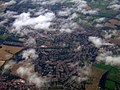 Amersham from the air - geograph.org.uk - 3321699.jpg 640 × 480; 144 KB
-
 Amersham from the air - geograph.org.uk - 4269511.jpg 480 × 640; 153 KB
-
 Amersham from the air - geograph.org.uk - 4269519.jpg 640 × 587; 186 KB
-
 Amersham health centre - geograph.org.uk - 965563.jpg 640 × 480; 73 KB
-

-
 Amersham Market folding sign 1 - geograph.org.uk - 3919830.jpg 1.024 × 768; 100 KB
-
 Amersham Market folding sign 2 - geograph.org.uk - 3919831.jpg 1.024 × 768; 59 KB
-
 Amersham Martyrs Memorial - geograph.org.uk - 6426050.jpg 960 × 1.280; 547 KB
-
 Amersham Martyrs Memorial from Field Path - geograph.org.uk - 6426042.jpg 1.024 × 768; 323 KB
-
 Amersham Old Town - The Eagle - geograph.org.uk - 5265574.jpg 2.560 × 1.920; 2,59 MB
-
 Amersham Old Town from Parsonage Wood - geograph.org.uk - 3724528.jpg 4.608 × 3.456; 5,73 MB
-
 Amersham Old Town from Parsonage Wood geograph-4267270-by-Peter-S.jpg 4.608 × 3.456; 4,68 MB
-

-

-
 Amersham Post Office - geograph.org.uk - 6421918.jpg 1.024 × 685; 126 KB
-
 Amersham School - geograph.org.uk - 5739713.jpg 1.956 × 1.404; 1,11 MB
-
 Amersham sorting office - geograph.org.uk - 2103437.jpg 3.504 × 2.336; 1,99 MB
-
 Amersham Station Car Park Sign - geograph.org.uk - 3916972.jpg 1.024 × 768; 65 KB
-
 Amersham Telephone Exchange - geograph.org.uk - 1045598.jpg 640 × 480; 87 KB
-
 Amersham Town Council, Flint Barn Court, Church Street, Amersham.jpg 4.580 × 3.435; 2,95 MB
-
 Amersham, A413 Shardeloes roundabout - geograph.org.uk - 1895652.jpg 640 × 480; 87 KB
-
 Amersham, Chestnut Lane - geograph.org.uk - 134256.jpg 640 × 480; 76 KB
-
 Amersham, Roundwood Road - geograph.org.uk - 131779.jpg 640 × 480; 80 KB
-
 Amersham, Stanley Hill Avenue - geograph.org.uk - 131792.jpg 640 × 467; 143 KB
-
 Amersham, Sun Houses One and Two - geograph.org.uk - 723146.jpg 640 × 480; 75 KB
-
 An Old Inn Amersham (NBY 443403).jpg 3.600 × 2.341; 2,08 MB
-
 Anti-HS2 hoarding in layby - geograph.org.uk - 3901940.jpg 4.320 × 3.240; 3,59 MB
-
 Arable land at Raans Farm - geograph.org.uk - 2795901.jpg 640 × 427; 173 KB
-
 Aston Martin Vantage V12 S 1.jpg 3.709 × 2.211; 2,03 MB
-
 Autumn colours at Weedonhill Wood - geograph.org.uk - 4267208.jpg 4.608 × 3.456; 6,78 MB
-
 Autumnal colours at Ladies’ Arbour - geograph.org.uk - 5621235.jpg 4.608 × 3.456; 6,87 MB
-
 B and M Motors - geograph.org.uk - 966186.jpg 640 × 480; 83 KB
-
 B4441 - geograph.org.uk - 6421908.jpg 1.024 × 684; 166 KB
-
 Bank of Reservoir - geograph.org.uk - 3437322.jpg 4.320 × 3.240; 2,87 MB
-
 Batchelors Way - geograph.org.uk - 6421945.jpg 1.024 × 684; 230 KB
-
 Batchelors Way - geograph.org.uk - 6421951.jpg 1.024 × 684; 218 KB
-
 Behind Amersham Station - geograph.org.uk - 6421939.jpg 1.024 × 684; 169 KB
-
 Bin day - geograph.org.uk - 2795925.jpg 640 × 427; 204 KB
-
 Bin day on Station Road - geograph.org.uk - 2795938.jpg 640 × 397; 221 KB
-
 Bird life at Shardeloes Lake - geograph.org.uk - 3905741.jpg 2.048 × 1.536; 334 KB
-
 Blackhorse Bridge - geograph.org.uk - 3916989.jpg 1.024 × 768; 117 KB
-
 Bluebells in Lane Wood - geograph.org.uk - 2004631.jpg 3.072 × 2.304; 1,26 MB
-
 Boot and Slipper roundabout - geograph.org.uk - 3917282.jpg 1.024 × 768; 125 KB
-
 Boot ^ Slipper - geograph.org.uk - 6421900.jpg 1.024 × 684; 132 KB
-
 Boot ^ Slipper sign - geograph.org.uk - 6421894.jpg 1.024 × 684; 152 KB
-
 Bottom House Farm Lane - geograph.org.uk - 5000184.jpg 640 × 480; 99 KB
-
 Bottom House Farm Lane - geograph.org.uk - 5000198.jpg 640 × 480; 164 KB
-
 Bottom House Farm Lane - geograph.org.uk - 5000212.jpg 640 × 480; 170 KB
-
 Branch sticking out of the water, Shardeloes Lake - geograph.org.uk - 3905739.jpg 2.048 × 1.536; 489 KB
-
 Bus on Hill Avenue, Amersham - geograph.org.uk - 5270428.jpg 1.024 × 768; 181 KB
-
 Bus stop on the A355, Gore Hill - geograph.org.uk - 6131945.jpg 800 × 600; 129 KB
-
 Canada geese at Shardeloes Lake - geograph.org.uk - 3724510.jpg 4.608 × 3.456; 4,78 MB
-
 Cemetery, Amersham - geograph.org.uk - 4176933.jpg 640 × 480; 131 KB
-
 Cherry Lane - geograph.org.uk - 5479045.jpg 640 × 480; 136 KB
-
 Chesham Rd, A416 - geograph.org.uk - 6421904.jpg 1.024 × 685; 179 KB
-
 Chesham Rd, A416 - geograph.org.uk - 6421907.jpg 1.024 × 684; 219 KB
-
 Chesham Road at the junction of Rickmansworth Road - geograph.org.uk - 4484708.jpg 2.434 × 1.738; 1,05 MB
-
 Chesham Road, Amersham - geograph.org.uk - 2216981.jpg 4.320 × 3.240; 4,6 MB
-
 Chestnut Lane, Amersham - geograph.org.uk - 2442879.jpg 640 × 480; 114 KB
-
 Children’s playground, Amersham - geograph.org.uk - 5996496.jpg 4.608 × 3.456; 4,77 MB
-
 Chiltern Avenue - geograph.org.uk - 965567.jpg 640 × 480; 84 KB
-
 Chiltern hills near to Amersham Old Town - geograph.org.uk - 4267253.jpg 4.608 × 3.456; 5,34 MB
-
 Chiltern Pools - geograph.org.uk - 1054102.jpg 640 × 480; 51 KB
-
 Chilterns Crematorium, Amersham - geograph.org.uk - 103303.jpg 640 × 480; 93 KB
-
 Christmas Greetings (NBY 443028).jpg 3.600 × 2.337; 1,95 MB
-
 Coleshill Cricket Club - geograph.org.uk - 769658.jpg 640 × 480; 67 KB
-
 Coleshill Water Tower - geograph.org.uk - 5154115.jpg 5.202 × 3.465; 1,84 MB
-
 Convenience stores, Amersham - geograph.org.uk - 988613.jpg 640 × 390; 66 KB
-
 Copperkins Lane by Heatherton House School - geograph.org.uk - 4483146.jpg 2.516 × 1.860; 2,02 MB
-
 Copperkins Lane, Amersham - geograph.org.uk - 6132017.jpg 800 × 600; 119 KB
-
 Copperkins Lane, Chesham Bois - geograph.org.uk - 4483170.jpg 1.920 × 2.560; 2,02 MB
-
 Copperkins Lane, Hyde Heath - geograph.org.uk - 4483211.jpg 2.560 × 1.920; 1,88 MB
-
 Copperkins Lane, Hyde Heath - geograph.org.uk - 4483213.jpg 2.560 × 1.920; 1,92 MB
-
 Cottages at Bury End - geograph.org.uk - 5154118.jpg 5.184 × 3.456; 4,68 MB
-
 Crop field, Gore Hill - geograph.org.uk - 6121469.jpg 800 × 600; 141 KB
-
 David's Woods - geograph.org.uk - 1065062.jpg 640 × 480; 76 KB
-
 Decimal Place Amersham - geograph.org.uk - 3917285.jpg 1.024 × 768; 175 KB
-
 Devonshire Avenue, Amersham - geograph.org.uk - 6121485.jpg 800 × 600; 161 KB
-
 Disused bird hide - geograph.org.uk - 1296895.jpg 640 × 480; 133 KB
-
 Disused farm buildings off Cherry Lane - geograph.org.uk - 5479043.jpg 640 × 480; 153 KB
-
 Domesday Plaque on Amersham Market Hall - geograph.org.uk - 6425999.jpg 1.024 × 512; 146 KB
-

-
 Double Mini Roundabout Sign - Rickmansworth Road - geograph.org.uk - 3919262.jpg 1.024 × 768; 200 KB
-
 Dr Challoners Grammar School.jpg 850 × 577; 612 KB
-
 Drake Almshouses in Old Amersham - geograph.org.uk - 5484848.jpg 2.592 × 1.944; 1,39 MB
-
 Drive up to Woodrow High House - geograph.org.uk - 1052073.jpg 640 × 480; 76 KB
-
 Entering Amersham - geograph.org.uk - 6421554.jpg 1.024 × 684; 257 KB
-

-
 Exit to School Lane from Shardloes roundabout - geograph.org.uk - 2633043.jpg 2.560 × 1.920; 1 MB
-
 Farmland above Amersham old town - geograph.org.uk - 2795974.jpg 640 × 427; 205 KB
-
 Farmland and houses, Amersham - geograph.org.uk - 1589871.jpg 640 × 480; 158 KB
-
 Farmland, Amersham - geograph.org.uk - 2819741.jpg 640 × 480; 151 KB
-
 Farmland, Amersham - geograph.org.uk - 2819748.jpg 640 × 480; 141 KB
-
 Farmland, Amersham - geograph.org.uk - 2819767.jpg 640 × 480; 185 KB
-
 Field and footpath east of Finch Lane - geograph.org.uk - 4013380.jpg 640 × 480; 110 KB
-
 Field by the A413, Weedon Hill - geograph.org.uk - 5742576.jpg 2.304 × 1.728; 812 KB
-
 Field by the A413, Weedon Hill - geograph.org.uk - 5742579.jpg 2.304 × 1.728; 1,65 MB
-
 Field off Stanley Hill - geograph.org.uk - 1052080.jpg 640 × 480; 122 KB
-
 Fields by Latimer Road - geograph.org.uk - 2369868.jpg 1.600 × 1.200; 534 KB
-
 Fields by Latimer Road - geograph.org.uk - 2369871.jpg 1.600 × 1.200; 538 KB
-
 Fields by the A404, Amersham - geograph.org.uk - 4700372.jpg 2.560 × 1.920; 1,13 MB
-
 Flats, Amersham - geograph.org.uk - 6410559.jpg 1.024 × 685; 134 KB
-
 Flowers in the Memorial Gardens - geograph.org.uk - 3656052.jpg 1.600 × 1.262; 570 KB
-
 Foot crossing over railway - geograph.org.uk - 3129782.jpg 4.000 × 3.000; 2,64 MB
-
 Footbridge over River Misbourne - geograph.org.uk - 2612056.jpg 4.000 × 3.000; 2,25 MB
-

-
 Footpath along the Misbourne valley - geograph.org.uk - 2796020.jpg 640 × 429; 213 KB
-
 Footpath along the Misbourne valley - geograph.org.uk - 2796036.jpg 640 × 427; 204 KB
-
 Footpath along the Misbourne valley - geograph.org.uk - 3437336.jpg 4.320 × 3.240; 2,88 MB
-
 Footpath by Forest Cottages - geograph.org.uk - 1054056.jpg 640 × 480; 121 KB
-
 Footpath Divides entering Lane Wood - geograph.org.uk - 6426055.jpg 1.024 × 768; 315 KB
-
 Footpath from Amersham towards Chalfont St Giles - geograph.org.uk - 3437354.jpg 4.320 × 3.240; 3,46 MB
-
 Footpath in the Misbourne valley - geograph.org.uk - 2796049.jpg 640 × 427; 199 KB
-
 Footpath near Days Wood - geograph.org.uk - 2415287.jpg 1.024 × 683; 491 KB
-
 Footpath near Shardeloes House - geograph.org.uk - 2515015.jpg 4.000 × 3.000; 2,15 MB
-
 Footpath off White Lion Rd - geograph.org.uk - 6425925.jpg 1.024 × 684; 349 KB
-
 Footpath past Raans Farm - geograph.org.uk - 2795905.jpg 640 × 447; 224 KB
-
 Footpath through barley near Amersham - geograph.org.uk - 1589862.jpg 640 × 480; 162 KB
-
 Footpath through rape near Amersham - geograph.org.uk - 1589867.jpg 640 × 480; 160 KB
-
 Footpath through wheat near Amersham - geograph.org.uk - 1589802.jpg 640 × 480; 153 KB
-
 Footpath to Coleshill - geograph.org.uk - 2612079.jpg 4.000 × 3.000; 2,42 MB
-
 Footpath to Raans Farm - geograph.org.uk - 1052096.jpg 640 × 480; 80 KB
-
 Footpath to Rogers Wood - geograph.org.uk - 2514925.jpg 4.000 × 3.000; 2,34 MB
-
 Footpath to Weedonhill Wood - geograph.org.uk - 1054186.jpg 640 × 480; 84 KB
-
 Footpath to Weedonhill Wood - geograph.org.uk - 2515020.jpg 4.000 × 3.000; 2,48 MB
-
 Footpath towards A413 - geograph.org.uk - 2796014.jpg 640 × 440; 253 KB
-
 Footpath towards Amersham - geograph.org.uk - 5154109.jpg 5.202 × 3.465; 3,65 MB
-
 Former Guido's Italian Restaurant, Amersham (1) - geograph.org.uk - 5425407.jpg 2.592 × 1.944; 1,42 MB
-
 Former Guido's Italian Restaurant, Amersham (2) - geograph.org.uk - 5425425.jpg 2.592 × 1.944; 1,38 MB
-
 Former Merritts Peugeot dealer, Amersham - geograph.org.uk - 2217019.jpg 4.320 × 3.240; 3,74 MB
-
 Game of cricket, Amersham - geograph.org.uk - 3724520.jpg 4.608 × 3.456; 5,41 MB
-
 Garden of Remembrance - geograph.org.uk - 2254817.jpg 640 × 480; 110 KB
-
 Garden of Remembrance, Old Amersham - geograph.org.uk - 6131989.jpg 800 × 600; 201 KB
-
 GE Healthcare Amersham radiopharmaceuticals packaging.jpg 4.174 × 2.777; 4,85 MB
-
 George V postbox on the A416, Amersham - geograph.org.uk - 6121817.jpg 2.488 × 4.316; 2,11 MB
-
 George V postbox, Amersham Railway Station - geograph.org.uk - 6121823.jpg 2.726 × 5.127; 3,1 MB
-
 Glenwood - geograph.org.uk - 6421986.jpg 1.024 × 748; 122 KB
-
 Glimpse of Amersham Old Town from Platts Lane - geograph.org.uk - 5996491.jpg 4.608 × 3.456; 4,82 MB
-

-

-

-
 Green Lane, Amersham - geograph.org.uk - 5907633.jpg 1.600 × 1.018; 381 KB
-
 Green, The Drive - geograph.org.uk - 6421941.jpg 1.024 × 684; 205 KB


.jpg)
.jpg)
.jpg)
.jpg)
.jpg)
.jpg)
.jpg)
.jpg)


.jpg)


_-_geograph.org.uk_-_4103473.jpg)
_-_geograph.org.uk_-_4103479.jpg)


_-_geograph.org.uk_-_722221.jpg)


.jpg)


.jpg)


_-_geograph.org.uk_-_5425407.jpg)
_-_geograph.org.uk_-_5425425.jpg)


