Category:Anakie Siding, Queensland
Jump to navigation
Jump to search
rural locality in Queensland, Australia  Вид города (2013) | |||||
| Upload media | |||||
| Instance of | |||||
|---|---|---|---|---|---|
| Location |
| ||||
| Different from | |||||
 | |||||
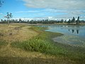
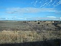
English: Anakie Siding is a rural locality in Queensland, Australia. The town is located just to the south of the Capricorn Highway, 44 km west of Emerald, and is situated in a region called the Gemfields where sapphires are mined. (→Anakie, Queensland)
Русский: Анаки . Ближайший крупный город — Рокгемптон (расположен в 290 километрах на востоке). (→Анаки)
Media in category "Anakie Siding, Queensland"
The following 16 files are in this category, out of 16 total.
-
 Anakie Billabong - panoramio (1).jpg 4,608 × 3,456; 3.43 MB
-
 Anakie Billabong - panoramio (2).jpg 4,608 × 3,456; 3.45 MB
-
 Anakie Billabong - panoramio (3).jpg 4,608 × 3,456; 3.44 MB
-
 Anakie Billabong - panoramio.jpg 4,608 × 3,456; 3.22 MB
-
 Brolgas Dancing - panoramio.jpg 4,608 × 3,456; 3.37 MB
-
 Dead Tree - panoramio (5).jpg 4,608 × 3,456; 3.41 MB
-
 Flock of Birds - panoramio.jpg 4,608 × 3,456; 3.31 MB
-
 Greener Pastures - panoramio (1).jpg 4,608 × 3,456; 3.48 MB
-
 Greener Pastures - panoramio (2).jpg 4,608 × 3,456; 3.24 MB
-
 Greener Pastures - panoramio (3).jpg 4,608 × 3,456; 3.42 MB
-
 Greener Pastures - panoramio (4).jpg 4,608 × 3,456; 3.18 MB
-
 Greener Pastures - panoramio.jpg 4,608 × 3,456; 3.45 MB
-
 Outskirts of Anakie - panoramio.jpg 4,608 × 3,456; 3.37 MB
-
 Sweeping Grazing Land - panoramio.jpg 4,608 × 3,456; 3.4 MB
-
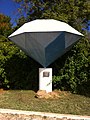 The Big Sapphire.jpg 1,936 × 2,592; 2.15 MB
-
 Water Tower in Anakie - panoramio.jpg 4,608 × 3,456; 3.19 MB
.jpg)
.jpg)
.jpg)


.jpg)

.jpg)
.jpg)
.jpg)
.jpg)


