Category:Andreanof Islands
Jump to navigation
Jump to search
group of islands in the Aleutian Islands  Мапа Андреянівських островів  | |||||
| Upload media | |||||
| Instance of |
| ||||
|---|---|---|---|---|---|
| Part of | |||||
| Location | Alaska | ||||
| Located in or next to body of water | |||||
| Capital | |||||
| Length |
| ||||
| Highest point |
| ||||
| Area |
| ||||
| Elevation above sea level |
| ||||
 | |||||
Subcategories
This category has the following 8 subcategories, out of 8 total.
Media in category "Andreanof Islands"
The following 6 files are in this category, out of 6 total.
-
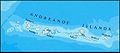 Andreanof Map.jpg 560 × 249; 24 KB
-
 2008-06-10-CPX-0715a.jpg 800 × 500; 125 KB
-
 Amatignak coast.jpg 800 × 500; 112 KB
-
 Igitkin Island.jpg 4,288 × 2,848; 5.98 MB
-
 Kasatochi Island bluffs, Andreanof Islands - DPLA - 5bcddb5aeaa8f1315edbce212d84d5a1.jpg 3,000 × 2,000; 886 KB
-
 Kasatochi Island USFWS.jpg 400 × 266; 34 KB


