Category:Arnprior, Stirling
Jump to navigation
Jump to search
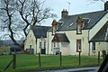
English: Arnprior is a village in the the Stirling council area of Scotland. It is located on the A811 about 12 miles west of Stirling and is one of the smallest community council areas in Stirlingshire with a population of about 200.
Gàidhlig: 'S e baile ann an Comhairle Shruighlea a tha ann an Arnprior. Tha am baile suidhichte air an A811 mu 12 mìltean air àird an iar Ghlaschu. 'S e seo na co-chomharran aige: 56° 6′ 36″ Tuath agus 4° 13′ 48″ Iar.
village in Stirling, Scotland, UK  | |||||
| Upload media | |||||
| Instance of | |||||
|---|---|---|---|---|---|
| Location |
| ||||
 | |||||
Media in category "Arnprior, Stirling"
The following 4 files are in this category, out of 4 total.
-
 Arnprior - geograph.org.uk - 201931.jpg 640 × 480; 266 KB
-
 Causewayhead Farm Kippen - geograph.org.uk - 718201.jpg 640 × 427; 78 KB
-
 Pheasant at Causewayhead Farm Kippen - geograph.org.uk - 718210.jpg 640 × 427; 89 KB
-
 Road to Causewayhead Farm - geograph.org.uk - 718205.jpg 640 × 427; 104 KB


