Category:Assenstraat 4, Deventer
Jump to navigation
Jump to search
| Object location | | View all coordinates using: OpenStreetMap |
|---|
 | |||||
| Upload media | |||||
| Instance of |
| ||||
|---|---|---|---|---|---|
| Location | Deventer, Overijssel, Netherlands | ||||
| Street address |
| ||||
| Located on street | |||||
| Heritage designation |
| ||||
 | |||||
|
This is a category about rijksmonument number 12398
|
| Address |
|
Media in category "Assenstraat 4, Deventer"
The following 19 files are in this category, out of 19 total.
-
 Achtergevels - Deventer - 20055212 - RCE.jpg 1,200 × 1,200; 288 KB
-
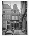
 Assenstraat 4 Deventer.jpg 1,712 × 2,560; 1.15 MB
-
 Bursesteeg 7, overzicht achtergevels - Deventer - 20055213 - RCE.jpg 1,197 × 1,200; 260 KB
-
 Deventer, Vleeshouwerstraat, view to house 4 Assenstraat.jpg 1,701 × 2,551; 753 KB
-
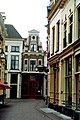
 Exterieur VOORGEVEL - Deventer - 20261310 - RCE.jpg 797 × 1,200; 162 KB
-
 M 14 - Deventer - 20055205 - RCE.jpg 1,192 × 1,200; 251 KB
-
 Overzicht - Deventer - 20403283 - RCE.jpg 804 × 1,200; 186 KB
-
 Overzicht van zijgevel en achtergevels na brand - Deventer - 20334553 - RCE.jpg 1,200 × 800; 230 KB
-
 Overzicht voorgevel in de steigers, na brand - Deventer - 20334546 - RCE.jpg 800 × 1,200; 158 KB
-
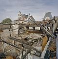 Restanten na brand - Deventer - 20334554 - RCE.jpg 1,188 × 1,200; 321 KB
-
 Restanten na brand - Deventer - 20334555 - RCE.jpg 1,189 × 1,200; 351 KB
-
 Restanten na brand - Deventer - 20334556 - RCE.jpg 1,192 × 1,200; 282 KB
-
 Restanten na brand - Deventer - 20334557 - RCE.jpg 1,193 × 1,200; 350 KB
-

-

-

-

-
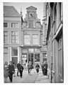 Voorgevel - Deventer - 20055207 - RCE.jpg 958 × 1,200; 133 KB
-
 Voorgevel - Deventer - 20055208 - RCE.jpg 958 × 1,200; 136 KB


