Category:Assenstraat 6A, Deventer
Jump to navigation
Jump to search
| Object location | | View all coordinates using: OpenStreetMap |
|---|
 | |||||
| Upload media | |||||
| Instance of | |||||
|---|---|---|---|---|---|
| Location | Deventer, Overijssel, Netherlands | ||||
| Street address |
| ||||
| Located on street | |||||
| Heritage designation |
| ||||
 | |||||
|
This is a category about rijksmonument number 12400
|
| Address |
|
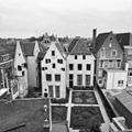
Media in category "Assenstraat 6A, Deventer"
The following 7 files are in this category, out of 7 total.
-
 Achtergevels - Deventer - 20055212 - RCE.jpg 1,200 × 1,200; 288 KB
-
 Assenstraat 6A Deventer.jpg 1,712 × 2,560; 849 KB
-
 Bursesteeg 7, overzicht achtergevels - Deventer - 20055213 - RCE.jpg 1,197 × 1,200; 260 KB
-
 Exterieur OVAAL (VOORBEELD VAN ZO GENAAMDE DUIVENSCHRIK) - Deventer - 20277136 - RCE.jpg 1,200 × 1,195; 243 KB
-
 M 14 - Deventer - 20055205 - RCE.jpg 1,192 × 1,200; 251 KB
-
 Overzicht - Deventer - 20403283 - RCE.jpg 804 × 1,200; 186 KB
-
 Poort - Deventer - 20055211 - RCE.jpg 805 × 1,200; 207 KB


_-_Deventer_-_20277136_-_RCE.jpg)


