Category:Astley and Dunley
Zur Navigation springen
Zur Suche springen
English: Astley and Dunley is a civil parish in the Malvern Hills district, in the county of Worcestershire, England.
civil parish in Malvern Hills, Worcestershire, England | |||||
| Medium hochladen | |||||
| Ist ein(e) | |||||
|---|---|---|---|---|---|
| Ort | Malvern Hills, Worcestershire, West Midlands, England | ||||
 | |||||
Unterkategorien
Es werden 5 von insgesamt 5 Unterkategorien in dieser Kategorie angezeigt:
In Klammern die Anzahl der enthaltenen Kategorien (K), Seiten (S), Dateien (D)
Medien in der Kategorie „Astley and Dunley“
Folgende 180 Dateien sind in dieser Kategorie, von 180 insgesamt.
-
 'Wandering Leo III' on the River Severn - geograph.org.uk - 3751953.jpg 1.600 × 1.195; 638 KB
-
 A clearing in Astley Woods - geograph.org.uk - 4289856.jpg 640 × 480; 85 KB
-
 A maize crop - geograph.org.uk - 5417694.jpg 1.024 × 768; 313 KB
-
 A451 at Lower Strand Cottages - geograph.org.uk - 4408310.jpg 1.600 × 1.094; 530 KB
-
 A451 at Yarhampton Cross - geograph.org.uk - 4406949.jpg 1.600 × 1.156; 418 KB
-
 A451 heading towards Dunley - geograph.org.uk - 4408286.jpg 1.600 × 1.094; 489 KB
-
 A451 in the village of Dunley - geograph.org.uk - 4408320.jpg 1.600 × 1.087; 637 KB
-
 Anglers and weir near Lincomb, Worcestershire - geograph.org.uk - 3779134.jpg 1.024 × 768; 424 KB
-
 Anglers at Larford Lakes, Larford, Worcs - geograph.org.uk - 4326975.jpg 1.024 × 681; 177 KB
-

-
 Astley church - geograph.org.uk - 5967997.jpg 1.024 × 768; 229 KB
-
 Astley Hall - geograph.org.uk - 5968009.jpg 1.024 × 768; 229 KB
-
 Back garden pontoon made of oil drums - geograph.org.uk - 3158532.jpg 1.024 × 768; 109 KB
-
 Boat crane at Stourport Marina - geograph.org.uk - 3159408.jpg 1.024 × 768; 114 KB
-
 Boat moored on the east bank of the Severn - geograph.org.uk - 3159359.jpg 1.024 × 768; 146 KB
-
 Boats moored by Redstone Rock - geograph.org.uk - 5693599.jpg 5.760 × 3.840; 7,38 MB
-
 Boom across the River Severn - geograph.org.uk - 3753002.jpg 1.600 × 1.157; 527 KB
-

-

-

-

-

-
 Bridge over the Dick Brook, Astley, Worcs - geograph.org.uk - 3872337.jpg 1.024 × 670; 301 KB
-
 Bridle path emerges from Lower Astley Wood - geograph.org.uk - 4941217.jpg 1.600 × 1.200; 834 KB
-
 Bridle path through Lower Astley Wood - geograph.org.uk - 4941204.jpg 1.600 × 1.200; 781 KB
-
 Bridle path to Shrawley Woods from The Burf - geograph.org.uk - 4941197.jpg 1.600 × 1.200; 749 KB
-
 Broadsands along the A451 - geograph.org.uk - 4408299.jpg 1.600 × 1.013; 556 KB
-
 Brunthorne Lane looking north, near Areley Kings - geograph.org.uk - 2577304.jpg 1.024 × 768; 218 KB
-
 Brunthorne Lane looking south, near Areley Kings - geograph.org.uk - 2577319.jpg 778 × 1.024; 287 KB
-

-
 Caravans north of Hampstall Inn - geograph.org.uk - 3158540.jpg 1.024 × 768; 160 KB
-

-

-

-
 Church at Astley - geograph.org.uk - 4289495.jpg 640 × 480; 75 KB
-
 Church Lane near Astley, Worcs - geograph.org.uk - 3852023.jpg 1.024 × 681; 301 KB
-
 Church Lane, Astley, Worcs - geograph.org.uk - 3856685.jpg 1.024 × 665; 261 KB
-
 Classic Norman work, St Peter, Astley - geograph.org.uk - 4742455.jpg 2.928 × 1.700; 2,35 MB
-
 Concrete Slab Works at Larford - geograph.org.uk - 5697780.jpg 1.280 × 720; 536 KB
-
 Cormorant in a tree along the River Severn - geograph.org.uk - 3751948.jpg 1.600 × 1.470; 394 KB
-
 Dick Brook Bridge - geograph.org.uk - 4408262.jpg 1.600 × 1.146; 841 KB
-
 Don't post your letters here^ - geograph.org.uk - 3877672.jpg 652 × 1.024; 181 KB
-
 Dunley Road towards Areley Kings - geograph.org.uk - 4408457.jpg 1.600 × 1.189; 474 KB
-
 Edge of Lower Astley Wood - geograph.org.uk - 4941330.jpg 1.600 × 1.200; 595 KB
-
 End of access road, Astley, Worcs - geograph.org.uk - 3857823.jpg 1.024 × 664; 224 KB
-

-
 Entry into Astley Vineyards, Hampstall Lane - geograph.org.uk - 4941351.jpg 1.600 × 1.200; 652 KB
-
 Farmland in the village of Dunley - geograph.org.uk - 4408347.jpg 1.600 × 1.244; 412 KB
-
 Fields south of Astley Cross, Stourport - geograph.org.uk - 5165747.jpg 800 × 549; 128 KB
-
 Flooded Lower Astley Wood - geograph.org.uk - 4941212.jpg 1.600 × 1.200; 826 KB
-
 Footbridge along the Severn Way Footpath - geograph.org.uk - 3756411.jpg 1.600 × 1.160; 667 KB
-
 Footbridge into Shrawley Wood - geograph.org.uk - 4941345.jpg 1.600 × 1.200; 813 KB
-

-
 Footpath and farmland near the Dick Brook - geograph.org.uk - 4408269.jpg 1.600 × 1.200; 722 KB
-
 Footpath near Astley - geograph.org.uk - 5690562.jpg 1.280 × 800; 703 KB
-
 Footpaths diverge - geograph.org.uk - 4941339.jpg 1.600 × 1.200; 818 KB
-
 Gabions on Jennings Wood Lane - geograph.org.uk - 2551090.jpg 2.048 × 1.536; 2,5 MB
-
 Glasshampton Roofline - geograph.org.uk - 1504525.jpg 640 × 480; 156 KB
-

-
 Houses along the A451 in Dunley - geograph.org.uk - 4408331.jpg 1.600 × 1.127; 601 KB
-

-
 Houses with moorings off Hampstall Lane - geograph.org.uk - 3158524.jpg 1.024 × 768; 120 KB
-
 Isolated home on the River Severn - geograph.org.uk - 4941200.jpg 1.600 × 1.200; 553 KB
-
 Junction For Larford - geograph.org.uk - 1400721.jpg 640 × 480; 198 KB
-
 Landing stage along the River Severn - geograph.org.uk - 3751943.jpg 1.600 × 1.200; 542 KB
-
 Lane To Astley - geograph.org.uk - 1400521.jpg 480 × 640; 142 KB
-
 Lane to Astley Public Loading Wharf - geograph.org.uk - 4941189.jpg 1.600 × 1.200; 693 KB
-
 Lane To Dunley - geograph.org.uk - 1400532.jpg 640 × 480; 182 KB
-
 Lane To The Burf - geograph.org.uk - 1400536.jpg 640 × 480; 189 KB
-

-
 Larford Lakes, Larford, Worcs - geograph.org.uk - 4326948.jpg 1.024 × 681; 158 KB
-
 Larford Lakes, Larford, Worcs - geograph.org.uk - 4326959.jpg 1.024 × 662; 157 KB
-
 Larford Lane, Larford, Worcs - geograph.org.uk - 4325535.jpg 1.024 × 673; 196 KB
-
 Larford Lane, near Lincomb, Worcs - geograph.org.uk - 6247308.jpg 1.024 × 672; 233 KB
-
 Larford Lane, near Lincomb, Worcs - geograph.org.uk - 6247324.jpg 1.024 × 681; 170 KB
-
 Looking southwest from the B4196 in 1987 - geograph.org.uk - 2985284.jpg 923 × 669; 143 KB
-
 Looking towards Church Lane, Astley, Worcs - geograph.org.uk - 3856682.jpg 1.024 × 656; 287 KB
-

-

-
-
 Metal platform along the Severn Way Footpath - geograph.org.uk - 3756428.jpg 1.600 × 1.258; 967 KB
-

-

-
 Moored boats south of Stourport, Worcestershire - geograph.org.uk - 3808733.jpg 1.024 × 1.024; 554 KB
-
 Moored boats south-east of Stourport, Worcestershire - geograph.org.uk - 3786865.jpg 1.024 × 1.024; 470 KB
-

-
 Moorings on the east bank of the Severn - geograph.org.uk - 3159402.jpg 1.024 × 768; 140 KB
-
 Narrow boats moored along the River Severn - geograph.org.uk - 3756406.jpg 1.600 × 1.166; 397 KB
-
 Narrowboat on the River Severn - geograph.org.uk - 3752902.jpg 1.600 × 1.078; 671 KB
-
 Nutnell Pool, near Noutard's Green, Worcestershire - geograph.org.uk - 6202972.jpg 5.184 × 3.888; 3,73 MB
-
 Overgrown west bank of the Severn - geograph.org.uk - 3159367.jpg 1.024 × 768; 135 KB
-
 Pontoon of oil drums, east bank of the Severn - geograph.org.uk - 3159334.jpg 1.024 × 768; 156 KB
-
 Poplars - geograph.org.uk - 4174109.jpg 891 × 1.024; 520 KB
-
 Poppies in a field headland - geograph.org.uk - 5417466.jpg 1.024 × 768; 337 KB
-

-

-

-

-
 Public footpath at Astley, Worcs - geograph.org.uk - 3872318.jpg 1.024 × 675; 343 KB
-

-

-

-
 Pylons Heading West - geograph.org.uk - 1400550.jpg 640 × 480; 188 KB
-
 Redhouse Lane junction in Dunley - geograph.org.uk - 4408399.jpg 1.600 × 1.090; 576 KB
-
 Redstone Rock and the River Severn - geograph.org.uk - 3756435.jpg 1.329 × 1.600; 712 KB
-

-
 Remains of Astley Forge Mill - geograph.org.uk - 4289866.jpg 640 × 480; 160 KB
-

-
 River Severn looking south above Lincombe Lock - geograph.org.uk - 2049193.jpg 3.072 × 2.304; 3,09 MB
-
-
 River Severn near Lower Astley Wood - geograph.org.uk - 2868714.jpg 1.024 × 680; 151 KB
-
 River Severn near Stourport-on-Severn - geograph.org.uk - 2869485.jpg 1.024 × 680; 123 KB
-

-
 Riverside at The Burf, Worcestershire - geograph.org.uk - 3766161.jpg 1.024 × 1.024; 647 KB
-

-
 Riverside homes at The Burf, Worcestershire - geograph.org.uk - 3765730.jpg 1.280 × 753; 500 KB
-
 Road junction on the B4196 at Astley, Worcs - geograph.org.uk - 3435090.jpg 1.024 × 717; 227 KB
-
-
 Rolling Countryside Near Yarhampton - geograph.org.uk - 1400500.jpg 640 × 480; 226 KB
-

-

-
 Severn Way Footpath near Stourport Marina - geograph.org.uk - 3753004.jpg 1.600 × 1.200; 761 KB
-
 Sir Thomas Winford, died 1702, St Peter, Astley - geograph.org.uk - 4745514.jpg 1.915 × 3.195; 1,59 MB
-
 St Peter Astley - geograph.org.uk - 4741915.jpg 2.000 × 3.008; 3,71 MB
-
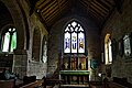
 St Peter, Astley - geograph.org.uk - 4740355.jpg 2.917 × 1.939; 2,02 MB
-
 St Peter, Astley - geograph.org.uk - 4740438.jpg 4.758 × 3.665; 6,49 MB
-
 St Peter, Astley - geograph.org.uk - 4741916.jpg 3.008 × 2.000; 4,64 MB
-
 St Peter, Astley - geograph.org.uk - 4741918.jpg 2.364 × 1.973; 1,51 MB
-
 St Peter, Astley - geograph.org.uk - 4742589.jpg 2.802 × 1.844; 1,51 MB
-
 St Peter, Astley - geograph.org.uk - 4742606.jpg 2.982 × 1.982; 2,7 MB
-
 St Peter, Astley - geograph.org.uk - 4742664.jpg 2.000 × 3.008; 3,67 MB
-
 St Peter, Astley - geograph.org.uk - 4742676.jpg 1.960 × 2.947; 3,28 MB
-
 St Peter, Astley - geograph.org.uk - 4745997.jpg 2.955 × 1.964; 1,65 MB
-
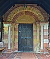 St Peter, Astley - the Norman south doorway - geograph.org.uk - 4742548.jpg 2.046 × 2.415; 1,72 MB
-
 St Peters Church, Astley, in its setting - geograph.org.uk - 5976846.jpg 1.280 × 640; 572 KB
-
 St. Peter, Astley - geograph.org.uk - 4763723.jpg 3.119 × 2.083; 1,44 MB
-
 St. Peter, Astley - geograph.org.uk - 4763736.jpg 3.227 × 2.043; 1,87 MB
-

-

-

-

-

-

-
 Syntley Farm, Astley - geograph.org.uk - 5714578.jpg 1.280 × 720; 428 KB
-
 Syntley Farm, Astley, in 1968 - geograph.org.uk - 5714554.jpg 1.280 × 720; 500 KB
-
 The A451 near Dick Brook Bridge - geograph.org.uk - 4408275.jpg 1.600 × 1.200; 760 KB
-
 The B4196 road, near The Burf, Worcs - geograph.org.uk - 4575001.jpg 1.024 × 768; 260 KB
-
 The Burf - Housing Around A Green - geograph.org.uk - 1400549.jpg 640 × 480; 168 KB
-

-
 The Burf - Village Lane - geograph.org.uk - 1400544.jpg 640 × 480; 196 KB
-
 The Dog Inn, Dunley - geograph.org.uk - 4408364.jpg 1.600 × 1.076; 378 KB
-
 The Hampstall Inn - geograph.org.uk - 5695683.jpg 5.358 × 3.572; 7,22 MB
-
 The Hampstall Inn and its landing stage - geograph.org.uk - 3158535.jpg 1.024 × 768; 105 KB
-
 The Hampstall Inn, Astley Burf - geograph.org.uk - 4533473.jpg 4.048 × 2.029; 3,15 MB
-
 The Hampstalls Inn, Burf - geograph.org.uk - 2868719.jpg 1.024 × 680; 298 KB
-
 The Hamstall Inn on the River Severn - geograph.org.uk - 2049163.jpg 3.072 × 2.304; 2,39 MB
-
 The Lily Mae near Lincomb, Worcestershire - geograph.org.uk - 3775197.jpg 1.024 × 768; 532 KB
-
 The River Severn at The Burf, Worcestershire - geograph.org.uk - 3766154.jpg 1.280 × 784; 578 KB
-
 The River Severn at The Burf, Worcestershire - geograph.org.uk - 3766169.jpg 1.280 × 675; 596 KB
-
 The River Severn at The Burf, Worcestershire - geograph.org.uk - 3766420.jpg 1.280 × 770; 533 KB
-
 The River Severn below The Burf - geograph.org.uk - 5695688.jpg 6.000 × 4.000; 6,7 MB
-
 The River Severn east of Lincomb, Worcestershire - geograph.org.uk - 3775193.jpg 1.280 × 762; 583 KB
-
 The River Severn near Lincomb Lock - geograph.org.uk - 3752973.jpg 1.600 × 1.213; 698 KB
-
 The River Severn near Lincomb, Worcestershire - geograph.org.uk - 3775172.jpg 1.024 × 639; 402 KB
-
 The River Severn near Lincomb, Worcestershire - geograph.org.uk - 3775177.jpg 1.024 × 700; 478 KB
-
 The River Severn near Lincomb, Worcestershire - geograph.org.uk - 3775186.jpg 1.024 × 652; 376 KB
-

-

-

-
 The Severn Way Footpath along the River Severn - geograph.org.uk - 3752868.jpg 1.600 × 1.353; 923 KB
-
 The view from the porch at Astley Church - geograph.org.uk - 4174100.jpg 937 × 1.024; 197 KB
-
 Timber Pile On The Track To Glasshampton - geograph.org.uk - 1504518.jpg 640 × 480; 215 KB
-
 Toward Longmore Hill Farm - geograph.org.uk - 1400718.jpg 640 × 480; 194 KB
-
 Track through the trees near Glasshampton Monastery - geograph.org.uk - 6202275.jpg 1.600 × 1.200; 517 KB
-
 Track to Glasshampton Monastery - geograph.org.uk - 4145936.jpg 1.024 × 576; 209 KB
-
 Unnavigable stretch of the River Severn - geograph.org.uk - 3159376.jpg 1.024 × 768; 110 KB
-
 View north towards Areley Wood - geograph.org.uk - 4408471.jpg 1.600 × 1.110; 650 KB
-
 Water meadows by the River Severn - geograph.org.uk - 4941218.jpg 1.600 × 1.200; 635 KB
-
 Wharf along the River Severn near Stourport Marina - geograph.org.uk - 3753021.jpg 1.600 × 1.113; 405 KB
-
 Wood Farm - geograph.org.uk - 5417687.jpg 800 × 600; 127 KB


,_Areley_Kings,_Stourport-on-Severn,_Worcs_-_geograph.org.uk_-_6246048.jpg)
,_Areley_Kings,_Stourport-on-Severn,_Worcs_-_geograph.org.uk_-_6246056.jpg)


,_near_The_Burf,_Worcs_-_geograph.org.uk_-_4574916.jpg)
,_near_The_Burf,_Worcs_-_geograph.org.uk_-_4574940.jpg)
,_near_The_Burf,_Worcs_-_geograph.org.uk_-_4574972.jpg)
,_near_The_Burf,_Worcs_-_geograph.org.uk_-_4574992.jpg)


