Category:Worcestershire
Jump to navigation
Jump to search

Ceremonial counties of England: Bedfordshire · Berkshire · Buckinghamshire · Cambridgeshire · Cheshire · Cornwall · Cumbria · Derbyshire · Devon · Dorset · Durham · East Riding of Yorkshire · East Sussex · Essex · Gloucestershire · Greater London · Greater Manchester · Hampshire · Herefordshire · Hertfordshire · Isle of Wight · Kent · Lancashire · Leicestershire · Lincolnshire · Merseyside · Norfolk · North Yorkshire · Northamptonshire · Northumberland · Nottinghamshire · Oxfordshire · Rutland · Shropshire · Somerset · South Yorkshire · Staffordshire · Suffolk · Surrey · Tyne and Wear · Warwickshire · West Midlands · West Sussex · West Yorkshire · Wiltshire · Worcestershire
City-counties: Bristol · City of London
Former historic counties: Cumberland · Huntingdonshire · London · Middlesex · North Riding of Yorkshire · Sussex · West Riding of Yorkshire · Westmorland · Yorkshire
Other former counties: Avon · Cambridgeshire and Isle of Ely · Cleveland · East Suffolk · Hereford and Worcester · Hexhamshire · Humberside · Huntingdon and Peterborough · Isle of Ely · Parts of Holland · Parts of Kesteven · Parts of Lindsey · Soke of Peterborough · West Suffolk
non-metropolitan county in the West Midlands of England     | |||||
| Upload media | |||||
| Pronunciation audio | |||||
|---|---|---|---|---|---|
| Instance of |
| ||||
| Location |
| ||||
| Capital | |||||
| Legislative body |
| ||||
| Population |
| ||||
| Area |
| ||||
| Replaces | |||||
| Different from | |||||
| Said to be the same as | Worcestershire (historic county of England, ceremonial county of England, 1844) | ||||
| official website | |||||
 | |||||
Subcategories
This category has the following 52 subcategories, out of 52 total.
!
- Quality images of Worcestershire (26 F)
- Valued images of Worcestershire (17 F)
A
- Worcestershire in art (14 F)
B
- Busts in Worcestershire (3 F)
C
- Campsites in Worcestershire (3 F)
D
E
F
G
- Graffiti in Worcestershire (5 F)
H
I
M
N
P
R
S
- Sunrises of Worcestershire (1 F)
T
V
W
- Earthworks in Worcestershire (4 F)
Media in category "Worcestershire"
The following 200 files are in this category, out of 813 total.
(previous page) (next page)-
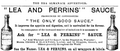 1875 ad Lea & Perrins.png 926 × 396; 126 KB
-

-
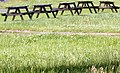 A quintet of pub benches - geograph.org.uk - 1375001.jpg 640 × 390; 272 KB
-
 A Worcestershire Nebula (15002906082).jpg 4,592 × 3,056; 3.57 MB
-

-
 Agricultural garage on the A38 - geograph.org.uk - 861289.jpg 640 × 456; 289 KB
-
 Agricultural workers' houses - geograph.org.uk - 1770204.jpg 640 × 412; 271 KB
-
 Approach to Madresfield Court - geograph.org.uk - 1765215.jpg 640 × 426; 87 KB
-
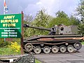 Army Surplus store at Coneybury Farm. - geograph.org.uk - 5898.jpg 640 × 480; 101 KB
-
 Astwood Bridge. - geograph.org.uk - 10688.jpg 640 × 480; 92 KB
-
 Back lane in Upper Strensham - geograph.org.uk - 1007406.jpg 640 × 480; 76 KB
-
 Bales beside the B4209 - geograph.org.uk - 1077537.jpg 640 × 426; 103 KB
-
 Below Carrington Bridge - geograph.org.uk - 1347954.jpg 640 × 455; 105 KB
-
 California Digital Library (IA biographicalillu00cham).pdf 695 × 1,162, 640 pages; 32.42 MB
-

-
 Bluebell wood in the Clent Hills.jpg 4,032 × 3,024; 8.02 MB
-

-
 Bredon tithe barn and church - geograph.org.uk - 1121652.jpg 426 × 640; 77 KB
-
 Broad Green - geograph.org.uk - 1690770.jpg 640 × 426; 99 KB
-
 Bus shelter on the Wells Road - geograph.org.uk - 1774132.jpg 640 × 427; 251 KB
-
 Caldewell Mill - geograph.org.uk - 1718901.jpg 640 × 480; 130 KB
-
 Caravan Park - geograph.org.uk - 1347962.jpg 640 × 455; 101 KB
-
 Caravan park, Clevelode - geograph.org.uk - 1346730.jpg 640 × 455; 90 KB
-
 Carboot9.jpg 1,152 × 864; 222 KB
-
 Carols on the Village Green, Hallow, Worcestershire (50683772866).jpg 3,300 × 2,203; 2.8 MB
-
 Chalets at Oakmere - geograph.org.uk - 1163374.jpg 640 × 456; 249 KB
-
 Charlton turn off the B4084 - geograph.org.uk - 852900.jpg 480 × 640; 90 KB
-

-
 Civic Centre (detail) - geograph.org.uk - 1107460.jpg 640 × 480; 129 KB
-
 Civic Centre (rear elevation) - geograph.org.uk - 1107479.jpg 640 × 367; 79 KB
-
 Civic Centre council chamber (exterior) - geograph.org.uk - 1107442.jpg 640 × 479; 115 KB
-

-
 Civic Centre, New Street - geograph.org.uk - 1107421.jpg 640 × 381; 70 KB
-
 Clinging on to life (29057927657).jpg 4,298 × 2,946; 3.66 MB
-
 Clouds in a Blue Sky. (25941365898).jpg 4,608 × 3,072; 2.84 MB
-
 Clouds in a Blue Sky. (25941379768).jpg 3,072 × 4,608; 1.84 MB
-
 Clouds in a Blue Sky. (39814007011).jpg 4,608 × 3,072; 5.02 MB
-
Cockchafer - Garden Safari May 2016.webm 1 min 38 s, 1,280 × 720; 24.34 MB
-
 Comings and goings - geograph.org.uk - 1294134.jpg 640 × 480; 84 KB
-
 Completed lych gate, Welland - geograph.org.uk - 1606066.jpg 640 × 427; 277 KB
-
 Contrast - geograph.org.uk - 1321546.jpg 640 × 428; 64 KB
-
 Cookley Tunnel - geograph.org.uk - 1252427.jpg 600 × 450; 358 KB
-
 Cookley Tunnel - geograph.org.uk - 906352.jpg 640 × 436; 110 KB
-
 Cookley Tunnel - geograph.org.uk - 906694.jpg 640 × 428; 125 KB
-

-
 Cotswold stone detail - geograph.org.uk - 1714196.jpg 640 × 483; 378 KB
-
 Country road past Heriot's Farm - geograph.org.uk - 1079025.jpg 640 × 426; 75 KB
-
 Countryside near Hurcott Wood - geograph.org.uk - 846205.jpg 640 × 414; 68 KB
-
 Countryside near Kidderminster - geograph.org.uk - 848923.jpg 640 × 452; 79 KB
-
 Countrywide Headquarters, Defford - geograph.org.uk - 515132.jpg 640 × 427; 234 KB
-
 Court Farm Lane - geograph.org.uk - 1712824.jpg 640 × 427; 258 KB
-
 Cows in the evening sunshine - geograph.org.uk - 846461.jpg 640 × 520; 100 KB
-
 Crews Hill - Worcestershire Way encounter - geograph.org.uk - 840291.jpg 640 × 480; 115 KB
-
 Croome Landscape Park - geograph.org.uk - 798140.jpg 640 × 426; 92 KB
-
 Croome Landscape Park - geograph.org.uk - 798145.jpg 640 × 426; 86 KB
-
 Worcestershire place names; (IA cu31924028041543).pdf 681 × 1,093, 208 pages; 4.04 MB
-
 Cudleigh Court Farm - geograph.org.uk - 1082322.jpg 640 × 426; 72 KB
-
 Cutting through Hagley Wood - geograph.org.uk - 1059966.jpg 640 × 480; 297 KB
-
 Daffodils and the Blue Bell - geograph.org.uk - 1776203.jpg 640 × 426; 74 KB
-
 Dandelion head, Earl's Croome - geograph.org.uk - 800325.jpg 426 × 640; 47 KB
-
 Dandelion meadow. - geograph.org.uk - 809644.jpg 640 × 427; 277 KB
-
 Dandelions in a field at Upton Snodsbury - geograph.org.uk - 809681.jpg 640 × 426; 137 KB
-
 Danters Riverside Amusements - geograph.org.uk - 1214678.jpg 640 × 480; 68 KB
-
 Dead footpath sign - geograph.org.uk - 903242.jpg 480 × 640; 102 KB
-
 Defford Bridge, Worcestershire - geograph.org.uk - 1000557.jpg 640 × 426; 67 KB
-

-
 Detail of Benchmark - geograph.org.uk - 1773783.jpg 640 × 427; 258 KB
-
 Detail, Mediaeval Barn, Bredon - geograph.org.uk - 1733769.jpg 3,072 × 2,304; 714 KB
-
 Diamond Buses ADL Pointer 2 21021 on 9C.jpg 5,184 × 3,456; 5.99 MB
-
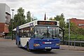
 Diamond Buses Wright Streetlite DF 20178 on 2.jpg 5,184 × 3,456; 5.28 MB
-
 Does what it says on the tin. - geograph.org.uk - 1154497.jpg 640 × 480; 71 KB
-
 Dog Lane - geograph.org.uk - 870556.jpg 640 × 338; 98 KB
-

-
 Dog waste bin, Manor Road - geograph.org.uk - 1633202.jpg 511 × 640; 160 KB
-
 Dog-leg on bridleway - geograph.org.uk - 852933.jpg 640 × 427; 307 KB
-
 Domesday Book Worcestershire.djvu 3,328 × 4,491, 13 pages; 1.71 MB
-

-
 Dripshill Wood viewed from the north - geograph.org.uk - 997559.jpg 640 × 426; 129 KB
-
 Driveway to Maisey Cottage - geograph.org.uk - 809662.jpg 640 × 427; 262 KB
-
 Driveway to Merebrook Farm - geograph.org.uk - 1163434.jpg 640 × 427; 301 KB
-
 Eckington Bridge from the air - geograph.org.uk - 793601.jpg 426 × 640; 72 KB
-
 Eckington Wharf picnic site - 1 - geograph.org.uk - 1162941.jpg 640 × 458; 90 KB
-
 Eckington Wharf picnic site - 2 - geograph.org.uk - 1162953.jpg 640 × 480; 94 KB
-
 Eight bar gate, Guarlford - geograph.org.uk - 892761.jpg 640 × 427; 299 KB
-
 Elan pipeline - Hayley Green supply tap - geograph.org.uk - 1059916.jpg 640 × 480; 280 KB
-
 Emerging from under the A449 - geograph.org.uk - 1519426.jpg 640 × 480; 90 KB
-
En-us-Worcestershire.oga 1.0 s; 14 KB
-
En-worcestershire.ogg 2.2 s; 24 KB
-
 Entering Church Lench - geograph.org.uk - 921899.jpg 640 × 480; 116 KB
-
 Entering Rous Lench - geograph.org.uk - 922633.jpg 640 × 480; 132 KB
-
 Entrance to rape field - geograph.org.uk - 809428.jpg 640 × 427; 283 KB
-

-
 Entrance to Three Counties Park - geograph.org.uk - 849149.jpg 640 × 480; 206 KB
-
 Entrance to Uffmoor Wood - geograph.org.uk - 1543827.jpg 640 × 473; 116 KB
-
 Entrance to Whiteacres - geograph.org.uk - 898332.jpg 640 × 427; 294 KB
-
 Ernest Pritchard's seat - geograph.org.uk - 818896.jpg 640 × 427; 314 KB
-
 Falconers Farm - geograph.org.uk - 1076569.jpg 640 × 426; 91 KB
-
 Farm buildings at Pye Corner - geograph.org.uk - 1543902.jpg 640 × 480; 233 KB
-
 Farmland near Collett's Green - geograph.org.uk - 1607188.jpg 640 × 426; 94 KB
-
 Farmland near Defford - geograph.org.uk - 792599.jpg 640 × 426; 101 KB
-
 Farmland north of Church Lench - geograph.org.uk - 922536.jpg 640 × 480; 101 KB
-
 Farmland to the west of Defford - geograph.org.uk - 792606.jpg 640 × 426; 99 KB
-
 Fetterlocks Cottage - geograph.org.uk - 959189.jpg 640 × 480; 91 KB
-

-
 Fine farmhouse Worcestershire (50946733328).jpg 4,896 × 3,264; 13.67 MB
-

-
 Fishing HQ - geograph.org.uk - 922194.jpg 640 × 480; 127 KB
-
 Fishing platform - geograph.org.uk - 1346912.jpg 640 × 455; 126 KB
-
 Fishing Platform, Meadowlands - geograph.org.uk - 1347746.jpg 640 × 455; 132 KB
-
 Fladbury lock - 2 - geograph.org.uk - 1105310.jpg 411 × 640; 100 KB
-
 Flats old and new - geograph.org.uk - 1057064.jpg 640 × 372; 69 KB
-
 Flood depth indicators, Fleet Lane - geograph.org.uk - 1121690.jpg 640 × 426; 93 KB
-
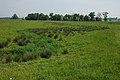
 Flood plain of the Mill Brook - geograph.org.uk - 848477.jpg 640 × 445; 270 KB
-

-
 Floral Archaeology - geograph.org.uk - 809279.jpg 640 × 427; 279 KB
-
 Football pitches - geograph.org.uk - 838865.jpg 640 × 480; 62 KB
-
 Forge being redeveloped - geograph.org.uk - 1710846.jpg 640 × 480; 80 KB
-
 Former A road at Stoulton - geograph.org.uk - 1621586.jpg 640 × 426; 84 KB
-
 Former approach to Croome Court - geograph.org.uk - 797733.jpg 640 × 426; 94 KB
-
 Former Garage, Flyford Flavell - geograph.org.uk - 846721.jpg 640 × 480; 75 KB
-
 Fortified observatory, Wast Hills - geograph.org.uk - 151866.jpg 640 × 480; 256 KB
-
 Frosty morning, Portock's End - geograph.org.uk - 1076570.jpg 640 × 426; 84 KB
-
 Frosty tree at Madresfield - geograph.org.uk - 1076575.jpg 640 × 426; 81 KB
-
 Froxmere Court and Bow Wood - geograph.org.uk - 80508.jpg 640 × 479; 102 KB
-
 Frozen field - geograph.org.uk - 1076568.jpg 640 × 426; 117 KB
-
 Frozen land, near Clevelode - geograph.org.uk - 1079021.jpg 640 × 426; 87 KB
-

-
 Funfair, Stourport-on-Severn - geograph.org.uk - 1651708.jpg 2,848 × 2,136; 4.06 MB
-
 Gardeners' World stand - geograph.org.uk - 1294116.jpg 640 × 480; 158 KB
-

-
 Gateway Park - geograph.org.uk - 1453749.jpg 640 × 480; 90 KB
-
 Gathering the sheep, Longdon Marsh - geograph.org.uk - 851088.jpg 640 × 428; 291 KB
-
 George Judge's boat yard, Hawford. - geograph.org.uk - 1216713.jpg 640 × 480; 95 KB
-
 Giant Hogweed rising - geograph.org.uk - 795174.jpg 640 × 427; 345 KB
-
 Glebe House, near Longdon Heath - geograph.org.uk - 839089.jpg 640 × 480; 104 KB
-
 Going uphill - geograph.org.uk - 833417.jpg 640 × 480; 95 KB
-
 Gold medal cacti - geograph.org.uk - 1293774.jpg 480 × 640; 250 KB
-
 Golden Milk (18186245463).jpg 5,456 × 3,529; 10.7 MB
-
 Grass field on edge of Springfield Park - geograph.org.uk - 796777.jpg 640 × 480; 105 KB
-
 Grass field on edge of Springfield Park - geograph.org.uk - 798511.jpg 640 × 480; 128 KB
-
 Grassland at Holly Green - geograph.org.uk - 836262.jpg 640 × 480; 95 KB
-
 Grazing land at Sedgeberrow - geograph.org.uk - 1777906.jpg 640 × 426; 71 KB
-
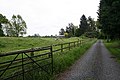
 Green Lane - geograph.org.uk - 1770108.jpg 640 × 427; 256 KB
-
 Green lane to Lower Arles Wood - geograph.org.uk - 1077090.jpg 426 × 640; 128 KB
-
 Hanley Road junction - geograph.org.uk - 1773810.jpg 640 × 407; 216 KB
-
 Hanley Workshops - geograph.org.uk - 1163511.jpg 640 × 392; 240 KB
-
 Harpley Road bridge at Defford - geograph.org.uk - 1748753.jpg 1,500 × 958; 282 KB
-
 Hawthorn tree, Kemerton Hillfort - geograph.org.uk - 1158890.jpg 426 × 640; 71 KB
-

-
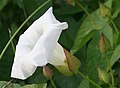 Hedge Bindweed - geograph.org.uk - 868206.jpg 640 × 471; 258 KB
-
 Hedgehogs in Nunnery Wood - geograph.org.uk - 839542.jpg 640 × 480; 129 KB
-
 Hen houses near Lower Arles Wood - geograph.org.uk - 1166995.jpg 640 × 427; 355 KB
-
 Herriots Farm, Guarlford - geograph.org.uk - 892747.jpg 640 × 427; 267 KB
-
 High In Abberley - geograph.org.uk - 1174392.jpg 640 × 428; 83 KB
-
 Hilltop windmill site^ - geograph.org.uk - 898705.jpg 640 × 427; 258 KB
-
 Himalayan Birch (1361963675).jpg 1,880 × 3,404; 5.35 MB
-
 Hollies Farm and cattle - geograph.org.uk - 898826.jpg 640 × 469; 82 KB
-
 Home Farm, Madresfield - geograph.org.uk - 1076442.jpg 640 × 426; 105 KB
-

-
 Hornyold Apartments - geograph.org.uk - 1773807.jpg 640 × 427; 226 KB
-
 Hospital boiler house - geograph.org.uk - 1107076.jpg 480 × 640; 38 KB
-
 House beside Severn near Arley - geograph.org.uk - 1255776.jpg 484 × 640; 155 KB
-
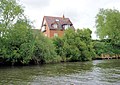 House by the Severn - geograph.org.uk - 1349339.jpg 640 × 455; 99 KB
-
 House by the Severn, Uckinghall - geograph.org.uk - 1349342.jpg 640 × 455; 109 KB
-
 House Martin, Delichon urbicum...mud collecting - Flickr - gailhampshire.jpg 2,392 × 1,944; 792 KB
-
 House, Church End - geograph.org.uk - 1346850.jpg 640 × 455; 136 KB
-
 House, Clevelode - geograph.org.uk - 1346738.jpg 640 × 455; 117 KB
-
 Houses at Broad Green - geograph.org.uk - 1690772.jpg 640 × 426; 104 KB
-
 Houses in Sedgeberrow - geograph.org.uk - 1777917.jpg 640 × 426; 74 KB
-
 Houses on the road to Naunton - geograph.org.uk - 1755647.jpg 640 × 427; 262 KB
-
 Huddington Farm, Huddington - geograph.org.uk - 809593.jpg 640 × 426; 83 KB
-
 Huge ploughed field - geograph.org.uk - 841923.jpg 640 × 480; 64 KB
-
 Hurcott Lane Bridge - geograph.org.uk - 800983.jpg 536 × 640; 137 KB
-
 Ice on white car (32284788740).jpg 3,690 × 2,197; 1.75 MB
-

-
 Inside a small sandstone cave - geograph.org.uk - 898960.jpg 640 × 497; 137 KB
-
 Inside a small sandstone cave - geograph.org.uk - 898968.jpg 480 × 640; 125 KB
-
 John Wheeley Lea.jpg 533 × 685; 49 KB
-
 King George's Field, Pershore - geograph.org.uk - 1058772.jpg 426 × 640; 128 KB
-
 Kissing gate into dandelion meadow - geograph.org.uk - 809652.jpg 640 × 427; 264 KB
-
 Lane Junction Near Spring Ridge - geograph.org.uk - 1767929.jpg 640 × 480; 137 KB
-
 Lane junction on Castlemorton Common - geograph.org.uk - 1134214.jpg 640 × 480; 90 KB
-
 Lane off Wilden Lane - geograph.org.uk - 1638794.jpg 640 × 480; 88 KB
-
 Lane to Wilden - geograph.org.uk - 1637943.jpg 640 × 472; 87 KB
-
 Larford Farm - Holiday Park and Chalets - geograph.org.uk - 1400560.jpg 640 × 480; 180 KB
-
 Large Skipper. u-s - Flickr - gailhampshire.jpg 2,608 × 2,328; 492 KB
-
 Large Skipper...sunbathing. - Flickr - gailhampshire.jpg 2,080 × 1,768; 273 KB
-
 Lasioglossum species female - Flickr - gailhampshire.jpg 2,368 × 1,960; 483 KB
-

-
-
 Left Overs From The Rally - geograph.org.uk - 1400764.jpg 640 × 480; 170 KB
-
 Lesser Celandine - Flickr - gailhampshire.jpg 1,518 × 1,368; 400 KB
-
 Lichen crust - geograph.org.uk - 825468.jpg 640 × 473; 317 KB
-
 Lidl supermarket - geograph.org.uk - 779353.jpg 640 × 480; 51 KB
-
 Light at the end of the tunnel - - geograph.org.uk - 1453742.jpg 640 × 480; 60 KB
-
 Limenitis camilla. White Admiral - Flickr - gailhampshire.jpg 2,713 × 2,464; 717 KB
-
 Limenitis camilla. White Admiral underwing - Flickr - gailhampshire.jpg 3,728 × 3,392; 1.37 MB
-
 Limestone Woundwort - Flickr - gailhampshire.jpg 1,440 × 1,908; 370 KB
-
 Longdon Marsh - geograph.org.uk - 851111.jpg 640 × 427; 273 KB
-


%27_(11232570835).jpg)

.jpg)


.jpg)


_-_geograph.org.uk_-_1107460.jpg)
_-_geograph.org.uk_-_1107479.jpg)
_-_geograph.org.uk_-_1107442.jpg)


.jpg)
.jpg)
.jpg)
.jpg)


_in_Hurcott_Wood_-_geograph.org.uk_-_1347930.jpg)


.jpg)


.jpg)


.jpg)


.jpg)


