Category:Badergasse 4 (Wiesentheid)
Jump to navigation
Jump to search
This is the category of the Bavarian Baudenkmal (cultural heritage monument) with the ID D-6-75-178-2 (Wikidata)
|
| Object location | | View all coordinates using: OpenStreetMap |
|---|
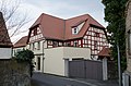
Deutsch: Wohnhaus. Halbwalmdachbau über gebrochenem Grundriss, mit geohrten Fensterrahmungen im Erdgeschoss, Fachwerkobergeschoss, 18./19. Jahrhundert. Badergasse 4, Wiesentheid, Landkreis Kitzingen, Unterfranken, Deutschland.
cultural heritage monument D-6-75-178-2 (0) in Wiesentheid, Bavaria  | |||||
| Upload media | |||||
| Instance of | |||||
|---|---|---|---|---|---|
| Location | Wiesentheid, Kitzingen, Lower Franconia, Bavaria, Germany | ||||
| Street address |
| ||||
| Heritage designation | |||||
 | |||||
Media in category "Badergasse 4 (Wiesentheid)"
The following 2 files are in this category, out of 2 total.
-
 Wiesentheid, Badergasse 4, 001.jpg 4,928 × 3,264; 9.5 MB
-
 Wiesentheid, Badergasse 4, 002.jpg 4,928 × 3,264; 8.4 MB
