Category:Bahnhof Niederselters
Jump to navigation
Jump to search
| Object location | | View all coordinates using: OpenStreetMap |
|---|
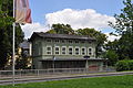
railway station in Niederselters, Germany  | |||||
| Upload media | |||||
| Instance of | |||||
|---|---|---|---|---|---|
| Location |
| ||||
| Street address |
| ||||
| Operator | |||||
| Heritage designation | |||||
| Date of official opening |
| ||||
| Elevation above sea level |
| ||||
| Connecting line | |||||
| official website | |||||
 | |||||
This is the category of the Hessian Kulturdenkmal (cultural monument) with the ID 51992 (Wikidata)
|
Media in category "Bahnhof Niederselters"
The following 2 files are in this category, out of 2 total.
-
 Niederselters, Bahnhof, Rückseite.JPG 4,288 × 2,848; 5.99 MB
-
 Niederselters, Bahnhof, Vorderseite.JPG 4,288 × 2,848; 5.04 MB
