Category:Bandiagara Escarpment
Salti al navigilo
Salti al serĉilo
|
This place is a UNESCO World Heritage Site, listed as
Cliff of Bandiagara (Land of the Dogons).
|
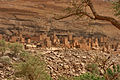
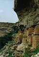
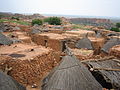
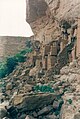
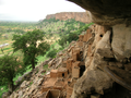
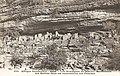
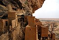
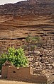
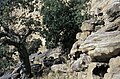
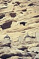
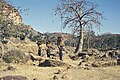
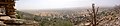
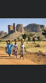
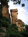
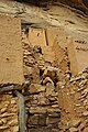
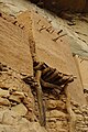
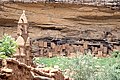
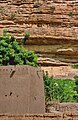
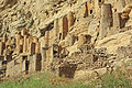
English: The Bandiagara Escarpment — located in the Sahel region of Mali.
- Inhabited by the Tellem and Toloy formerly, and the Dogon peoples presently.
- The Tellem and Dogon architecture styles of cliff dwellings and mud buildings in Mali are in this World Heritage Site.
Escarpment in Dogon country of Mali  | |||||
| Alŝuti plurmedion | |||||
| Estas | |||||
|---|---|---|---|---|---|
| Loko | Regiono Mopti, Malio | ||||
| Heredaĵa statuso |
| ||||
| IUCN protected areas category | |||||
| Areo |
| ||||
| Supermara alteco |
| ||||
| Alia ol | |||||
 | |||||
Subkategorioj
Ĉi tiu kategorio havas la 3 jenajn subkategoriojn, el 3 entute.
B
T
- Tellem dwellings (17 D)
- Toloy dwellings (3 D)
Dosieroj en kategorio “Bandiagara Escarpment”
La jenaj 61 dosieroj estas en ĉi tiu kategorio, el 61 entute.
-

-

-

-

-

-
 Bandiagara escarpment 1.jpg 2 336 × 3 504; 3,93 MB
-
 Bandiagara escarpment 2.jpg 3 504 × 2 336; 3,73 MB
-
 Bandiagara escarpment by David Sessoms 1.jpg 1 944 × 2 592; 1,18 MB
-
 Bandiagara escarpment by David Sessoms 2.jpg 1 944 × 2 592; 1,32 MB
-
 Bandiagara escarpment by David Sessoms.jpg 2 592 × 1 944; 1,25 MB
-
 Bandiagara Escarpment Mali.jpg 900 × 602; 230 KB
-
 Bandiagara falla.JPG 3 648 × 2 736; 2,11 MB
-
 Bandiagara.jpg 238 × 350; 22 KB
-
 Bandiagara.JPG 1 700 × 1 110; 913 KB
-

-

-
 Danse des habitants des cavernes-Région de Bandiagara (AOF).jpg 1 626 × 1 048; 827 KB
-
 Dogon Country banner.jpg 2 466 × 353; 264 KB
-
 Dogon country by David Sessoms 2.jpg 2 592 × 1 944; 1 MB
-
 Dogon village by David Sessoms.jpg 2 592 × 1 944; 1,54 MB
-
 Dogon village rooftops by David Sessoms.jpg 2 592 × 1 944; 1,55 MB
-
 Falaise de bandiagara (6474689).jpg 1 829 × 2 771; 4,72 MB
-
 Falaise de Bandiagara.png 566 × 377; 497 KB
-
 Falaise de bandiagara1.jpg 406 × 604; 59 KB
-
 Falaise de Bandiagara2.jpg 604 × 413; 53 KB
-
 Falaise de Bandiagara3.jpg 604 × 413; 43 KB
-
 Landscape Dogon Mali.png 1 024 × 768; 4,01 MB
-
 Les Falaises de Bandiagara.jpg 1 600 × 1 200; 759 KB
-
 Les montagnes du Macina-Habitations des Habbès (AOF).jpg 1 618 × 1 031; 1,08 MB
-
 Mali - Pays Dogon (falaise de Biandagara) (13667559705).jpg 2 896 × 1 944; 1,38 MB
-
 Mali Dogon 02.jpg 509 × 800; 98 KB
-
 Mali Dogon 03.jpg 800 × 508; 123 KB
-
 Mali1974-046 hg.jpg 2 625 × 4 008; 1,81 MB
-
 Mali1974-048 hg.jpg 4 041 × 2 672; 1,84 MB
-
 Mali1974-051 hg.jpg 4 037 × 2 668; 2,52 MB
-
 Mali1974-052 hg.jpg 4 010 × 2 652; 1,98 MB
-
 Mali1974-053 hg.jpg 2 678 × 4 043; 1,79 MB
-
 Mali1974-056 hg.jpg 4 033 × 2 381; 1,91 MB
-
 Mali1974-058 hg.jpg 4 029 × 2 146; 1,33 MB
-
 Mali1974-059 hg.jpg 2 649 × 4 009; 1,98 MB
-
 Mali1974-062 hg.jpg 3 974 × 2 656; 2,12 MB
-
 Mali1974-064 hg.jpg 4 022 × 2 652; 1,81 MB
-
 Mali1974-067 hg.jpg 3 986 × 2 511; 1,51 MB
-
 Mali1974-070 hg.jpg 2 638 × 3 946; 1,66 MB
-
 Matériel funéraire Dogon, falaise de Bandiagara P1070799.jpg 1 809 × 1 914; 1,5 MB
-
 OSM Sangha (Mali).jpg 1 266 × 675; 97 KB
-
 Panorama Dogon.jpg 8 995 × 1 986; 2,38 MB
-
 Plaine de bandiagara.png 750 × 1 334; 2,67 MB
-
 Rock formation in Dogon country.jpg 1 944 × 2 592; 1,22 MB
-
 Tam-tam de Habbès-Région de Bandiagara (AOF).jpg 1 617 × 1 039; 556 KB
-
 TeliVillage.JPG 2 592 × 3 872; 1,9 MB
-
 TeliVillage2.JPG 2 592 × 3 872; 3,51 MB
-
 TeliVillage4.JPG 3 872 × 2 592; 4,03 MB
-
 Tellem Dwelling Bandiagara Escarpment Mali.jpg 900 × 600; 185 KB
-
 Tellem Dwellings above Dogon hut.jpg 1 770 × 2 718; 2,42 MB
-
 Tellem Dwellings above Dogon huts.jpg 2 714 × 1 768; 2,84 MB
-
 Telli bandiagara.jpg 2 592 × 3 872; 1,44 MB
-
 TelliVillage.JPG 3 872 × 2 592; 2,06 MB
-
 Village Dogon1.jpg 604 × 416; 55 KB
-
 Village Telly in Mali.jpg 3 504 × 2 336; 4,58 MB
-
 Villagedogon.jpg 3 872 × 2 592; 2,77 MB


.jpg)


.jpg)


.jpg)
_(13667559705).jpg)


.jpg)


.jpg)


